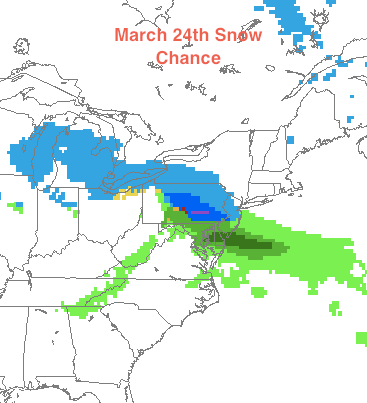
Oh boy, snow. Just when people think it’s over, more of the white stuff could be on the way. This is something I’ve been watching for the past few days now, but recently there has been some model guidance that shows a decent snowfall Wednesday into Thursday. I am going to stay very cautious with this snowstorm as it is extremely rare we see any snow in late March.
The most likely scenario is some mix of rain and snow at night on Wednesday changing to rain by Thursday. But there is a slim chance that enough cold air is brought in to change the mix to snow at Wednesday night and delay the transition to rain on Thursday. Any snow that falls Wednesday night will be heavy and wet (good for snowballs). I will continue to track this storm as it gets closer and will continue to update on its status.
Anyway, here is the snow situation I’m looking at right now from the NAM model (2AM Thursday):

And finally, here is the forecast:
Monday: Rain in the morning, clearing out by evening Hi: 58 Low: 43
Tuesday: Sunny Hi: 51 Low: 33
Wednesday: Becoming cloudy with some mix (snow?) at night Hi: 44 Low: 32
Thursday: Snow or rain Hi: 40 Low: 32
