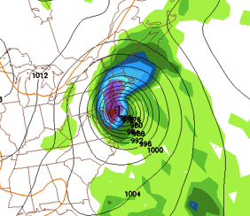
Update 12:05 AM: GFS forecast model has just switched to scenario 1. Cat 1 winds into Philadelphia…
Much has happened with Irene since my last update. She has turned into a category 3 hurricane and is eying the Eastern seaboard. Still, the forecast models have not been in complete consensus for this storm. What is known is that Irene will be a category 2 Hurricane coming up the coast. She has avoided going over any land, and will continue to until she clips Cape Hatteras. This means trouble for the big cities in the Northeast. Our environment and infrastructure are not prepared for any storm of this magnitude. This is why I am asking everyone to start to make preparations now for Irene.
Right now there are two possible scenarios
1. Here is an image from the most trustworthy forecast model, the european, for Sunday afternoon. It is showing a strong cat 1 or cat 2 storm heading up NJ. This is right now the worst case scenario for our area. Hurricane force winds along with around 7-8 inches of rain would be expected from this scenario. :

2. The other scenario comes from the GFS (another trustworthy forecast model). It brings the storm a little further east, leaving us out of the hurricane force winds. We would still receive 6 inches of rain, however.:

Both of these scenarios are possible and I am not leaning toward one over the other. By Friday, I expect Irene’s track to be ironed out and any vague details cleared up.
Finally, for anyone not aware with the Saffir-Simpson hurricane wind scale, I have provided a table below that talks about it. As you can see, even category 1 winds are extremely damaging. This is why I recommend starting to prepare now for Irene. :

I will continue to update Irene’s status as the week progresses.
Go to this webpage for more on Hurricane Preparedness: http://www.nhc.noaa.gov/outreach/prepare.shtml
