Sorry for the lack of posts everyone, as I have been sick with a cold/sinus infection. The past week has been very tough for any snow lover. Temperatures reached into the 50s and even 60 last week, with rain and clouds dominating the landscape. Our pattern has become fairly active, and we will continue to see small systems move through this week. Temperatures should start out mild this week, with some uncertainty heading into Friday. Thursday night into Friday morning, a possible storm could affect the region with some rain or snow. Stay tuned.
Teleconnection Update:
As I have explained in previous posts, the teleconnections are key to see if a cold and snowy pattern will return by the end of winter. The NAO, AO, PNA, and MJO are just a few of the important teleconnections used by many meteorologists to determine future trends.
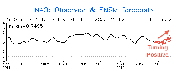
The NAO has been positive all winter. This teleconnection has been a reason why we have not seen many strong coastal storms and colder weather this winter. At this point, it looks like the NAO becomes negative for 2-4 days (February 4-8th)before turning positive again. This should mean we will see more of the same in terms of storm track through mid February. But there are other factors… (see next paragraph)

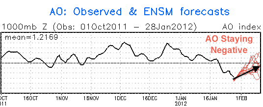
The AO (Arctic Oscillation) is a teleconnection used by any credible forecaster to determine whether the upcoming pattern will be a snowy one or not. The NAO and the AO are very similar teleconnections and are known to affect each others indexes. The AO measures the temperature anomalies of the waters in the arctic circle. When the AO is negative, expect snowy conditions with some brutal cold air. Our snow outbreak of 2010 involved a record negative AO. 9 out of 10 coldest Januarys in NYC have been correlated with an extremely negative AO. This winter, the AO has been extremely positive, explaining the above average warmth we have had so far. But recently, the AO have been substantially negative and will continue to over the next two weeks. This is where a conflict comes in. The NAO is expected to move positive, but the AO will be negative. What will happen? I look toward the PNA and MJO, the two other important teleconnections, for more answers.

The last teleconnection I will overview is the PNA. The PNA (Pacific North American teleconnection pattern) measures the relation between the atmospheric circulation between the North Pacific and North America. A positive PNA usually means below average temperatures for the east coast, while negative values means above average temperatures for the east coast. This winter, the PNA has been neutral and has not been much of a factor. The PNA is expected to go slightly positive over the next two weeks.
All three of these teleconnections need to be favorable (negative NAO, negative AO, positive PNA) for the eastern seaboard to receive a major snowstorm. The last two winters the teleconnections were perfect for snowstorms. The NAO and AO were safely negative, while the PNA stayed positive. Right now, the NAO is the only teleconnection that is not in a favorable position. It is expected to go slightly negative around the 4th-8th. This time period is when I am expecting a possible snowstorm to affect the region. This winter has been frustrating. Even though our weather has been rainy and warm with some spurts of cold weather, I expect one major storm to affect the region by the end of February. Most of the stones are in place, and it is only a matter of time until the keystone fits.
-Jason
