Warmer temperatures will dominate the rest of the week as a high pressure system will setup just to our southeast. Temperatures will reach the high 40s tomorrow and into the 50s on Friday. A weak cold front will pass on Friday as well, giving us a soggy and dreary end of the week. However, all of my attention right now is focused on the possible big storm on Sunday.
After the cold front pulls through, moisture part of the southern jet will start to organize in the Gulf of Mexico. Another weaker low will form in the midwest, part of the northern jet. These two disturbances have a potential to phase and undergo cyclogenesis, intensifying rapidly. There is no doubt that a strong storm is coming. There is doubt about where the phasing will occur and when the storm will intensify. Many models are showing different solutions right now and every run varies. As a result, I will introduce two scenarios:
Scenario 1: Out to sea. Ah, our friendly “out to sea” solution. I have to say, I am leaning toward this solution. The teleconnections are fairly unfavorable for any quick phasing and blocking, and there just does not seem neutral/negative tilt to the trough. In this scenario, the storm will suppress to the south and not even phase with the northern jet. No precipitation would be expected and temperatures would be seasonable for this time of year. Right now, the European model is showing this solution. Here is the European at 114 hours out (1 AM Monday):

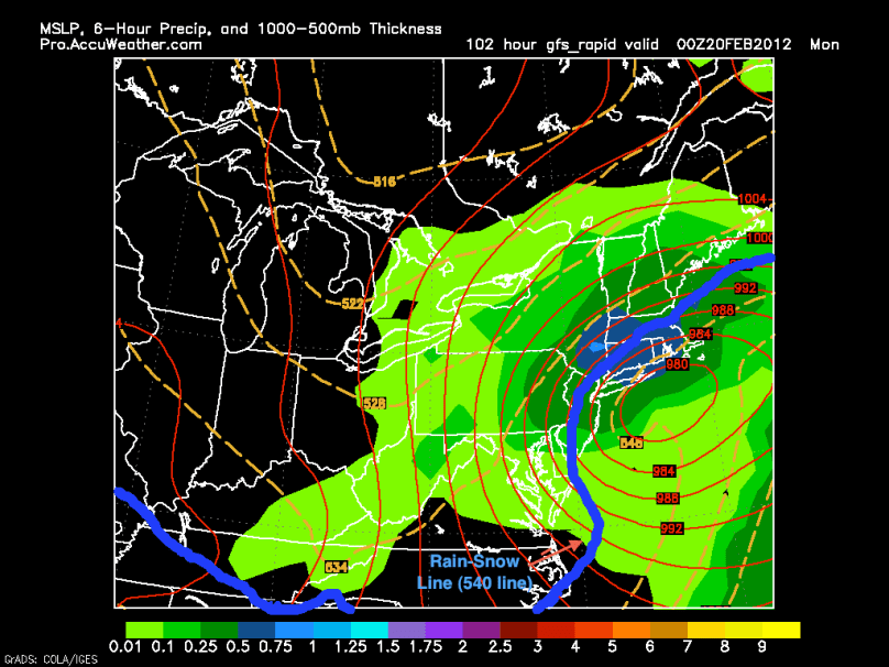
Scenario 2: Storm along the coast. This scenario represents the classic nor’easter. The jets will phase and the storm will rapidly strengthen, bring in its own cold air, and ride the coast. Right now, this scenario has one inherited problem: there just is not enough cold air initially to bring us a 100% snowstorm. Because it seems like the jet will be flat and our temperatures will be in the 40s, it will be tough for our area to receive all snow from this scenario. However, I do like the setup of the storm and if it can wrap around enough cold air…look out snowlovers! The GFS model currently is showing this scenario:

Over the next few days, the forecast models should reach a more promising consensus. I will continue to post any updates about this storm.
-Jason
