Yes! Philaburbia is back. Winter, snow, ice, and sleet are coming. It should be a wild and entertaining ride.
First on our agenda today are some stats from this summer. It was the 3rd warmest summer on record in the contiguous United States with an average temperature of 74.4 degrees. In the northeast, we had the 10th warmest June-August on record. Considering September was fairly average, I do not expect this rank to change significantly. Precipitation-wise from June-August the northeast received close to the average amount of rain expected. It was the 18 driest June-August overall in the country.
All this data can be found here… take a look, there are some very cool maps: http://www.ncdc.noaa.gov/sotc/national/2012/8
Tropics! In May, I predicted 10 named storms this year with 2 landfalls. In actuality, there were 14 named storms, 8 hurricanes, 1 major hurricane, and 3 US landfalls (Beryl, Debbie, and Isaac). My forecast was based on the weak el Niño forming from a fairly weak La Niña in the winter. Since there were only 7-8 years of this pattern in record, I did not have much data to work with. Even though Isaac created massive amounts of damage in the South, no major hurricane hit the Gulf or East coast this year. Hopefully this pattern will continue for as long as possible.
Here is the El Niño/La Niña map. Just as a refresher, positive anomalies mean El Niño; negative La Niña:

Now for some current weather:
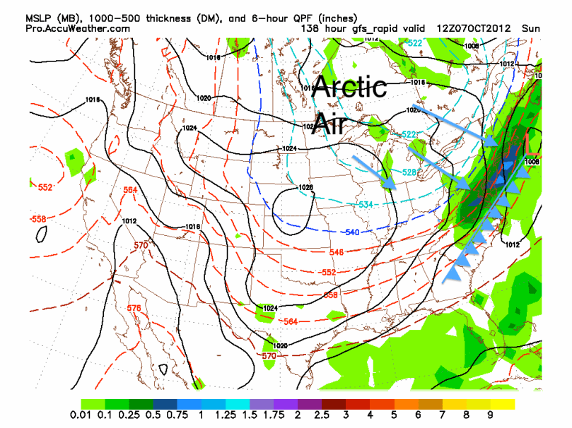
A weak low pressure will pass to our south and head out to sea. Some of this moisture from this front will reach our area tomorrow and Wednesday before high pressure sets up in the Southeast. Temperatures should increase by the end of the week (maybe some 80s), before a strong cold front crosses this Saturday Night/Sunday. After the front crosses, expect temperatures to tumble. It will likely be in the 60s next week and could drop into the 50s for highs the week after. It does not look like summer is returning for quite a while.
Here is the GFS model at 8 AM Sunday showing the cold front crossing the region. I made some cheap graphics to help people visualize (the dark blue line means the upper atmosphere is just below freezing (supports snow), but does not, however, necessarily mean surface temperatures are below freezing):

As Joe Bastardi says: “Enjoy the weather, cause it’s the only weather you got!”

Thanks for the weather update, Jason
When do you think we will get the 1st frost?
Hope school’s going well at Haverford.
Clifford
Temperatures will go down into the upper 30s this Sunday night. After that though, it doesn’t look we will get below freezing until at least mid October. Don’t worry, I will definitely let you know when 1st frost looks imminent.