
Prologue:
After a looooong hibernation/break/vacation/furlough, Philaburbia Weather Blog is back! It has been over 8 months since my last post, and frankly, I am excited to be back in the blog seat. Since my last post, there have been tragedies (RIP Tim Samaras), severe weather, wildfires, floods, and a government shutdown (which has limited my resources immensely for this blog…sad face):
With that said, Philaburbia Weather is back! To all my readers, I will continue to produce the most accurate forecasts in the Delaware Valley. I will not let you down. Promise.
Now, let’s get to the weather!!
Chapter 1: Hurricane Discussion
The 2013 hurricane season has been a quiet one. We have had eleven named storms (which is normal), two hurricanes, and no major hurricanes. We have seen in recent years how difficult it is to predict hurricane activity each year. Most sources were calling for 8-9 hurricanes with 3-5 major hurricanes and a heightened risk of a US impact. So far, none of these predictions have proved accurate and it does not look like a tropical system will be affecting us in the near future.
Chapter 2: Short Range Discussion
Volatile temperature changes are the big story for the upcoming week. While not unusual for this time of year, we are expecting a 20 degree drop in temperature between today and next Thursday! Before this temperature change, however, some weak disturbances will be pulling through the area Thursday night and Saturday night.
By next Tuesday, a low pressure will form over the great lakes and start to move east. Behind the front associated with the low, unseasonably cold air will follow. The european forecast model depicts this scenario:

After this front pulls through with minimal precipitation, high temperatures will drop into the low 50s in the day and around freezing at night. This means the northern and western suburbs could receive their first frosts by next weekend. Enjoy the fairly warm for the rest of this week and weekend because….. winter is coming (cue Game of Thrones music)!
Chapter 3: Long Range Discussion
The essential question brought up each fall vexes me every year: How much snow are we getting this winter? Well, it is extremely hard to pin-point exact totals for any location. It is also extremely difficult to predict temperature and precipitation patterns for the upcoming winter. My theory for this failure in forecasting is lack of recorded data. We just do not have enough precedents to be able to successfully predict what will happen each winter.
But,
I will attempt to relate past winters in terms of the upcoming weak El Niño period this year. Technically called analog winters, these past seasons have had a similar El Niño as we will have for winter 2013-2014. Using some data from the Climate Prediction Center, I have concluded that a handful of analog winters could be considered: 1968-1969, 1976-1977, 1977-1978, 2002-2003, 2004-2005. Coincidentally, every single one of these analog seasons have been above normal and have had a major snowstorm affect the Northeastern US. What does this mean for this winter? My call for the winter of 2013-2014 is a warmer than average winter with one large snowstorm for the northeast. Put it down in the books.
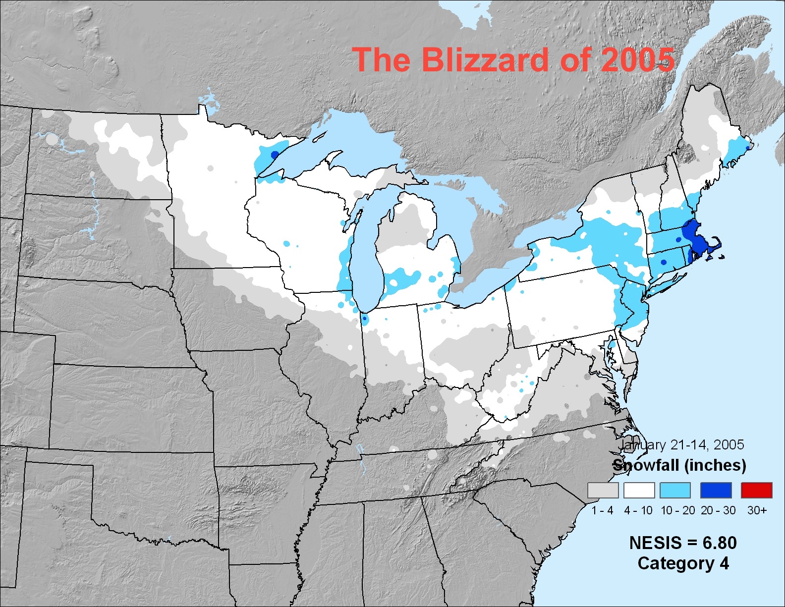
By the way, here’s a snowfall total map for the blizzard of 2005, which dropped over a foot of snow in the Philadelphia region:
Epilogue:
Next post will deal with more discussion of the analog winters as well as the possibility for the first flurry (oh boy oh boy) in early November. If you have any feedback, comment. Like my Facebook page: https://www.facebook.com/pages/Philaburbia-Weather/125766690824958. Also tell your friends that the blog is back… spread the word.
Till next time,
JHirsch

Welcome back, Jason
Thanks for the winter prediction and will look forward to your future posts.
Clifford