
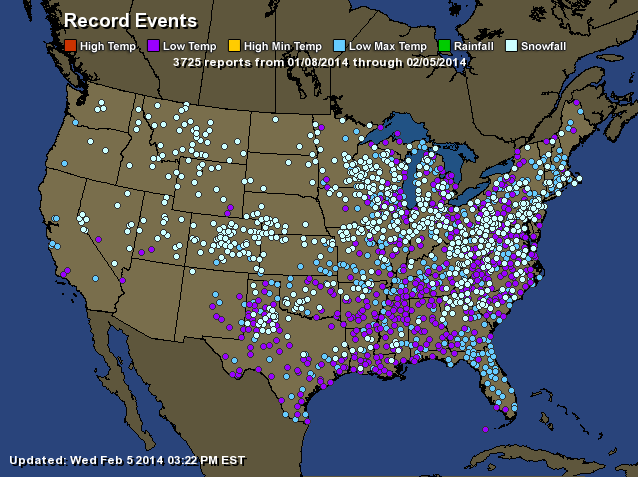
As I alluded to a couple posts ago, this February would be much stormier than previous months. Our pattern has continued to be cold however, and it does not look like any relief is in sight until at least late-February. It has been quite the last 6 weeks since the “Polar Vortex” took control over Canada post-New Years! The map below shows the astonishing number of minimum-maximum temperatures as well as record low temperatures over the Eastern part of the country (3725 reports):
The stormy pattern is actually good for breaking the brutal cold. We are starting to finally transition to a spring pattern, as the jet stream is becoming more active compared to earlier this winter.
Short Term: Nuisance Clipper Tomorrow:
The “bigger, badder” storm that I was talking about earlier this week will be a nuisance clipper system that will move through the region tomorrow. What prevented this storm from taking shape? The southern and northern jets did not phase, which would have created a very large nor’easter. Instead we have a small system that will drop 2-3 inches of snow around the region tomorrow.

Long Range Forecast: Valentine’s Day Storm
I have been tracking this storm for the past week or so. It does look like something will materialize from this threat, but its effects on the region are still up in the air. Where the models are differing the timing of the phase between the secondary and primary low pressures. The two maps below are from the GFS (bottom image) and European (top image) models . The GFS shows a phase, but takes out all cold air aloft and at the surface to give our area mostly rain. The European doesn’t phase the two systems at all, and is a much weaker solution. It does bring in cold air, which means that the precipitation would be snow.
These differences make forecasting events like this very difficult. The Teleconnections (NAO, PNA, AO) have not been significant whatsoever (mostly neutral or around neutral), and we are in a neutral ENSO (El Nino, La Nina) phase right now. These factors make forecasting snowstorms even more onerous. Hopefully, my confidence levels will rise into the beginning of the work week, when we can actually observe the locations of the two low pressures.


The timing of this storm looks to be either on Thursday or Friday, depending on the timing of the phase. I will post an update later next week with more details and whether another snowstorm is on its way.
