
Hey everyone. After a spring/summer hiatus, Philaburbia Weather is back for the 2014-2015 winter season!
I want to start this post off by thanking everyone for staying with Philaburbia through the years. We are heading into our 5th winter and I hope you are as excited as I am for the coming months ahead!
First on the agenda is the tropical outlook. The 2014 hurricane season in the Atlantic is about to officially end. With only 9 named storms, it has been a fairly unremarkable season in the tropics. A couple factors including cooler than normal ocean temperatures and a weak El Niño contributed to the lessened activity in the Atlantic.

My mention of the El Niño leads us into the next topic: What’s in store for the 2014-2015 winter season?
A couple of major factors will determine how cold and snowy our winter will be:
1. Strength of the El Niño: This parameter has been known to heavily influence our winters year in and year out. In a nutshell, an El Niño means that water temperatures off the coast of Peru are above normal. No one knows the exact reasons for El Niño’s effects on our winter weather, but research has been done to prove correlations between strength of the El Niño and meteorological averages in the continental United States.

We are currently headed into a weak El Niño from a weak La Niña last winter (see chart above). With El Niño winters, temperatures tend to be warmer than average in the Northeastern United States. Unfortunately, the magnitude of the El Niño this winter will be marginal at best, which makes it difficult to predict how warm this winter will be. I did, however, find a couple of analog winters. These could support a general trend for this winter.
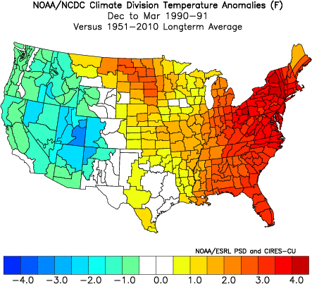
Analog winter: 1990-1991. The first winter I chose to analyze was the winter of 1990-1991. This winter was one of the warmest on record for the Eastern United States. The El Niño recorded during this period was weak (see http://ggweather.com/enso/oni.htm for more), but was likely largely influential on the unusual warmth of this particular winter.
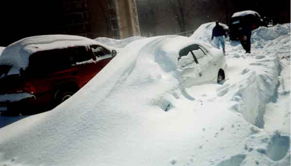
Analog Winter: 2002-2003: This winter was made famous from the Presidents Day Blizzard of 2003, where nearly 20 inches of snow fell in Philadelphia. Overall, the winter of 2002-2003 was remembered as being one of more snowy winters in recorded history. The El Niño during this winter was weakly moderate, and temperatures were actually below normal for the season!
These two analog winters had very different kinds of winters. This does not make it easy finding correlation and a pattern to base my forecast on. Luckily, other factors, like teleconnections, are important indicators during the winter that help forecasters fine-tune their predictions.
2. Teleconnection Strength: Multiple teleconnections, including the AO, NAO, and the PNA, will be crucial in determining the winter pattern. The Arctic Oscillation (AO), is an index which records the pressure anomaly in the arctic region. A positive AO usually means a warmer winter, while a negative AO usually signifies a colder one. Currently, the AO will stay negative over the next few weeks, which means the rest of November will be much colder than average.
The North American Oscillation teleconnection is an important indicator of the intensity of winter storms in the Northeast. Last year, we had a positive NAO, which limited the number of nor’ easters to just one. If the NAO turns negative this winter, there is a strong chance we will have a couple very large snowstorms, ones that will drop feet of snow.
The Philaburbia Weather Winter Forecast of 2014-2015:
After last year’s extremely cold and snowy winter, we will not get too much relief this year. Already, we are seeing temperatures way below normal for November and an AO that looks to be staying negative for the near future.
However, there are some indicators that the end of the winter could be warmer than last year’s. With a weak El Niño developing, there is a possibility that the Polar Vortex will retreat back north, which would cause our February and March to be much warmer.
In terms of snow, I think we are in for less frequent smaller storms and more large nor’easters than last year. I could easily see most of the snow falling this winter from 2 or 3 large nor’easters and nothing else. As a result, our area could see 30-40 inches of snow this year depending on how many nor’easters hit and how intense they end up being.
To recap:
1. Cold winter. February and March becoming warmer than average. Temperatures 2-3 below average in Dec and Jan. Temperatures 2-3 above average in Feb and March.
2. Snowy winter. Less smaller storms, more larger ones than last year. 30-40 inches of snow.
Thanks everyone! Stay tuned.
