
Hey everyone. It has been quite a while since my last post. Winter 2014-2015 has been fairly quiet and cold so far. According to reports, we have only received 1-2 inches of snow so far this winter. This is much lower than what we had at this time last year.
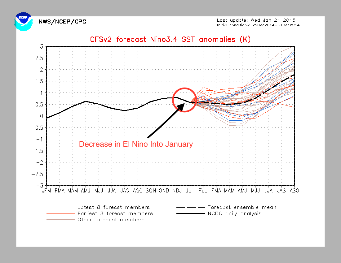
Temperatures this winter have been around average so far. December finished 4 degrees above normal, while January has been nearly 3 degrees below normal. This contradicts my original forecast, where I said January would be warmer than December. An explanation for this flip in temperatures lies in the El Niño strength over the past couple months. The Niño we’re currently experiencing decreased from December into January, this indicates why our temperatures have been colder in January compared.
In current news, I am currently tracking a winter storm during the day on Saturday. Analytical indicators have been favoring a large storm streaming up from the Gulf of Mexico and intensifying off of the Mid-Atlantic coast. While the setup for this storm is not perfect, I do believe a plowable amount of snow will fall north and west of Philadelphia.
The Setup
Current models have been showing less than ideal conditions for a major east coast snowstorm. The most major flaw in the pattern right now is the lack of a “Quebec high”, which tends to bring frigid Canadian air down and feed the cold side of the storm. There is also no indication of strong blocking ahead of the storm, which means that there is a chance that it could quickly run east of the benchmark. This ultimately means that we could have some mixing with this storm as well as a sharp cutoff in the amount of precipitation north and west of the city.
Let’s look at some of the models:
The European and North American Model (NAM) have been aggressive with the amount of moisture associated with the storm. They also forecast the storm further west than some of the other models. With both models, however, mixing will be an issue south and east of the city. While snow totals could be around 6-8 inches for Philadelphia north, in South Jersey snow totals may be limited to 2-3 inches at the most. This mixing issue, as I alluded to earlier, is from the lack of the Canadian high providing cold air for the strengthening storm.

The GFS model has been possibly underestimating the strength of the storm. As a result, it brings the track further out to sea, which diminishes snow totals throughout the region. A general 2-4 inches would be expected if the GFS solution was the correct one.

At this point, I am leaning toward the Euro and NAM solutions. The reason for this lies in the Arctic Oscillation teleconnection, which is one of the main indicators I use to determine the strength of a storm. As you can see from the graph below, the AO is projected to sharply become positive a day after our storm pulls through. Any time this happens, it tends to indicate a change in the upper atmosphere in the arctic circle, possibly caused by a major storm system. This metric has increased my confidence for a larger and stronger storm on Saturday.

I will have more updates as we get closer to Saturday. I will release my snow map Friday night.
Thanks everyone!
