
A major blizzard will affect most of the Eastern seaboard starting tonight into Sunday morning. This storm will rival the 1996 blizzard in terms of intensity and snow totals. Blizzard warnings have been posted by the national weather service for many areas, including Washington DC, Baltimore, Philadelphia, and New York City. This blog post will overview the storm in three sections: snow and timing, wind, and recommendations.
Snow:
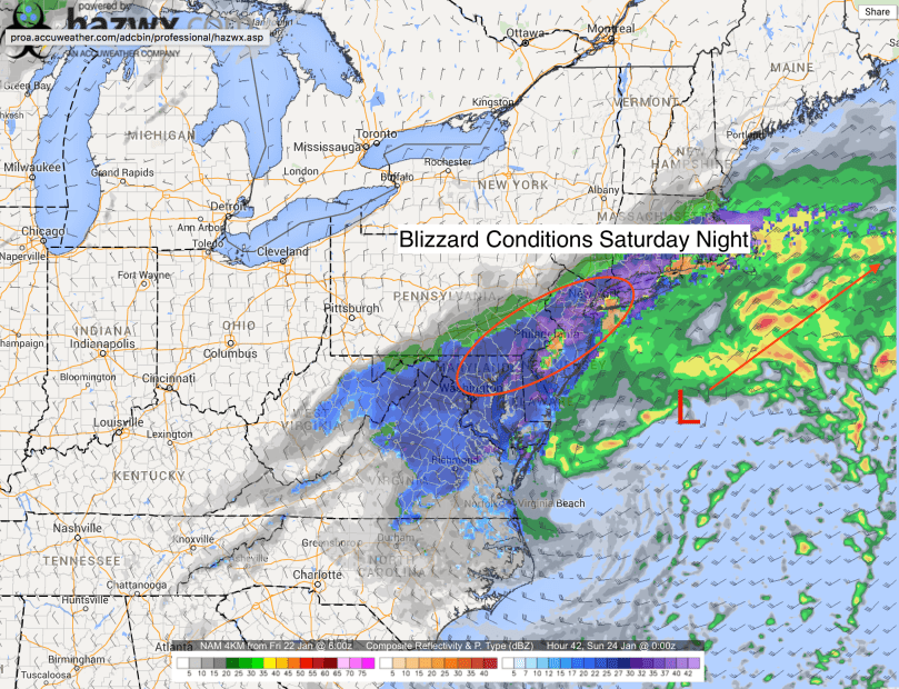
Currently, our storm is gaining strength in the southeast. Snow is currently falling in Virginia, Tennessee, and Kentucky. The low pressure is moving northeast and will exit off the Atlantic coast sometime Saturday morning. Light snowfall should start at around 10 PM tonight and progressively become heavier by Saturday morning. The image below of the 4K NAM shows steady snow moving into the region late tonight and early Saturday morning.  As the low pressure moves off of the coast, it will strengthen further and the the wind and snow will pick up during the day on Saturday. Snowfall rates of 1-2 inches an hour are very likely from 10 AM to 6 PM on Saturday as the storm moves into open water. The 4k NAM image below shows the snow in the area becoming heavy tomorrow morning:

As we head through the day Saturday, a lull is likely as the storm’s initial precipitation shield moves off the coast. This lull will occur during the afternoon or early evening on Saturday. By nighttime, the snow will pickup again and blizzard conditions will prevail until early Sunday morning.
 By Sunday morning, the snow should slow down and eventually end from west to east.
Totals:
Forecast models have projected snowfall totals ranging from 1 foot to over 2 feet. My forecasted totals are a blend of multiple models and are shown below:

As the snow map shows, we are in for a snowstorm of historic proportions. Areas in Virginia and Maryland will receive the most snow, with some totals approach 3 feet! Our area will likely see totals 1-2 feet with locally higher amounts.
Wind:
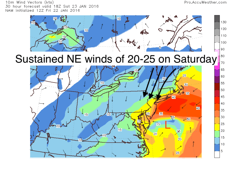
Heavy snow is not the only factor of this storm. As the storm moves offshore, it will strengthen and bring in strong winds from the northeast (that’s why they call it a nor’easter). These winds will be strong, cold, and straight out brutal. At the peak of the storm, winds will be 20-25 mph with gusts up to 40. Along with the snow, it will create whiteout conditions on Saturday and Saturday night. Visibilities will be almost 0 and temperatures in the upper 20s. Additionally, there will be blowing and drifting snow, which will make it extremely difficult to clear the roads on Sunday.
 Recommendations:
Please do not drive during this storm. With visibilities extremely low and heavy snow falling, travel will be nearly impossible on Saturday and even into Sunday. If you go outside during the storm, wear layers and make sure any exposed skin is covered. Travel will likely be limited into Monday as drifting snow and refreeze will cause issues early into next week.
Thanks all and don’t hesitate to comment with questions or concerns!

Thanks for this detailed analysis, Jason – very helpful!