
Following a very short January thaw, winter is returning this week with both ample cold air and a storm.
Clipper/Coastal Forecast
An Alberta clipper is moving down through the great lakes region and will phase with a piece of energy off of the Atlantic coast late Tuesday night. As the clipper moves eastward, it will bring a period of snow tomorrow evening into Wednesday morning for much of the region. Depending on the timing of the coastal phase, areas north and west of Philadelphia could receive substantial snowfall from this system. The map below shows the radar tomorrow at 7 PM. According to this model (the NAM hi-res), as the clipper begins to phase with the coastal low, a broad swath of snow enhances over Central and Eastern Pennsylvania:

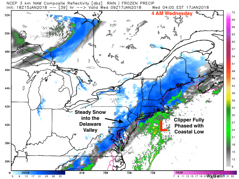
By early Wednesday morning, the phase is complete, with a full coastal storm strengthening off of New England. At this point, a wide area of heavy snow will form over New England and will extend down to Virginia:
As with many atmospheric phases, forecasting storms like this can be difficult. A slightly earlier or later phase would significantly alter the forecast for the I-95 corridor. Based on what I’ve observed from the forecast models, 5-8 inches will likely accumulate from the Poconos into New England. Most of the major cities, Philadelphia included, should receive 2-4 inches of light, fluffy snow.
Snow will likely begin after the evening rush on Tuesday in the Delaware Valley. In areas north or west of Allentown, I would advise preparing for a significant snowstorm tomorrow into Wednesday. Wednesday morning’s commute will likely be slick as the storm begins to move out.
