Meteorological Lesson #4: Fog


Here in the Delaware Valley, we are heading into our “fog season.” But why? Why are there so many foggy mornings in the Fall?

Firstly, fog is a type of cloud. It is the only type that forms at ground level. Fog can be particularly crippling to motorists as a result of its high water particle density, making visibility levels extremely poor.  There are many classifications of fog that form in different areas of the world. In our area, we, for the most part, experience radiation fog.

Radiation Fog

Radiation fog can only occur when:

1. The temperature and dew point (temperature for water vapor in the air to condense into water) are less than 4 degrees.

2. The humidity is 100% (meaning the air is saturated with water vapor particles)

And most importantly,

3. After a clear and chilly night

Clear and chilly nights (common in the fall) are crucial in the formation of radiation fog. Radiational cooling of the air occurs, lowering the saturation point of water vapor. When the air becomes cool enough, the relative humidity will eventually reach 100%. Then, if the dew point and temperature are less than 4 degrees apart, fog will form. Radiation fog will form before sunrise and end shortly after as daytime heating begins and the saturation point goes back up.
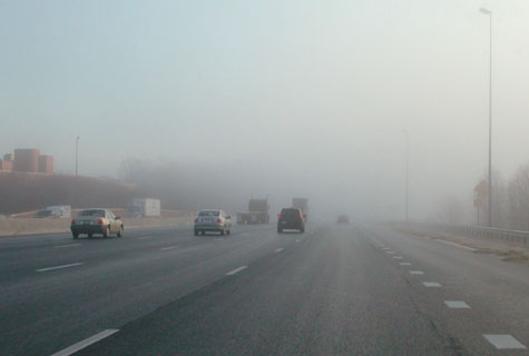
More Radiation Fog
Advertisement

Getting Cooler by the End of Week


Hi everyone. Some surprise showers and thunderstorms are scattered around the area tonight. These should die out by Monday morning.


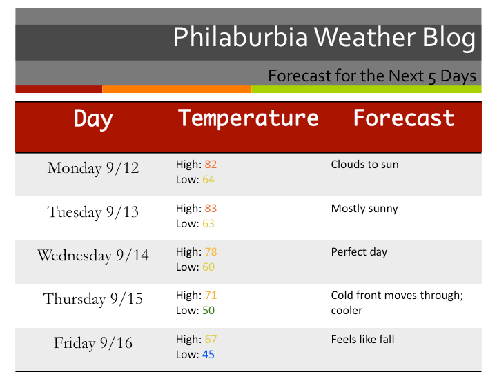
Well, I can officially say that we are done with the peak of hurricane season. Things should start to wind down in the tropics as the water temperatures lower and the pattern changes. Temperatures should be in the 80s for the first part of the week before a cold front moves through on Thursday. End of the week temperatures will be in the 60s with lows in the 40s. According to the long-range forecast models, we should head back into the 70s by  September 20th. The weather pattern will be calm for the next week or two as the recently chaotic pattern will finally slow down.

There does not look to be many more days in the 80s for the season, a sign that fall and winter are quickly approaching.  Enjoy this really nice stretch of weather, it may be one of the last before the cold arrives.

Five Day Forecast

Katia Should Head Out to Sea. Lee, Well That’s Another Story…


Hi everyone. It has been a little while since my last post. Firstly, I want to talk a little about Irene. I am sorry that I stopped updating during the storm, but I lost power for nearly 72 hours. I did have a generator, but my internet and cable was out for the whole time. By the time we got our power back Tuesday night, Irene was long gone and finished. What she left behind was devastating to the Northeastern United States. Irene caused billions of dollars in damage and nearly fifty deaths. In the Philadelphia area, millions of people were without power and many trees were down. New Jersey was hit the hardest, as widespread flooding and downed trees shut down most of the state. We will likely not see a storm like this for a long time. Irene will no doubt be remembered for generations to come.

Irene Hitting NYC

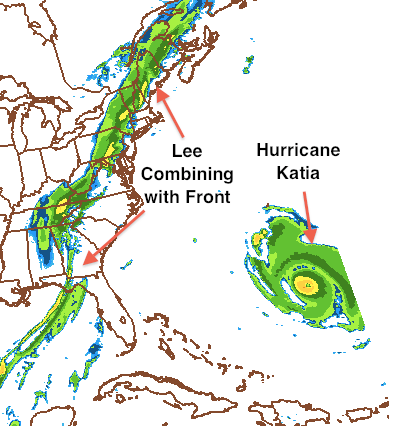
Now, for the current situation. Katia is presently a category 2 hurricane. She shouldn’t be any threat to land other than some high surf at the Jersey shore. Lee, on the other hand, will combine with a cold front and create a swath of moisture extending from the Gulf of Mexico to Canada. In our area, I would expect 2-3 inches of rain to fall by Tuesday night with locally higher totals. A Flood Watch is in effect until Tuesday night. The weather should clear up by late week as high temperatures will fall into the 70s.

Lee and Katia