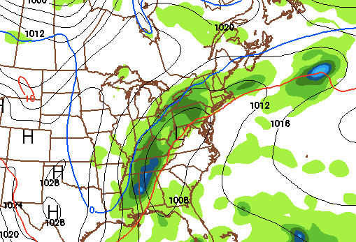
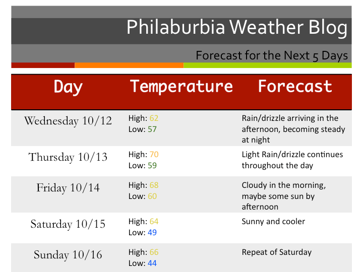
An Overview of the October Snowstorm of 2011


I have only one word to describe this storm: Shocking. Millions of people without power, combined with tree damage, will make this one of the most costly storms in October.

1. What Happened?: A nor’easter formed as expected in the Atlantic Ocean. The path of the storm was predicted correctly by the models and meteorologists alike. But, we did not believe that the amount of snow the forecast models projected to fall on Saturday would come true. Everyone assumed that it was impossible to have snow totals over a couple of inches in October. When I woke up Saturday morning, I knew something was seriously wrong.
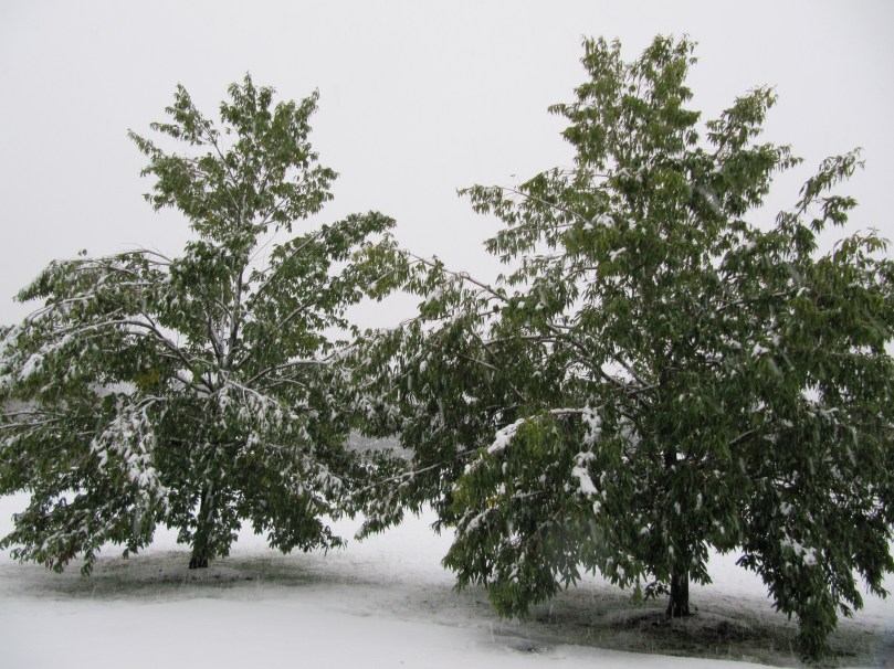
Snow on Trees with Leaves

I looked out my window to see snowflakes mixing with the rain falling. According to my forecast, I believed that the changeover would not happen until the late afternoon. But, by 11 AM, the rain had changed to all snow north of I-95. At noon, I had lost my power, which did not return until Sunday night. I watched in helplessness during the day Saturday as the snow kept piling up, breaking many tree branches in the process. By the time the storm moved out, there were over 2 million people without power in the Northeast.
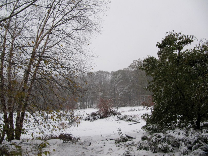
Picture of my Front Yard

Why did the changeover occur earlier? There was more cold air in place than expected during the time of the storm. As the nor’easter moved northeastward, it just brought in more cold air.

2. Effects: Peco announced that this storm was the worst October storm in their history. New Jersey is still under a State of Emergency as hundreds of thousands of people are still without power. Many trees were damaged during this storm, creating a lot of cleanup for households and local townships.

Another Storm Picture

3. Opinion: Okay, this is my rant portion of the post. Anger is probably the word that describes how I feel toward the National Weather Service in Mt. Holly right now. On Friday morning, they were calling for a coating to an inch of snow for the NW suburbs of Philadelphia. At that time, most forecast models were showing 4-10 inches of snow to fall in the area, and it seemed that a Winter Storm Watch would be necessary. But instead, they did nothing. The news stations then based their forecasts off of the NWS and their remarks. As a result, most people thought that this storm would be a minor one for the area. There were no salt trucks ready, and people were ready to have a fun Halloween weekend. By the time the snow started falling Saturday morning, the NWS was on it heels, realizing their fault. They raised snowfall totals 6 inches for the suburbs. 6 Inches!  My forecast of 2-5 inches for the NW suburbs, was not nearly as bad as the NWS. What baffles me is the fact that these people are professionals. How can an amateur like myself have a better forecast than a whole group of forecasters who majored in meteorology?

All in all, we learned a lesson from this storm. It really does not matter that we are in October. If cold air is in place and a nor’easter is riding the coast, snow will fall. This past storm will undoubtedly serve as a great precedent for any future October snowstorms in our area.

Advertisement

Updates for the October Snowstorm of 2011


WOW. I woke up this morning to a very alarming surprise. Snow was already mixing in with rain at my house in Bucks County. Temperatures are in the mid 30s throughout the region; much colder than what was forecast last night. This means that I may have to raise my snow totals for this storm. Most of the NW suburbs have changed over to rain with snow or all snow. Because we are just at the beginning of this storm, expect the snow to continue until late tonight.

The roads will be treacherous tonight. Stay home if possible. This is a major snowstorm we’re dealing with, and our area is not fully prepared for it. Many people will lose power for a time tonight as the snow accumulates on tree branches and power lines. I will update in a few hours on the latest.

Here is a live radar shot:

Snow Map and Final Forecast for the October Snowstorm of 2011


Its coming folks. The largest October snowstorm to hit the area in recorded history is starting to gain steam in the south as the trough begins to phase together. Right now we are dealing with two pieces of energy, one in the Atlantic and one over the Southeast. By tomorrow morning, these two disturbances will phase and explode, creating a massive nor’easter. Winter storm warnings have been issued by the National Weather service for Chester, Bucks, Montgomery County, and Hunterdon. While a winter weather advisory has been issued for Philadelphia, Delaware, Mercer, Camden, and Burlington counties.

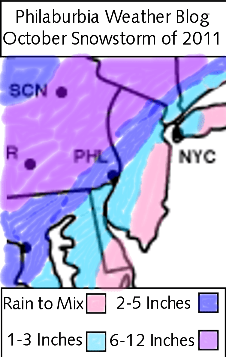
Now, here’s my snow map for this storm (explanation will come after):

October Snowstorm Snow Map

Okay, so these are my final totals. Right now, we still do not have the storm’s path nailed down. A small shift east will shift the 6-12 totals into our area, while a shift west will bring the 1-3 totals up.

This storm will not be all snow. It will begin as rain as moisture from the South starts to invade the area. By 2-4 PM, the rain will slowly change to snow as the cold air from the Northwest is brought in by the nor’easter. The key to the amount of snow we receive will be when the changeover to snow occurs. Unfortunately, I, nor any other Meteorologist will be able to pinpoint this time down until it happens. By 8 PM, wet, heavy, snow will be falling north of Philadelphia, weighing down tree branches and power lines. By 4 AM Sunday, the snow should be moving out. Power outages will be major from this storm. Numbers could be in the range we had for Hurricane Irene. Some people, especially to the north, could be out of power for days. The problem for this storm won’t be the roads, but more the tree branches blocking the roads.

Snow Totals: Near the coastal regions, I just do not see the rain changing over to complete snow. From Philadelphia to its immediate south and east, we are looking at 1-3 inches. In the NW suburbs, 2-5 inches will fall. In the Lehigh Valley, Poconos, and Susquehanna Valley, 6-12 inches will fall.

Final Thoughts: Please be careful on the roads Saturday night! Tree branches will be down all over the place. By Sunday, it will look like January in the area. Halloween will be chilly, and there could be still snow on the ground in the NW suburbs. Enjoy trick or treating in the snow, as it may be a while until we have snow on Halloween!

Major October Snowstorm Coming Saturday


The situation for Saturday’s storm has taken a complete 180 from yesterday night. Models have suddenly switched to scenario 2, a major nor’easter.What we are looking at is an extremely rare event. We have received accumulating snow in October only three other times in recorded history.

Many of the models are showing a snowstorm that almost looks like it belongs in the middle of January. Because we are in October, the snow totals won’t be extremely high. However, the snow will be heavy and wet. Only 4 inches of heavy wet snow can cause widespread power outages across the area. I recommend to start to prepare for power outages that will last for days in some cases.

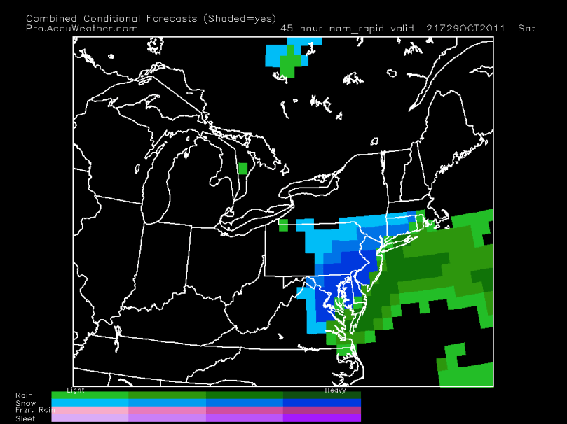
Here is the NAM model showing heavy snow (blue color) 5 PM Saturday:

NAM 5 PM Saturday

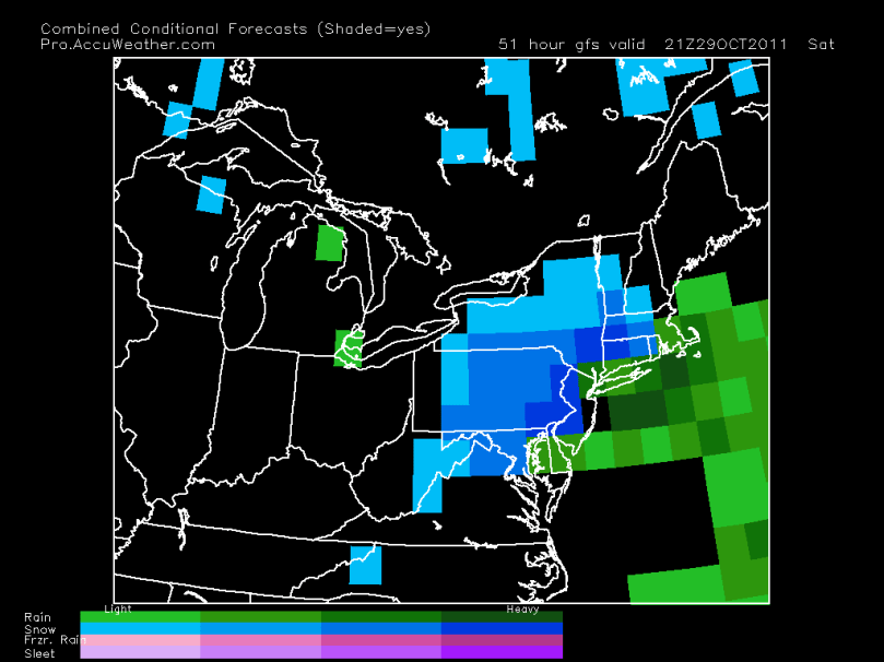
Here is the GFS model showing heavy snow 5 PM Saturday:

GFS model 5 PM Saturday

How much snow?: I am currently thinking a general 2-5 inches for Philadelphia and 3-7 for the NW suburbs.

Timing: Precipitation will start Saturday early afternoon as rain. By late afternoon or evening (depending how close the nor’easter is to the coast), the rain will slowly change to heavy, wet snow. Snow should continue to fall until 1 AM Sunday before tapering off.

Snow Map: I will post a snow map tomorrow afternoon

Bust Potential: There is a high bust potential for this storm. Because we are dealing with near freezing temperatures in October, the changeover from rain to snow may be later than originally thought.  There is also a small chance that the storm brings in warm air by taking a more westerly path. This scenario would undoubtedly bring down our snow totals.

In review, we are looking at a major snowstorm this Saturday that has a potential to cause widespread power outages and disruptions. Snow totals will range from 2-4 inches if the nor’easter takes a westerly path, and 4-8 if the storm takes a more easterly path. I will have more details tomorrow.

October Snow Update; Leaning Toward a More Minor Event


The forecast models have finally started to agree with each other. At this point it is looking like the storm will skirt the region. It is not looking like we will get a major amount of snow/rain from this storm. As with any storm, situations tend to change in an instant. We are dealing with complex tropical system (Rina) in the Atlantic, and it’s October.

The timeframe of this storm has not completely been ironed out. If the storm turns into a full-fledged nor’easter, we would have rain Saturday morning and afternoon followed a period of snow Saturday night. If the storm goes further east and does not strengthen, we are looking at a period of rain Saturday night followed by a brief burst of snow.

Here is the GFS model, showing a weaker nor’easter. Rain followed by a brief period of snow is expected from this particular scenario:

Weaker Nor'easter

There will not be much snow accumulation from this storm, even if we receive a longer period of snow than expected. The ground is too warm, the ocean is too warm, and the current angle of the sun does not support accumulation. As for totals, I am currently thinking a coating to an inch on grassy surfaces. If the nor’easter is stronger than expected, then a general 1-3 inches of snow could fall.

More to come tomorrow

Predicting Snow in October… Not an Easy Feat


The last few days have been demanding for weather forecasters across the country. October snowstorms are very hard to nail down. Because of their rarity, meteorologists do not have much history to base their predictions off of. This has been the case for our possible nor’easter on Saturday.

Here is how things should pan out until Friday:

A cold front will pass through our area Thursday. Around an inch of rain should fall from this system. After the cold front moves through, it gets complicated. Hurricane Rina (currently in the Caribbean) will start to head toward Florida as the jet stream starts to influence its path. At this point, there are two scenarios (surprise surprise) that could happen.

Scenario 1, Out to Sea – Rina stays strong and does not phase with the jet. Sunny day for the Delaware Valley on Saturday. No nor’easter. This scenario is supported by a few forecast models, including the famous GFS.

Scenario 1: Out to Sea

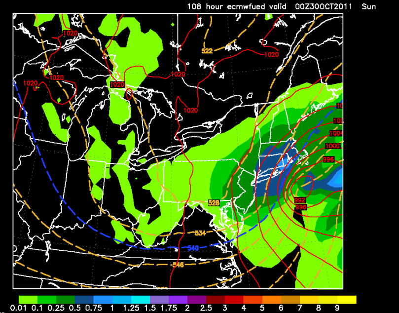
Scenario 2, Snowstorm – Rina weakens and phases with the jet, bringing in cold air and becoming a large nor’easter. This solution would likely bring accumulating snow to our region. As of right now, I am leaning toward this scenario. The forecast model supporting this scenario is known to be the most accurate.

Scenario 2: Nor'easter. 8 PM Saturday

Truthfully, I really have no idea what will happen this Saturday. There have not been many October storms to base this prediction on whatsoever. The number of factors involved, combined with the unpredictability of Atlantic tropical systems just adds to the confusion.

As we progress through the week, one of these scenarios will become more and more favored. If the models have complete consensus on scenario 2, then I will proceed to make a snow map as soon as possible. If scenario 1 looks more likely, then I will  issue a five-day forecast. I will update tomorrow with the latest.

Seasonable Weather Before Cold Moves in Next Weekend


The title says it all. We are going to have a few nice, seasonable days as high pressure sets up to our southwest. After a rainy first part of the week, this nice stretch of weather will be a pleasant break.

Of course, the weather will not stay nice forever.

I am currently tracking a major cold front sweeping through the area at the end of next week. This front will bring in arctic air behind it and plunge temperatures into the 30s. There is a small chance that this cold front phases with the jet stream and turns into a Nor Easter. With this scenario, we would receive rain with some back-end snow as cold air is rapidly brought in behind the storm. At this point, this solution is unlikely. I am sure we will have our first frost next weekend, as well as highs in the 40s for a few days after the front pulls through. After this cold stretch of weather, temperatures should rise to more seasonable levels.

Here is the GFS model 247 hours out (Friday October 28th midnight). The blue line represents the rain/snow margin:

Cold Front Next Friday


Rain, then Chilly Weather. Real Cooldown will Come Late Next Week


I hope everyone enjoyed the perfect weather we have had over the past week or so. It’s been over a month since we were seven consecutive days without rain. This pattern will change quickly tomorrow into Friday as a tropical disturbance will push up into our region. I’d expect a total of 1-2 inches of rain to fall, nothing out of the ordinary for a fall rainstorm.

What is starting to intrigue me is in the long-range. A few forecast models have been showing low temperatures below freezing late next week as a high sets up to our southwest behind a cold front. Some places in Central Pennsylvania could even see some snow flurries or some backend snow from the cold front next week. This chilly spell is just  another sign winter is quickly approaching.

GFS model showing below freezing temps (Blue line is 32 degrees)

I will try to release my winter forecast on the 22nd or 23rd of October.

Here’s the five-day:

Five Day Forecast

Getting Warmer by the Weekend; Tropical Rains Next Week


Our stretch of nasty and chilly weather has finally come to an end. High pressure will set up camp southeast of the area and bring in unseasonably warm air this weekend continuing into next week. Latest model guidance has been showing a weak tropical system dropping a significant amount of rain on the Delaware Valley. The timeframe of this storm will be Wednesday or Thursday of next week. I will continue to monitor this situation.

Over the last few weeks, I have received a few inquiries about the upcoming winter. I am still waiting to see how the pattern will set up later in the month. As of right now, it looks to be a snowy winter with the La Niña (cooler Pacific temperatures) projected to shift to an El Niño (warmer Pacific temperatures). Historically, winters where this transition takes place are snowier and colder than average. I will issue an official forecast later in the month.

Here is the five day forecast:

Five Day Forecast

Lastly, this September was also the third wettest September on record. By the end of the year, we will most likely break the yearly rain record.