A Tricky Forecast for the Upcoming Snowstorm on Saturday


UPDATE: 3:45 PM Friday

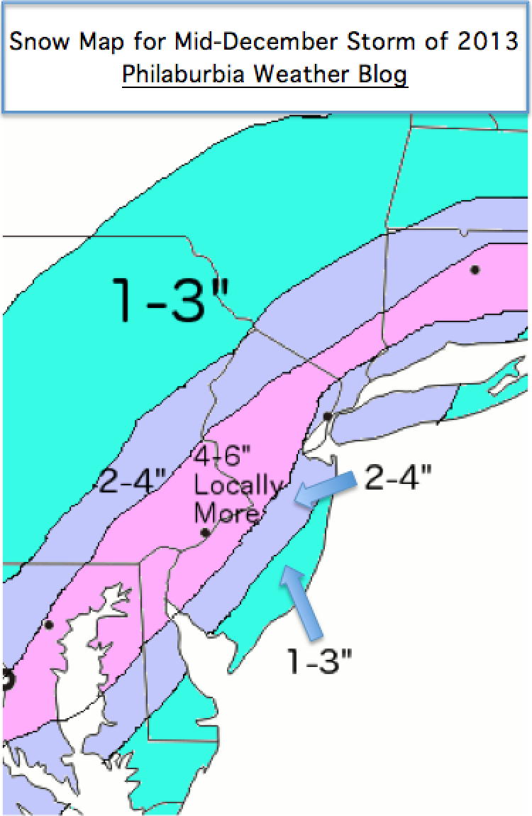
No significant changes in my forecast for tomorrow. There has been some model waffling, however, which shows that there could be a few surprises tomorrow when the storm arrives. I am sticking with a general 2-4 inches in the Philadelphia metro area with higher totals further north and west from the city. The snow should also turn to a mix in most areas by late Saturday night.


Hey everybody. Well, another fairly large storm will affect the area on Saturday! The question that remains, especially for the big cities along I-95, is what precipitation type we will receive.

A low pressure system will move through the midwest tomorrow before transferring to the coast sometime on Saturday. The problem for many models and forecasters alike is determining when this transfer occurs. An earlier transfer means more cold air will be brought in behind the storm, meaning more snow for our region. A later transfer means that more warm air will move in aloft and at the surface, meaning more mixed precipitation for the region.

Split Screen GFS
Split Screen GFS

All models are in a general consensus, but with a storm like this, small changes mean large differences in precipitation type. Snow will move in around Saturday 3 PM and continue into the night. Depending on when the transfer occurs, the snow will change over to a mix for areas around I-95 by midnight on Sunday. This changeover to mix could happen later or not even occur if the storm transfers earlier.

Right now, I am taking a conservative approach toward this system. I am calling for 1-3 inches for areas along I-95 with the cutoff being very sharp as one heads further north and south. Allentown could receive 6-8 inches while Doylestown could only receive 1-3. Here is my snow map for the upcoming storm, enjoy!

Snow Map for the 2nd December Storm of 2013
Advertisement

After a Surprise Snowstorm Yesterday, Another Snowstorm is Coming Tomorrow!


Wow. It was quite the day meteorologically yesterday. After many forecast models were showing minimum snow falling in the Delaware Valley, Philadelphia International ended up with 8.6 inches of snow. Many areas to the south and west of the city received 4-8 inches of snow with some isolated totals nearing a foot! Unfortunately, many people were not expecting a major snowstorm to occur. As a result, many accidents were reported on major roadways. December can be a very tricky month to predict snowstorms, as we are still transitioning to a classic winter pattern.

Nice Shot of the Snow Yesterday
Nice Picture of the Snow Yesterday

Another, more predictable snowstorm is in the works for tomorrow. The system is a weak piece of energy associated with the trough that is pulling through the area as we speak. The snow will be short and intense.  The snow will start around 9 AM on Tuesday and end by 7 PM on the same day. In localized areas, snow could fall at an inch or two per hour.  The tricky part of this forecast is determining the exact position of the trough when the moisture runs the coast. Unfortunately, this part of the forecast is subject to “nowcasting”, which means it is impossible to predict which areas will receive the most snow until the storm is actually occurring.

GFS Solution Tuesday Afternoon

Luckily, most models are in agreement that we will receive a general 3-6 inches in the Philadelphia metro area, with lower totals in the outskirt suburbs. Temperatures should hover around 32, and roads should be salted before the storm arrives. A Winter Storm Warning has also been released by the National Weather Service for the whole I-95 corridor.

With that said, here is my first snow map of the 2013-2014 winter. Enjoy!

Snow Map for Mid-December Storm of 2013

Another storm is on-deck for early next week, so stay tuned!