Meteorological Lesson #2: Low Pressure


Lesson Number 2: Low Pressure

I decided to focus on Low Pressure systems for my second lesson. For the most part, when people hear “low pressure”, they generally associate it with storminess, Nor Easters, snowstorms, hurricanes, and cold fronts. All of the previous listed occurrences come from a low pressure system.

Low pressure systems are generally more complicated than high-pressure systems. They are actually the polar opposite of high pressures. Low pressure systems are areas of counterclockwise circulation where the pressure at sea level is lower than the actual Earth pressure (29.92 inHg). Usually a low pressure system is connected to a cold front spreading to the south and a warm front spreading to the east (see map). As I said before, a low pressure system always means cloudy, rainy, and/or snowy weather.

The Low Pressure System

In a low pressure area, warm air coming from the south rises and cools. This cooling causes cloud formation and eventually the clouds become dense enough to produce precipitation. The lower the pressure, the more precipitation that will be associated with the system, hence the reason why hurricanes are so expansive.

I want Nor Easters and Hurricanes to be their own separate lesson, but I’ll talk briefly about them here because of their relation to low pressure systems:

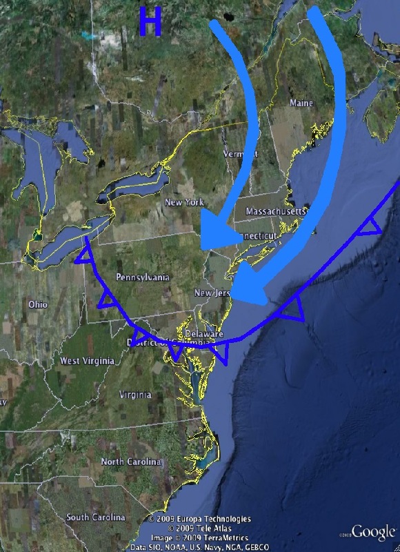
The reason why a Nor Easter gives us snow is that all the moisture from the warm front in the ocean is brought around the storm and ultimately comes from the northeast, mixing with the arctic air and giving us a major snowstorm.

Here is a simple map of a Nor Easter:

Nor Easter Map

Hurricanes:

A strong hurricane forms and strengthens over warm water. This is because as the low pressure is moving west, it gathers moisture from the warm air and ocean. This moisture continues to circulate around the system as it keeps moving, causing something like the snowball effect. Eventually cyclogenesis occurs and the low pressure starts rotating around itself. I will talk more in detail about this phenomenon in the hurricane lesson.

Here is an example of the amount of moisture a hurricane can make during its trek across the Atlantic:
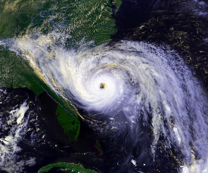
hurricane Hugo Expansive Moisture
Advertisement

Two Nuisance Storms on Two Consecutive Days


The computer models are finally in agreement for the next “double barrel” storm. At this point, it is looking that we’ll get 1-3 inches of snow later tonight into tomorrow morning. Roads should be fine because of the warmer temperatures we’ve had recently. There is a Winter Weather Advisory for Philly northward, but I believe road conditions will be perfectly fine tomorrow morning.

The storm after that could be a little more unpredictable. As of right now it is looking like another 1-3 inches Tuesday morning. Again, nothing serious and the roads should be decent enough to travel on. I am concerned that the second storm could have precip more north than the models are projecting. With that said, I will not let my guard down for the second storm. I will keep checking ever run to see if any changes have ensued.

Just a note on the Meteorology lesson: I will be talking about low pressure systems after the storms coming up (AKA Tuesday).

And finally some long-range input for anybody who’s curious about whats coming up in the weather:

1. After the double trouble storms, temps should rise. A soaker is looking possible on Friday (2/25) with a change to snow at the end

2. March 1-3: This is the next chance for a snowstorm. I am getting the feeling that this could be our last real storm until spring.

3. After March 3rd temperatures should stay below freezing.

After Record Warmth, Temps will Drop 35 Degrees by Tuesday


I hope everyone enjoyed the warmth we got today. I actually had the window open in my car driving today! Many records were broken with the highs reaching 72 in Trenton and 69 in Philly. A cold front will sweep through the area tonight and lower the temperatures by 20 degrees.

THEN… it gets complicated. A storm system will pass to the north on Sunday giving us occasional showers. After that nuisance system passes it gets really complex. Another storm will follow it on Tuesday. Its placement actually depends on a trough in the west and how far west it will be sitting during the storm.

Models are all over place right now and details are a little vague. I’m leaning toward a more snowy solution but anything could change right now. A general 3-6 inches should be the maximum for the Tuesday storm. A minimum looks to be 1-3, so we’re looking at some snow. Another problem is, as we’ve seen before all season, that the storm will pass right during the morning rush on Tuesday. Even if we get only 1-3 inches, the morning rush will be nasty.

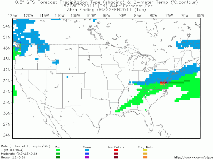
Here’s a map of the snow at 1 AM Tuesday Morning:

Snow on Tuesday Early Morning

Temps will be in the 30s on Tuesday, a 40 degree drop from today. Truly amazing.

Temps will rise at the end of next week, then it should get cold and stormy for the beginning of March. Still some winter to go!!

Meteorological Lesson #1: High Pressure


For the rest of the winter into spring and summer, I am introducing weather lessons for anyone who is curious about the weather and how it works. I am hoping that by next winter, most weather terms will be covered and described. I hope to educate my readers and myself about the weather and its inter-workings.

Lesson 1: High Pressure

High pressure is a term many of you have probably heard of on the news. It is generally associated with dry, cooler, and sunny weather, but there are certain exceptions. Without high pressures in the atmosphere, there wouldn’t be many dry and sunny days!

But what really is a high pressure? It is where the pressure on the surface of the earth is greater than the surrounding environment. The high pressure part, therefore, only describes what is going on at the surface compared to the atmosphere above. High pressure is usually an area of clockwise rotating winds surrounded by a hypothetical center marked  with a H.

Depending on where the high pressure is determines our weather. If we have a “Bermuda High” (high pressure over the Bermuda area), we get warmer temperatures because of the southerly winds coming from the clockwise spin of the high.

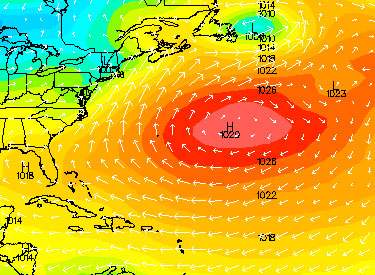
Here is an example of a weaker Bermuda high (high is east of Bermuda), notice the arrows from the south coming upward:

Bermuda High

A high to the west of our area generally brings in the colder air, thus giving us the perfect setup for snowstorms. The perfect placement of a high pressure system for a snowstorm is in Quebec, where the winds come in from the north. The reason why the last storm (the ice storm) didn’t have enough cold air aloft was because the high was stuck up in southern Ontario, giving us a westerly flow instead of a northerly one.

Here is an example of the Quebec high setup:

High Pressure in Quebec

I will have another Meteorological Lesson next week, this time talking about low pressures. 5 day forecast to come on Wednesday or Thursday.

Thursday Storm Bites the Dust; Warmer Temperatures Coming!


Hi everyone. I just wanted to apologize for the over hype for the Thursday storm. I had many people come up to me today and ask how much snow we’re getting on Thursday. The fact is, we’re probably not getting any snow on Thursday. The trough in the east has flattened out to sea. The trough is the path a storm takes when it moves west to east. A sharper trough means a storm riding the coast; a flatter trough means a storm is out to sea. All computer models are showing a flattened trough on Thursday which means the storm will be likely suppressed out to sea. I’d expect a partly cloudy day Thursday with below average temperatures.

I also wanted to talk about switch in the weather pattern next week: Temperatures will rise next week as the La Nina we’ve been waiting for all winter finally shows its face. By next Wednesday, I’m guessing any snow on grass will be gone. There will be a break from any storms, rain or snow, for the next 10 days or so.

This break in the pattern gives many weathermen and enthusiasts a well deserved break. Of course just because it will get warmer next week doesn’t mean winter is over. Cold weather should return in late February and early March as Old Man Winter fights his last fight. For the snow lovers: Your time has ended until late February. For the warmer weather lovers: enjoy the next week and a half!

I am going to try to have some newer features this week to compensate for the lack of storminess. I will be reviving my 5 day forecast and will be having more “day-to-day” forecasts instead of “storm to storm” ones. A “this day in history” feature may be started sometime this week as well.

Late Friday Update: We Got a Big One Coming Next Thursday


I have two things to talk about in tonight’s post:

1. The National Weather Service has posted a Winter Weather Advisory for the area into tomorrow. This is a little too over the top in my opinion. There will be little if any snow, and the amount of freezing rain that falls will quickly be melted by a changeover to rain. Tomorrow will be a pretty nasty day however, so don’t expect to soak up and sunbathe in the winter sun…

2. Alright. I promise all the people who can’t wait till Spring that next Thursday’s storm will be the last for a little while. However, this storm coming next Thursday could be the biggest one yet this year. From the looks of a few select models I’ve reviewed, the setup will be a northern and southern jet phase that will ultimately culminate in a big storm riding up the east coast. Unlike the last few “slop” storms, the one coming up will have plenty of cold air to work with.

Because we are still 6 days out, the classic “model waffling” is occurring. The European is showing the big storm, while the gfs model isn’t anymore. This lack of consensus will continue until probably 54 hours out. This means I will hopefully be ready to post a snow map by Tuesday night or Wednesday morning.

I will have another post tomorrow with an update…

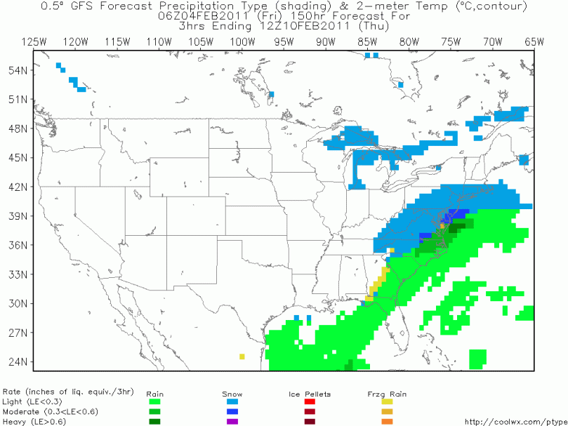
And of course a graphic of the storm Thursday:

GFS model of Thursday's storm

Review of the Ice Storm; More Storms Coming Saturday, next Tuesday, and next Friday.


One of the worst ice storms in the past decade hit the Philadelphia suburbs this morning as 1/3-2/3 inches of ice fell in most places. The storm didn’t have any huge surprises, luckily, and left the area in the mid-morning leaving a foggy mist to invade most places. All schools were delayed or closed, and travel was fairly treacherous on the side roads until the afternoon when temperatures had risen above freezing.

Tomorrow, there will be very bad refreezing. Temperatures will fall way below 32 degrees tonight and any wet surface will turn into an ice slick. I have a feeling that most schools will be delayed tomorrow to give buses and temperatures time to rise in the morning.

Saturday we have another storm coming. It is looking like a snow/ice mixture for places north of the city and a wintry mix from the city south. Then Tuesday we have another system coming. Details aren’t really clear for this storm, but as we get closer I’ll make sure to keep you posted. Tomorrow or Friday I’ll talk a little more about Saturday.

3rd on my agenda for today’s post is Mr. Punxsutawney Phil and his winter prediction. As many of you know, Phil called for an early spring. Even though it sounds insane, I going to have to agree with the groundhog. Temperatures are looking to rise in Mid-February as the real La Nina tightens it’s grip. And on my snow day on Groundhog Day I watched the movie, Groundhog Day!!! Great and hilarious movie; if you haven’t seen it, I recommend watching it when you have some time.

Lastly, here are some EPIC pictures of the ice this morning:

An Icy Morning
Ice Coating a Branch

The Final Forecast for the Ice Storm (Updates will be posted on this entry)


Ice totals are going to have to be raised throughout the area tonight. Temperatures have stayed in the 20th in the suburbs throughout the day today. They will stay below freezing until mid-late morning tomorrow. This means a longer period of freezing rain and more ice. Roads will be terrible until midday tomorrow and there will be widespread power outages, especially in the northern parts of the area. I have a feeling many people won’t even be able to get out of their driveways.

Also, if you have a car that is left outside tonight, be wary that .4 – .7 of an inch of ice will accumulate on your vehicle. If possible, try to put all cars in a garage to save alot of time tomorrow morning defrosting.

Schools will be closed tomorrow if everything goes as planned (meaning temperatures will stay below freezing into mid morning). There is always a chance for a bust in the forecast, just like this morning. Ice storms are particularly hard to forecast because of their involvement with both the upper and lower atmosphere and their respective temperatures.

We have another storm coming Saturday which could once again give us a wintry mix. When will this winter end?

AND here’s the live radar as always (note that this radar is going to have trouble interpreting between a wintry mix and rain):

Live Radar