03/27/10: A Chilly Weekend Followed by More Rain


Temperatures dropped into the 40s today as a low pressure system passed to our South. High pressure will prevail to our north while bringing in the cold Canadian air. By Monday however, another storm system will once again pass over the region and turn into a coastal system giving the coverage area a decent soaking. There is a flood watch also in effect for the region until Tuesday afternoon. Things finally look to clear out by the end of next week.

Forecast!

Tonight: Mostly Clear and cold Low 33

Tomorrow: Becoming cloudy by the afternoon; a little warmer Hi 54

Tomorrow Night: Rain moves in during the overnight hours Low 47

Monday: Heavy rain throughout the day, heaviest during the midday hours; slowing down by evening Hi 57 Low43

Tuesday: Rain picking up in intensity after 4:00 AM. A steady rain will continue throughout the day and finally end for good by the evening Hi 56 Low 39

Wednesday:  Finally clearing out! Hi 58 Low 40

I know I haven’t posted an image in a little while, so I decided to post one for the amount of precipitation over the past 30 days and how it compares to average. Please note that these rainfall totals will change dramatically after Monday & Tuesday’s rain.

Total precipitation from past 30 days

Advertisement

The Forecast is Back with Some Rain on Friday


I am finally back home from sunny (and cool) Florida. Temperatures will warm up for the next few days as high pressure dominates the area. The weather, however, will go downhill on Friday as a cold front (we’ll be seeing many of these throughout the next 5 months!) passes through out area and cools the temperatures down into the 40s! After the cold front moves through, another nice weekend will follow with highs in the mid 50s.

Here is the forecast:

Today: Mostly sunny and breezy Hi 64

Tonight: Clear skies and a little breezy Low 39

Tomorrow: Almost a repeat of Wednesday, just without the wind Hi 64 Low 43

Friday: Becoming mostly cloudy and cool Hi 48 Low 34

Saturday: Mostly cloudy skies in the morning will give way to partly cloudy skies by afternoon Hi 53 Low 36

Coming later on: More on the Friday cold front

Getting Warmer with a Chance of Rain


The temperatures are rising with every passing day. Yesterday we made it up to 64 degrees, one of the warmest days that we’ve had in a while! The next chance of rain will be on Sunday into Monday as a low pressure passes through the area. After Monday temperatures will plummet then recover as the week progresses.

Forecast:

Today: Mostly sunny and warm Hi 68

Tonight: A little chilly, but otherwise a great night Low 44

Tomorrow: Even warmer with hi’s reaching into the 70s in some spots! Hi 70

Tomorrow Night: Clear and chilly Low 46

Saturday: The warmest day since October!  Hi 74 Low 50

Sunday: Mostly sunny in the morning becoming mostly cloudy by nighttime with a chance of rain Hi 70 Low 54

Note: I will be in Clearwater, Florida for the next 5 days for vacation. I realized that the hi on Saturday is nearly the same as the hi in Clearwater! AMAZING.

I will try to report some info about the next storm over the next few days!

Get Ready for a Warm Week!


Take out your t-shirts and shorts and enjoy the warmest weather of the year coming up. Highs will make it into the mid 60s by Thursday and by the weekend could reach 70 degrees! Sunny skies will prevailfor the next week as high pressure dominates our area and brings in the warm air from the south.

Now here is the forecast:

Tonight: Partly cloudy skies in the morning, becoming sunny by the afternoon. Low 37

Tomorrow: Getter warmer and sunnier Hi 58

Tomorrow Night: Clear and pretty cold Low 39

Wednesday: Sunny and even warmer Hi 61 Low 40

Thursday: Sunny and EVEN warmer Hi 63 Low 44

A Soggy Next Few Days in the Works


Update at 10:00 AM Sunday: Well, I was awakened this morning to a pleasant surprise: a thunderstorm. As I said before, there could be a few rumbles of thunder with this storm. It is still shaking at my house right now and steady rain is falling. So far the rain totals have been high: 2-3 inches so far around the area. We will see a few more of these isolated rain blobs with thunder move through today before the whole thing moves out by tomorrow.

Update at 10:00 AM:

Well, most areas have been getting a steady rain throughout the night. The winds are howling and its only going to get worse throughout the day. Widespread flooding of the smaller creeks and streams looks likely and possible for the major rivers. The storm will start to wind down tomorrow morning and will be out of here by tomorrow afternoon.

Get ready for the biggest soaker since fall this weekend. If you like staying inside and watching TV (NCAA BB conference tournament!) then this is the weekend for you. There is a flood watch already out for the area and its looking to be a widespread 2″-4″ inches of rain.

When will it be the heaviest: After looking over the latest models, the heaviest rain will fall Saturday afternoon into the evening. An occasional rumble cannot be ruled out Saturday night as well as a result of the arctic air clashing with the warm air.

Will there be widespread flooding in the area: Well, the highest rain totals should be down in South Jersey with lesser amounts the more north you go. Most of the area rivers flow from North to South and usually flood when areas likes Scranton and the Poconos get more rain then we do. I think a few minor rivers will flood, but the major ones (Delaware, Schuylkill etc.) will probably just swell up.

Can you give us the radar image of the storm as it passes through the area? Sure! Here it is:

Forecast for Tuesday March 9th and Rain-Map


Hello everyone! It has been a very boring time for weather lately. There is one thing to be excited about which are the unseasonably warm temperatures lately. I am calling for temps in the 50s for most of the week. There is a rainstorm coming up Saturday with the potential for flooding, so watch out for that. Most of the main snow is already gone and we’ll probably not see the white stuff until next winter 😦 In a few weeks, I have a feeling severe weather season will finally start up!!

Tonight: Clear for most of the night. Fairly chilly Low 33

Tomorrow: Warming up nicely by the afternoon. Sunny. Hi 58

Tomorrow Night: Clear in the early evening, becoming partly cloudy overnight Low 37

Wednesday: Partly to mostly cloudy. Hi 60 (if sun stays out in afternoon) Low 43

Thursday: Mostly cloudy throughout the day Hi 54 Low 44

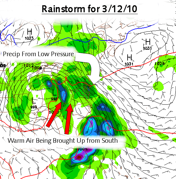
Anyway, here is a map I made for the next storm coming later this week:

Rain Map for 3/12/10

A Nice Couple of Days Coming Up


The pattern is finally starting to improve and I believe we probably have one or two storms to go before severe weather starts around here. The first one will be on Thursday or Friday of this week. The second one is a little more of a mystery, but it’s looking to be coming next Wednesday the 17th. The next few days are going to be great… go outside and run around, because it may not get this warm for a little while.

Here is the forecast:

Today: Sunny and mild. Great day to go outside! Hi 49

Tonight: Getting very cold at night; clear Low 29

Tomorrow: Ever warmer and sunny Hi 56

Tomorrow Night: Clear and chilly… make sure that you wear  a coat this night Low 30

Monday: Another beauty; a few more clouds than there were during the weekend Hi 55 Low 34

Tuesday: Finally getting more seasonable for this time of year. Mix of clouds and sun Hi 48 Low 32

Forecast and Scheduled Warm Up (50 Degree +)


I finally have some time to post something about the current weather. I felt like I did a good job not making a map for the storm that is currently moving through the area. It is just too warm outside and even if it did snow, it wouldn’t stick to any surfaces. The upcoming weekend is looking “balmy” for this time of year with highs most likely in the 50s. Most of the snow (excluding the parking lot piles) will be all melted by next Tuesday. The next chance of some sort of rain will be next Wednesday and then another chance on the 17th of the month. The active weather pattern is finally slowing down and spring is approaching fast!

As springtime rapidly approaches, we will start to look at severe weather and Hurricanes. I will post my hurricane forecast later this spring (it looks to be a pretty active year) and I will be posting severe weather analysis before, during, and after any chance of a thunderstorm. Just because it isn’t going to snow until next winter doesn’t mean the weather is useless! REMEMBER TO KEEP VISITING THE BLOG DURING THE SPRING AND SUMMER MONTHS!

Now for my forecast:

Tonight: Rain and/or mix starts to move out by 3:00 AM.  Low 33

Tomorrow: Seasonable for this time of year Hi 42

Tomorrow Night: Partly cloudy to clear (watch for black ice) Low 30

Friday: Sunny skies and a little warmer Hi 44 Low 32

Saturday: First day in the fifties since mid-January Hi 50 Low 36

Forecast for Tuesday March 2nd


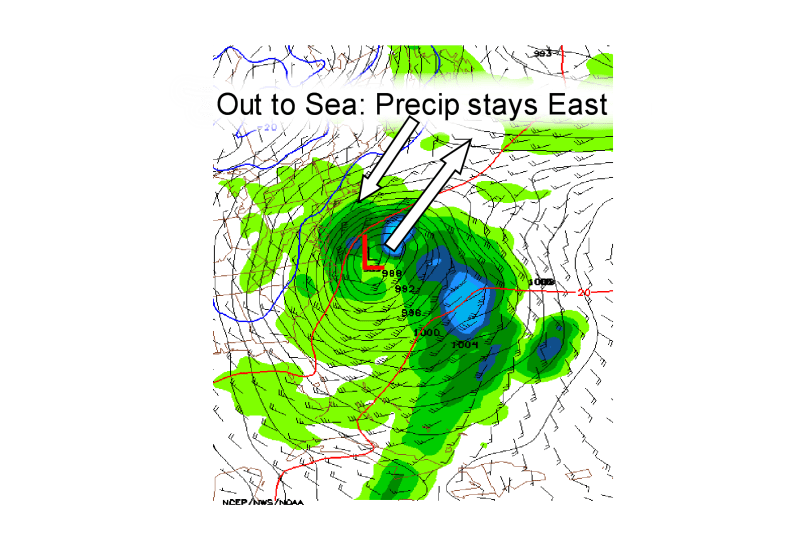
The storm on Wednesday isn’t looking great… I will maybe post a snowfall map tomorrow night if I have time. The storm is consistently going out to sea on the models and unless some amazing change occurs, nothing will happen….

Tonight: Becoming partly cloudy overnight. Lows are below freezing, so watch for refreeze Low 29

Tomorrow: Becoming mostly cloudy by the afternoon. Hi 44

Tomorrow Night: Cloudy skies for most of the night. Maybe a stray snow shower in the southern areas. Low 32

Wednesday: Once again cloudy skies. Unless the storm moves West, we’re not getting much precipitation Hi 38 Low 32

Thursday: Finally clearing out… also becoming breezy. Spring maybe starting to take over!!!!!! HI 43 Low 30

Also, week in review and month in review I will try to post tomorrow… Anyway, here is an image of the weather model run of the Wednesday storm and what it’s doing:

Storm is Heading East