An Ice Storm to Remember


As the upcoming storm starts getting its act together in the Midwest, a major ice storm is looking more and more likely. Snow amounts are looking to be a little lower than what I thought originally. It is looking like a general 2-5 inches for the area followed by a prolonged period of ice Wednesday.

Here’s the time frame for the storm:

10 PM-2 AM – Snow moves in from Southwest

10 AM-2 PM Tuesday – Snow becomes light and turns to a light and spotty wintry mix

2 PM-8 PM Tuesday – Precip ends as we wait for round two

8 PM Tuesday – 11 AM Wednesday – Moderate to heavy freezing rain, significant icing likely

11 AM-4 PM Wednesday – Freezing rain turns to an icy rain and eventually tapers off

The roads will be pretty bad Tuesday morning, but even worse Wednesday as 1/3-2/3 of an inch of ice will fall (to put it in perspective, an inch of ice can shut down whole cities).

Schools: I am thinking that most schools will be delayed Tuesday morning as many roads will be snowcovered for the first part of day. Wednesday I’m thinking closings for any school north of Philadelphia. The roads will be bad (side roads especially), and there will be widespread power outages. I just don’t see how the buses will be able to get around at all on Wednesday.

I will keep you updated as the precipitation starts to fall tonight, tomorrow, and Wednesday

Advertisement

Oh Boy, Big Snowstorm, Ice Storm Coming Tuesday and Wednesday


After an extremely busy Saturday, I finally got to check out the models for the upcoming storm. It’s another complex system where a great lake cutter will help spurn a secondary on the coast. Of course anytime we talk about freezing rain and ice, it’s going to be a difficult forecast. It’s even more difficult being the fact that a secondary will form on the coast bringing in even more cold air.

What are we looking at? A prolonged period of light to moderate snow Tuesday morning, probably dropping 3-6 inches. By Tuesday afternoon, the low in the midwest will start bringing in warm air aloft and change the snow to the dangerous freezing rain. Then we will wait for round two starting Wednesday morning. The second round, like the last storm, will be worse than the first. Heavy sleet and snow will change to heavy freezing rain by afternoon before a brief period of rain in the evening.  According to the brand new NAM computer model, we are looking at a major ice storm on our hands on Wednesday. If this solution were to happen, the whole Philadelphia northward would be shut down. The details still have to be ironed out as the storm is still 3 days away.

Map below shows major ice storm 1 PM Wednesday:

Major Ice storm Wednesday at 1 PM

There will be a few sources (news stations, weather.com) that will put a prolonged period of rain in the forecast. I do agree with them that there will be a brief period of rain, but most of this storm, in my opinion, will be in the frozen department. I am basing this prediction on the pattern we’re going through this year. Three days before the last snowstorm, we were looking at a rainstorm. This pattern supports a more snowy/icy solution than rainy, hence the reason I am calling for a brief period of rain, not a prolonged one.

Note: Because of the continued uncertainty, I will not give my opinion for school closings at this time

Review of the Crippling Snowstorm of 2011; More Snow this Weekend and Next Week


Sometimes, meteorologists don’t get the forecast right. This is what exactly happened during this past storm. What I thought was just going to be a 6-10 inch snowstorm, turned into one of the largest storms to hit the area in the past 20 years. Philadelphia received 15.1 inches of snow. 15.1 inches. My original prediction of 6-10 was obviously way underdone.

What happened?       The storm ended up going further north and west than predicted. The first batch of snow yesterday morning was supposed to be in the Atlantic, not over the I-95 corridor. Last night’s snow was only expected to drop 6-8 inches, but ended up dropping a widespread foot of snow across the area.

We had some of the most intense snow last night I have ever seen. A man was struck by lightning yesterday, and thunder occasionally rumbled throughout the night. All schools are closed and I wouldn’t be surprised if most will be delayed tomorrow.

Here are the top 5 snow totals in the area:

1. Frenchtown, Hunterdon Co. NJ – 17.9 inches

2. Princeton, Mercer Co. NJ – 17.1 inches

3. Bensalem, Bucks Co. PA – 16.9 inches

4. Wynnewood, Montgomery Co. PA – 16.3 inches

5. Downingtown, Chester Co. – 16.1 inches

Here is the radar from yesterday until 12 midnight:

Snowstorm Radar

What’s ahead you may wonder? A clipper system will pass through the area Saturday dropping down another 1-3 inches of snow. MORE SNOW! THEN, I am currently tracking another major snowstorm next Wednesday. It is looking like a similar setup to this one. We are also going to have, once again, extremely cold temperatures this week. This winter is starting to rival last year and at the rate we’re going, could be one of the coldest and snowiest winters of all time.

Updates for the 2nd Major Snowstorm of 2011


Update 12:00 AM: Well snow is STILL falling here at my house. I have around 15 inches and by the time the snow pulls out, 18 inches could be on the ground tomorrow morning. I also ventured out into the snow tonight and took some photographs of the white stuff. Conditions are bad out there. I didn’t get to see the condition of my street, but I imagine it to be pretty bad. Tomorrow I have a delayed opening (yes, I can’t believe it either) so I’m not sure if I’ll post by tomorrow morning or not.

Here are the pics:

Outdoor eating table
15 Inches
Snow really piling up

Update 8:45: Snow is falling at an amazing clip. 2-3 per inch hour rates will fall for the next 6 hours before the snow starts moving out. Many schools have announced delays, which in a way is baffling. Roads will be bad until late morning or later tomorrow. Side streets will be also bad. The schools have been making some weird decisions for this storm, I’m not really sure why.

I have received around 6 inches of snow at my house in Bucks County. Throughout the area totals from this morning were 2-6 inches. This was much higher than I originally thought last night. The storm ended up going more northwest than what was originally predicted.

We have another round about to hit the area during the evening rush hour. This 2nd round of snow should last until 2 AM south of the city, to 4 AM north of the city in Central Jersey. I anticipate another of 6-10 inches tonight. You may be wondering, how could he say an additional 6-10 inches when he said we’d be getting 6-10 inches total? I was not expecting any snow to fall this morning, so the snow falling tonight was supposed to be the total.

What does this mean? New Storm totals from the 1st round and 2nd round will total 10-16 inches. What was supposed to be a major snowstorm just turned into a crippling one. I want to apologize for not getting the forecast right this morning. Many people, including myself, were traveling on nearly impassable roads. Most schools, with the exception of my own, closed early today in lieu of the heavy snow.

Tomorrow morning will be bad as plows will not get to all the side streets in time for the morning commute. Schools will be canceled and most travel will be rough until skies become clear and sunny in the afternoon.

Live Radar

Have fun making snowmen and snowballs tomorrow and get ready for another storm next Wednesday or Thursday!! 🙂

Snow Map and Details for Storm Tomorrow


Well we have a big one coming tomorrow into Thursday early morning. Wow. I am going to start off with the snow map and explain my reasoning for it underneath.

Snow map:


January 26th Snowstorm Snow Map

As of right now the storm is currently in the deep south and moving northeast toward Cape Hatteras. From there the storm will intensify and rocket to the northeast, giving us a 6-8 hour period of extremely heavy snow (2-3 inches per hour at times). The start of the storm will be an icy mix north of Philadelphia and a rainy mix south of Philadelphia. By the midday period however, temperatures will fall as the storm will start to wrap the cold air behind it. the heavy snow will start by the 4-6 PM range and last until the 2-3 AM range Thursday morning.

The evening rush hour will be absolutely atrocious. Thursday won’t be much better as salt and plow trucks will be frantic trying to clear the rapidly accumulating snow off the roads. The snow will be wet and heavy, perfect for a snowman and snowball fights. A hazard with this type of snow will be power outages and falling tree branches.

Schools: There will be a decent amount of schools closing early tomorrow. I really think its going to be up to each district to decide whether to close early or not. Thursday most schools should be closed (exception South Jersey). I really do not think the plow trucks will be able to clear the heavy snow off driveways and roads by late morning Thursday.

Bust potential: Because we are less than 24 hours out and everything looks in line for a snowstorm, the bust potential is pretty low. There may be some lower totals in some places, but there may be some higher ones as well.

A Very Interesting Storm Coming Wednesday into Thursday


Hi everyone! I’m really sorry for the lack of posts the last few days, but this weekend was absolutely crazy for me.

Now to the weather! As of right now, a low pressure system is being formed in the Gulf of Mexico, giving Louisiana heavy rains. This storm system will intensify and ride the coast bringing all its moisture with it. This storm will not be all snow. The arctic trough won’t phase with the storm and bring the cold air in for a major Nor Easter.

The storm will start as wet snow Wednesday morning, then most likely turn to a mix of snow, sleet, and rain. It has been extremely difficult to pinpoint where exactly the mix/snow line will be on Wednesday. My forecast could change by tomorrow or even tomorrow night, as we actually observe the temperatures and storm position as it moves northward.

By Wednesday evening, the mix will turn to all snow. It will get extremely heavy at times during the overnight hours Wednesday. Because this will be a heavy wet snow, it will create a lot more problems for the trees and power lines Thursday morning.

Schools: I really have no idea what schools are going to do at this point. It really depends on how far the mix/snow line moves north and when the heavy snow starts. By tomorrow night, I will be much more confident about how the snow will affect the schools.

As of the GFS model at 4 PM, it shows the rain/snow line running through Northwest Philadelphia, to Yardley, then into Princeton area. This map shows the rain snow line in bold:


Rain Snow Line Close to Philly


Tomorrow’s Storm Looking Trivial; Storm Next Tuesday Will Be Larger


Snow, snow, snow. I am really astonished at this pattern going on right now. According to meteorologist Joe Bastardi, we haven’t ever seen a weather pattern during a La Nina like this. A fairly minor snowstorm will pass through the area tonight. The storm is moving through earlier than expected, meaning that it will move out earlier than expected.

My snow prediction of 3-6 inches for the area will stay as it is. Right now the storm is just starting to move into the area. Heavy snow banding is occurring in the heart of the precipitation, which will pass over the area in the middle of the night. This storm is quick moving, so it will be out of the area by 9 or 10 AM. Most schools will be delayed. But a handful of schools could close if a heavy snow band passes over or the snow lasts longer than expected.

Current radar as of 8:00 PM showing banding to our west (not live):


Snow Banding

Sunny skies will prevail tomorrow afternoon as we head into the coldest weather of the season. Sunday and Monday’s highs won’t get out of the mid-20s. Then, next Tuesday into Wednesday we are looking at an aggressive system that has the possibility of riding the coast and giving us a nice amount of snow. I will talk more about that storm after this one.

Live Radar (continuously updating):

Live Radar

Snow Map for Friday’s Storm


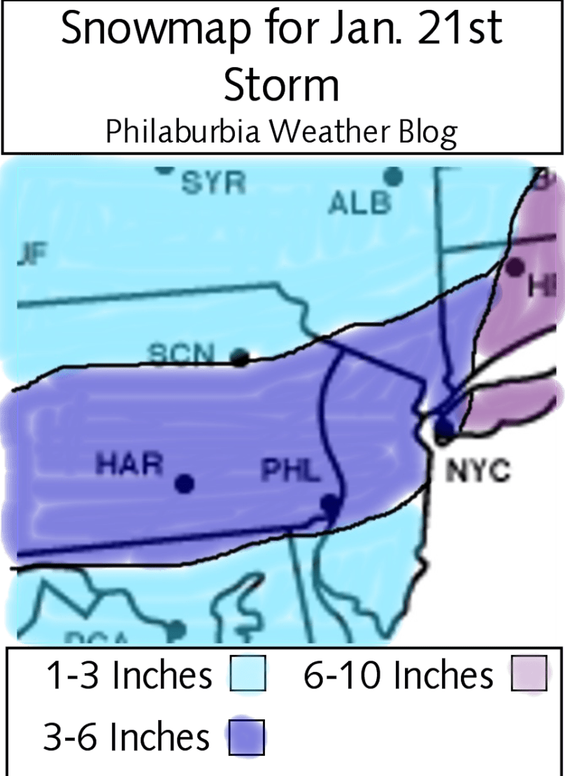
Hi everyone. I have finally come to a conclusion for the storm on Friday. Most models are agreeing with each other at this point and are generally showing a 3-6 inch solution for the area. Now, many of the news stations (aka my enemies) will be calling this storm with lower totals compared to what I’m predicting. I have put into account the super high snow ratios that are occurring in the Midwest right now (30:1) and make a logical prediction that these high snow ratios will continue as the storm passes to the south of us. A normal snow ratio is 10:1, meaning that 1 inch of rain will get 10 inches of snow. Because most models use liquid equivalent precipitation predictions, it is up to the weather geeks and meteorologists to decide what the snow ratio will be. If we do get 20:1 or 30:1 ratios (meaning 20 or 30 inches of snow per inch of rain) we will easily get 3-6 inches of fluffy snow.

So on to my official prediction: 3-6 inches of fluffy high ratio snow. Totals will be higher up to the northeast and lower to the southeast.

Time frame: Starting at around 1 AM Friday morning, ending in the late morning. Heaviest snow will fall during the 4-7 AM range.

Schools: Delays will be the most likely outcome. Closings, in my opinion, are really becoming less likely right now. I wouldn’t be surprised if a few schools do close, but most will have a delay if everything goes as planned (which it never does…).

Snow Map: Here’s the snow map. Pretty explanatory and simple compared to previous storms

Snowmap for Jan 21st Storm

Looking forward: Next Tuesday into Wednesday I will watch as a snow/rain/mix event is becoming more and more likely. February 1st and 2nd of the week after could see a storm as well.

The Pattern Continues: Another Storm Friday


It’s been a very busy time for many meteorologists and weather enthusiasts. The pattern we are in right now just keeps sending storms across the country and off the coast. Another coastal storm is expected to arrive on Friday early morning in a similar setup that we had for the post-Christmas storm.

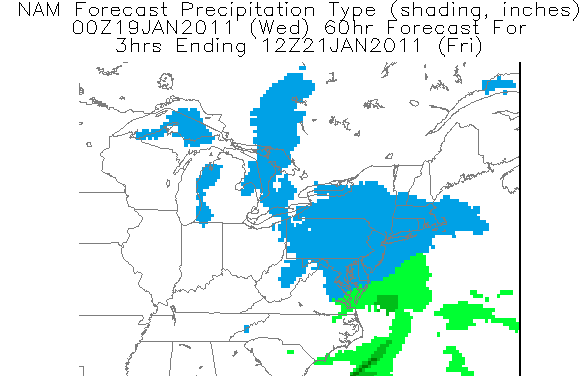
Current thinking: There are 2 scenarios (huge surprise there) for this upcoming storm. The European and GFS computer models want to weaken the phasing of the storm and wrap it up near Atlantic Canada. The NAM and a few other models have generally shown an earlier and stronger phase which would bring a significant snowstorm to the area Friday. If the storm follows the GFS scenario, we would get a general 3-6 snowstorm. If the NAM solution is right, a general 8-12 inches would fall Friday morning. One positive aspect of this storm regardless of what scenario comes true is that we’re definitely getting some snow. Friday morning commute will be pretty bad even with the 3-6 inch scenario.

1/21 NAM solution

Schools (To make my classmates happy): For the 3-6 inch scenario, a delayed opening is likely as the snow will fall smack in the middle of the morning commute. If the 8-12 inch scenario is right, then there would be widespread closings.

I am confident we’re getting at least 3 inches Friday morning. What I’m not fully sure of is the storm track and the specific snow totals.

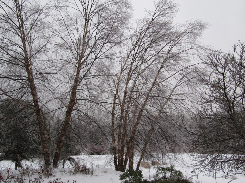
And finally I want to thank my mom for taking these pictures of the ice on the trees this morning after I left for school. This was before temperatures rose above freezing earlier today.

Ice on Birch Trees

Ice on Bush

More updates to come on the Friday storm including a snow map tomorrow night most likely

Detail on the Wintry Mix Storm Tomorrow Morning


Update 5:30 PM: So far no real changes on the models. Now-casting will probably be the best way to predict from this time forward as the storm starts to wind up along the coast.


Hello everyone. I won’t be doing a snow map for this storm, just because of its complexity in nature. The Philadelphia area is looking at a very sloppy storm Tuesday morning as a low pressure system rides the trough to our east. The storm won’t bring in the cold air like the storm last week, therefore giving us a wintry mix. By midnight tonight, snow should start to fall across the area and accumulate a general 1-2 inches. By early morning, the snow will turn to freezing rain as warm air aloft takes over. Freezing rain is pretty much ice. It looks like rain is falling, but because the surface temperature will be lower than 32 degrees, when the rain hits the surface, it will freeze over.

The freezing rain will turn to rain by 4-5 AM south of Philadelphia and 8-10 AM north of Philadelphia. I still am not too confident in the time frame of this storm. Wintry mix storms are generally the hardest to predict, as you have to rely on where 32 degree mark will be at the surface and in the upper atmosphere. There is a chance that this storm busts and a chance that this storm turns into a major ice storm. I would say a major ice storm is unlikely at this point, as most computer models are in agreement Temperature wise.

Schools: It will be a difficult decision for schools in Bucks, Montgomery, Mercer, and Hunterdon counties as the freezing rain will be falling during the morning commute. A delayed opening is pretty likely at this point for most schools.

Next storm: A SNOWstorm could hit the area on Friday. More on this once the slop storm is over.