Some Snow this Weekend, Then Seasonable Weather Next Week


The active weather pattern continues. The post-christmas storm proved to be a large rain and wind maker for our area. Snow reached a foot over much of Northern New York and Western Pennsylvania. There was an unexpected burst of snow at the beginning of the storm for areas north of Philadelphia, which created some slippery conditions on the roads during the afternoon hours. By the evening, the warm sector of the storm took over and temperatures rose above 32 degrees.

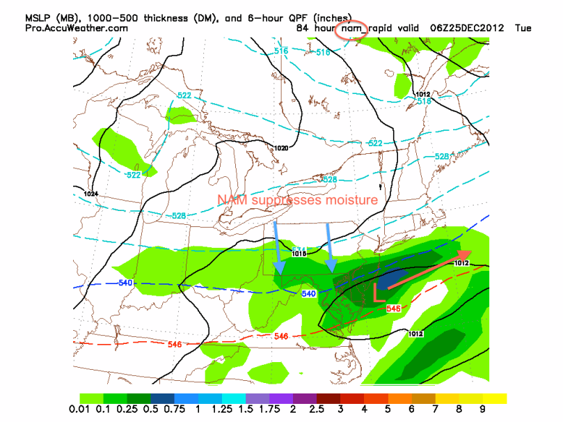
Our next storm will affect the area on Saturday. This will likely be an all snow event, with the low pressure being much weaker than the last. There are two possible tracks for this next storm. The GFS model shows a storm that hugs the coast and drops 3-5 inches of snow for much of the I-95 corridor. The NAM weather model projects the storm sliding south and out to sea. Totals would be 1-2 inches in this scenario.

Here is the GFS at 2 PM Saturday:

GFS Sat 2 PM
GFS Sat 2 PM

The NAM shows a much weaker solution, due to the distance the low pressure is from the coast:

NAM 5 PM Sat
NAM 5 PM Sat

Timing and Effects:

Snow should start falling by mid morning in most places. Snow could get heavy by 2 PM, and should start to slow down by 8 PM on Saturday. Roads should be a little dicey in the afternoon, and icing could occur at night. Keep it slow on the roads on Saturday and Saturday night.
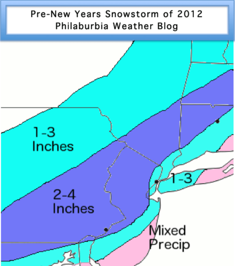
Snow Map:

I am a bit conservative on my totals for Saturday’s storm. I call for 2-4 inches for most of the Delaware Valley. In Central PA, Southern NJ, and NYC, I have 1-3 inches. By the shore, temperatures will be too warm to support snow accumulation.

Snow Map
Snow Map
Advertisement

Light Snow Today, Rain Wednesday, and Another Storm Next Weekend


As I mentioned a few days ago, a minor shortwave clipper system is passing over the region today and will drop a quick coating on places north and west of the city. Looking at the current radar, some dynamic cooling is occurring where snow is falling in Maryland, causing temperatures to fall as much as six degrees in places. By 6 PM, precipitation will start falling in the Philly area and will likely change to snow for a time. Things should start ending by midnight and skies will clear by Christmas morning.

At this point, it looks like the storm on Wednesday the 26th and Thursday the 27th will be primarily rain. Most models are in consensus and are showing a strong low cutting up the Appalachians. The storm will eventually transfer to the coast, but it will be far too late to bring in the arctic air aloft to support snow for the Delaware Valley. As a result, the precip type in this storm will primarily be rain, heavy at times. There is a chance for some snow on the backside of the storm Thursday morning, but I would not expect any accumulation.

NAM Wednesday Storm
NAM Wednesday Storm

Our active pattern will continue as another storm is possible next Saturday into Sunday. The European forecast model has been showing a coastal low bringing us some decent snow totals, while the GFS model has been showing the storm out to sea. More details will emerge for this storm as the week progresses.


Two Possible Snowstorms Next Week


Hey everyone. My first semester in college is complete and the weather pattern is starting to heat up. We are looking at a very active week weather-wise. First, a clipper system will affect the area Christmas eve into Christmas day. This storm could drop 2-4 inches of snow by Christmas morning. The second storm will hit a couple of days later. This system will be much larger than the clipper and has the potential to drop over 6 inches of snow over parts of the Northeast.

Storm 1: Christmas Eve Clipper

A weak low pressure system will form over the midwest and skirt to the south of our region on Monday night. Cold air will be first rushed in from the northwest, then transition to the northeast. As a result, precipitation will likely fall as snow. With any clipper, however, the amount of moisture associated with the storm is a concern. If there is enough moisture in the atmosphere and the storm starts to interact with it, snow will fall. The latest GFS forecast model run shows this scenario.:

GFS 2 AM Christmas Day

The NAM forecast model suppresses the moisture, which would lower any snow totals significantly.

NAM 2 AM Christmas Day

In terms of snow totals, if the GFS scenario is correct, 3-4 inches of snow will be on the ground by Christmas morning. I know many kids will be ecstatic when they see a few fresh inches of snow Christmas morning. If the NAM is correct, then a general 1-2 inches could fall.

Storm 2: The Nor’easter? December 26th-27th

Storm 2 is a much, much harder forecast. In terms of teleconnections, we are dealing with a positive NAO and a negative AO, usually not the best signs for large big city nor’easter.  Nonetheless, the forecast models have been showing a possible major storm next Thursday. There are multiple scenarios that the models are projecting for this storm.

Scenario 1: Nor’easter; Mix to snow in Philadelphia, all snow N&W of the city

This scenario is what the latest GFS run has shown. The storm digs the jet and rides the coast bringing in enough cold air to support heavy snow. The heaviest snow would occur Wednesday night into Thursday morning. From this solution, a general 8-12 inches would be expected for areas north of city. Because we are still a little less than a week out, it is very hard to determine if this is likely or not.

GFS nor'easter 8 PM Dec 26th
GFS nor’easter 8 PM Dec 26th

Scenario 2: Apps Cutter

Scenario 2 is supported by the European model. This would bring the storm up the Appalachians and push warm air into the Philadelphia region. The form of precipitation with this storm would be mostly rain, with some snow on the backside of the storm. Throughout this past week, this scenario was looking as the more likely solution, but many forecast models have started to back away. Over the next few days, the legitimacy of this scenario will be tested. By Sunday, I should have a better idea for this storm and the path it will take.

It is going to be a busy week for many forecasters across the Northeast; stay with Philaburbia for updates and snow maps for the upcoming storms.