Forecast for Sunday Feb 28th


Hello everyone, sorry for the very late post. I decided to take a day off today after the stress of the last storm. Anyway, there is another storm in our vision and is looking out to sea right now, but could shift west and give us a decent snowstorm!

Sunday: Partly to mostly cloudy depending on whether you get flurries or not Hi: 41

Sunday Night: Clearing out and colder. WATCH FOR REFREEZE. Low 29

Monday: Sunny and warm. Hi 48 Low 33

Tuesday: Sunny in the morning becoming partly cloudy by the afternoon. Hi 46 Low31

Wednesday: Snowstorm? IF not, then partly cloudy skies Hi 36 Low 29

Coming tomorrow: An analysis of the next storm and a story on the Tsunami

Advertisement

Top 10 Snow Totals and Forecast


Sunny skies are prevailing right now as temps hold around freezing. Totals ranged from a foot in the northern areas (except for Chester County, where for some reason got more than everybody…) to five inches in the southern areas. I know that this storm may have been a little overhyped, but it still caused many power outages and travel problems. Anyway, here are the top 10 snow totals:

1. East Mantmeal in Chester Co. – 12.0″ (Note that east nantmeal was the # 1 snow total for the last blizzard with 26.8″)

2. East Rockhill in Bucks Co. – 11.7″

3. Perkasie in Bucks Co. – 11.7″

4. Montgomeryville in Montgomery Co. – 11.5″

5. South Coventry in Chester Co. – 11.3″

6. Exton in Chester Co- 10.1″

7. Royersford in Montgomery Co. – 10.0″

8. Chesterbrook in Chester Co. – 10.0″

9. Tabernacle in Burlington Co. – 9.9″

10. Trappe in Chester Co. – 9.8″

And now the forecast for the next few days:

Tonight: Snow showers from snowicane will slow down as the night progresses. Wind also dying down. Low 28

Tomorrow: Occasional flurries throughout the day, but nothing to accumulate on anything. Warmer Hi 40

Tomorrow Night: Clear skies Low 30

Sunday: Mostly sunny skies with snow-melt. High 41 Low 29

Monday: Very warm. Will feel more like spring. Sunny skies Hi 47 Low 32


The Wrap Up


Well, there are sunny skies at my house right now after the storm blew through the area during the nighttime hours. Sorry I couldn’t update in the middle of the night, I was sleeping. The storm is starting to dissipate as the dry air is starting to break up the precipitation The NWS service nonetheless extended the WINTER STORM WARNING until 5:00 PM because some of the snow showers will be heavy and localized.Overall I think I did pretty well with my snow predictions for the northern areas. For the southern areas however, the storm was a bust as the low went further north as expected, therefore bringing its precipitation north.

Hopefully this will be the last storm of the season because I’m kind of getting tired of the stress before every huge blizzard that comes through the area. There is a chance of another storm Wednesday into Thursday and it is looking pretty good for 5-10 inches of snow. Right now it is pretty far out, so you never know what will happen (hopefully something light).

Top 10 Snow totals coming later and maybe pictures

Anyway here is a satillite image of the snowicane as its being called:

Late February Snowicane

Updates During the Storm


10:30 Update from Jason: STORM REALLY WRAPPING UP! 973 mb pressure at the eye of the storm. CAT 2 HURRICANE pressure! NYC is seeing extremely heavy snow and all that will mostly likely head to the area overnight. The low will stall out over North Jersey so expect a few hours of blizzard conditions (1-2″ per hour rates, 30+ mph winds) for a few hours in the morning! I am really not sure about how much snow is going to fall, but its looking pretty good according to the radar! My house is literally shaking from the winds as I am under an extremely heavy snowband right now. Expect these snowbands to keep moving through the area until tomorrow noon. Otherwise have a restful night, I know I won’t!!!

8:30 Pm Update from Jason: Winds are finally starting to howl and the snow is starting to stick on paved surfaces. The storm is about to turn westward and give us the worst of the storm overnight. Overall, the snow totals may be a little lower than I thought, but this storm is still a monster and will do  a lot of damage to the area. I am guessing most schools will be closed tomorrow, but as of now most aren’t. I will have the forecast for the coming days later tonight.

The snow is still very wet, so making snowmen will be no problem unlike the last few storms where the snow was extremely dry! Hopefully you’ll be able to make one this size:

Tallest Snowman in the World

3:30 update from Jason: Snow is definitely falling at a faster pace at my home in Bucks County. It looks like the lull of precipitation is starting to dissipate and the heavy snows starting to reform again. My snow totals may be a little off for the southern areas because of the sharp cutoff of snow so far from this storm. I still think anyone Philly northward is going to get 10 inches or more…. Blizzard conditions will occur tonight with tropical storm force winds. There will be some pictures from Brett’s house later on this afternoon. If you have any questions, just ask.

Update 12:15 Pm from Jason:

The snow is falling at a nice pace here in Princeton. Not much wind so far, but they will kick up later today, reflective of the NWS issuence of a Wind advisory. So far the snow has been very wet and hasn’t been sticking to many roads. This will change as the storm will wind itself up west and bring in the cold air from Canada. Right now the Jackpot zones in the Philaburbia Coverage area look to be Mercer and Hunterton counties as they will be the closest to the storm.

Expect a lull in the precip this afternoon in areas South, which could lower their snow totals a bit. There will be another update in a few hours with some pictures and snow totals

Brett and I will be providing updates during the storm to keep you informed of whats happening around the area. Also refer to this current radar image for reference during the Snowicane:

Continueously Updating Animated Radar

The Snow Map and Explaination


I’m so sorry for the extremely long delay on my snow map; the application I use to make it kept crashing when I saved the map, so I had to keep starting over.

The Snowicane of 2010 is going to be a monster. It will go up the coast and stall out in over Short Hills NJ for a little while. As the storm stalls, it will also bring heavy snows and winds to our area for an extended period of time. The weather models have finally cut down the errors in their runs, so I am pretty confident about this storm. Here is the timetable for it:

6:00 AM Thursday: Snow starts up in most of the area, going from south to North

1:00 PM-7:00 PM Thursday: Heavy snows and Blizzard conditions plague the area during the afternoon on Thursday. Expect blizzard conditions and maybe a BLIZZARD WARNING.

8:00 PM Thursday- 8:00 AM Friday: During this time period, the storm will stall over North Jersey and bring moderate to heavy snow throughout Thursday Night

12:00 PM Friday: Snow starts to wind down and storm weakens and starts to pull out

1:00 PM Friday- 8:00 AM Saturday: Scattered Snow Showers throughout Friday

Note that there is a WINTER STORM WARNING in effect until 12:00 Pm Friday.

AND NOW DRUM ROLL!!! MY MAP:

Snowicane Snow Map

Also, there is a storm that may hit the area next Wednesday, with some MORE snow!!! This could be the last snowstorm of the season!

A Little Explaination for the Upcoming 3rd Major Blizzard of 2010


Update at 11:30: The newest models just came out and are going with a general 12-15 inches of snow. Anything could change right now considering the model’s inconsistency. 6ABC news called this storm a hurricane with snow aka a snowicane! This storm is really blowing me away with its size and amount of precipitation that the models are projecting with it! Also I forgot to mention earlier that a WINTER STORM WATCH is issued for late Wednesday Night in to Friday. I would expect a WINTER STORM WARNING by tomorrow morning followed by a BLIZZARD WARNING during the storm!

This storm will be big. What defines big, you ask? A low pressure with winds that are going to be sustained in the 40 mph range throughout the Philaburbia Coverage Area. This storm won’t be just gigantic, it is also going to last a very long time. It is expected to start Thursday morning (8:00 AM range?) and end by late Friday night. This will most likely be a paralyzing storm for most of the region with schools closing on Thursday and Friday and businesses shutting down. There will be many, many power outages as well because of the heavy nature of the snow; great for snowmen, but terrible for tree branches and power lines. I am not confident to post a snow map yet because the last model run wasn’t as strong with this storm.

Note that this storm has a potential of being a huge bust (failure) because of the models inconsistency! This is just my opinion on what I think will happen based on the pattern of this winter.

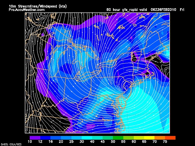
Anyway,  here is a picture of the storm I found on Accuweather.com…I found it very intriguing because this monstrous low pressure is right over Mercer county, which is right in the area!:

Low Pressure System Over Delaware River with Strong Winds

The lines represent the wind speed: the closer they are to each other, the higher the winds

Hopefully, I’ll be able to post a snow map either later tonight or tomorrow afternoon…

Forecast for Tuesday the 23rd and Beyond


Here is the forecast:

Tonight: Mix changing to freezing rain, then to just plain rain. Winter Weather Advisory out for Bucks, Montgomery, Hunterdon, and Somerset for the risk of ice.  Low 33

Tomorrow: Drizzle and occasional steady rain throughout the day. Warmer. Hi 41

Tomorrow Night: Intermittent snow and rain showers; little or no accumulation Low 32

Wednesday: Becoming mostly cloudy after the morning… nice day to take a break from the precipitation falling from the sky. Hi 43 Low 30

Thursday: Chance of snow showers after noon. Becoming steady by nighttime. Possible Blizzard at night. Hi 36 Low 27

Coming tomorrow: Will the NAM model verify its blizzard scenario for the area on Thursday night/Friday? Updates on the unsettled weather, and the forecast.

Update on the Surprise Snowfall Tonight


The surprise bursts of snow which have been moving through the area is a real nice surprise. I do think that it will turn to rain by midnight tonight, but at least we’re getting SOME snow. Accumulations should be low even though it’s really coming down. There is a winter weather advisory for Bucks, Mont, Hunterdon, and Somerset. The NWS posted this not because of the snow, but for the freezing rain which will be moving through the area tonight. We could see a 1/10″ of ice on trees and streets by morning. Tomorrow will be damp and raw, as the 1st system moves out and another one moves in

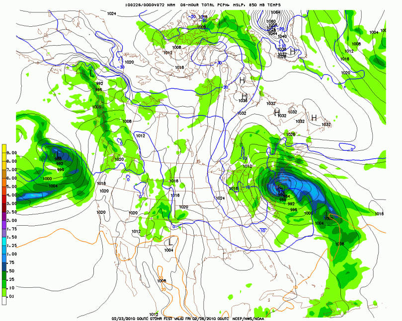
Here is a preview of the next potential storm for some snow on Thursday Night/Friday… its really looking strong (15-20 inches of snow possibly!!!!):

Crazy big storm coming our way

The Past Week in Review


Welcome to the second weekly “week in review” post from Philaburbia Weather. We will start with last Monday and go to Sunday:

Monday the 15th: Clouds prevailed on Monday with a clipper system moving in during the night. Accumulations ranged from 1-3 inches of new snow on top of the foot of snow we had already.

Tuesday the 16th: Snow lasted in the morning fairly hard in places. Didn’t really stick to the streets, so traffic was steady throughout the day. Stayed cloudy into the afternoon and eventually we saw some sun by sunset.

Wednesday the 17th: Wednesday was plagued by some hit and miss snow showers in the area. If you weren’t under any showers, you had sunny skies with a brisk wind.

Thursday the 18th: The highs reached into the 40s on Thursday with pure sunshine. There was some gradual snow-melt also occuring on this day as we started the slow process of melting the snow.

Friday the 19th: Friday was mostly sunny and a little breezy. Temperatures we comfortable though with the high reaching once again into the 40s.

Saturday the 20th: Wind and sun prevailed once again on Saturday as for the third straight day, highs made it into the 40s. By this time, the snow-pack from the past few weeks was down a few hearty inches.

Sunday the 21st: Sunday was the warmest day of the week with highs in the mid 40s. Once again pure sunlight was in control for the entire day.

Here are some temp. and precip maps from the past week:

Temperature Compared to Normal for 2/15-2/21

And the total precip map from the past week (not that exciting because we didn’t get too much precip):

Total Precipitation for 2/15-2/21

Forecast for Monday the 22nd and Beyond


Sorry guys that I haven’t updated all day, its just been really busy for me lately…I promise I’ll be back full force tomorrow afternoon with my time-line of the next RAINstorm. Yes, it turned out that my map was right on about the upcoming storm. This upcoming week has been one of the hardest to forecast of the whole winter, I have no idea what is going to happen. The only thing I DO know is that there won’t be much sun for the entire week starting Monday and we are looking at THREE storm systems in our vicinity this week! And that leads up to my forecast:

Tomorrow: Mostly cloudy throughout the day, rain arriving late Hi 41

Tomorrow Night: Rain, steady at times. Total rainfall of 1/2 inch. Low 34

Tuesday: Tuesday is in question… rain will slow down; drizzle throughout the day. Rain will pick up again at night from the second storm (maybe a mix in the northern coverage area) Hi 40 Low 32

Wednesday: Rain will slow up and maybe end as snow (that is a big maybe!!). Another lull of precipitation throughout the day with the third system arriving at night with rain (or mix) (or snow)! Very much in question. Hi 38 Low 32

What’s coming tomorrow you ask? The week past in review, the temp and precip compared to average of last week, and more on these very puzzling storm systems approaching our area!