Following a very short January thaw, winter is returning this week with both ample cold air and a storm.
Clipper/Coastal Forecast
An Alberta clipper is moving down through the great lakes region and will phase with a piece of energy off of the Atlantic coast late Tuesday night. As the clipper moves eastward, it will bring a period of snow tomorrow evening into Wednesday morning for much of the region. Depending on the timing of the coastal phase, areas north and west of Philadelphia could receive substantial snowfall from this system. The map below shows the radar tomorrow at 7 PM. According to this model (the NAM hi-res), as the clipper begins to phase with the coastal low, a broad swath of snow enhances over Central and Eastern Pennsylvania:
Clipper Phasing with Coastal
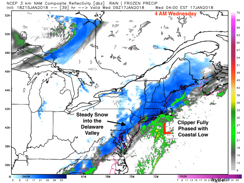
By early Wednesday morning, the phase is complete, with a full coastal storm strengthening off of New England. At this point, a wide area of heavy snow will form over New England and will extend down to Virginia:
Clipper Phased with Coastal
As with many atmospheric phases, forecasting storms like this can be difficult. A slightly earlier or later phase would significantly alter the forecast for the I-95 corridor. Based on what I’ve observed from the forecast models, 5-8 inches will likely accumulate from the Poconos into New England. Most of the major cities, Philadelphia included, should receive 2-4 inches of light, fluffy snow.
Snow will likely begin after the evening rush on Tuesday in the Delaware Valley. In areas north or west of Allentown, I would advise preparing for a significant snowstorm tomorrow into Wednesday. Wednesday morning’s commute will likely be slick as the storm begins to move out.
The storm appears to be taking a more western path, which means the heaviest of snow will push into the I-95 corridor late tonight into tomorrow afternoon. Storm totals will range from 4 inches NW of 95, 8 inches from Philly to NYC, and possibly over a foot near the coast. As with most nor’easters, there will be areas with locally higher snow amounts. The map below illustrates forecasted snow totals. Note that ratios will be higher than 10:1 in this storm, so a 10:1 snowfall map showing 5 inches will more likely be 6-7 inches with this storm:
NAM Snow Prediction
Another concern with this storm is the wind. Wind speeds will approach 30 mph tomorrow morning as the storm bombs off the coast. There is a potential for scattered power outages from fallen tree branches.
Stay safe everyone and enjoy the snow!
Original Post
Happy New Year everyone! Hope your holidays were both relaxing and fulfilling.
In the weather…
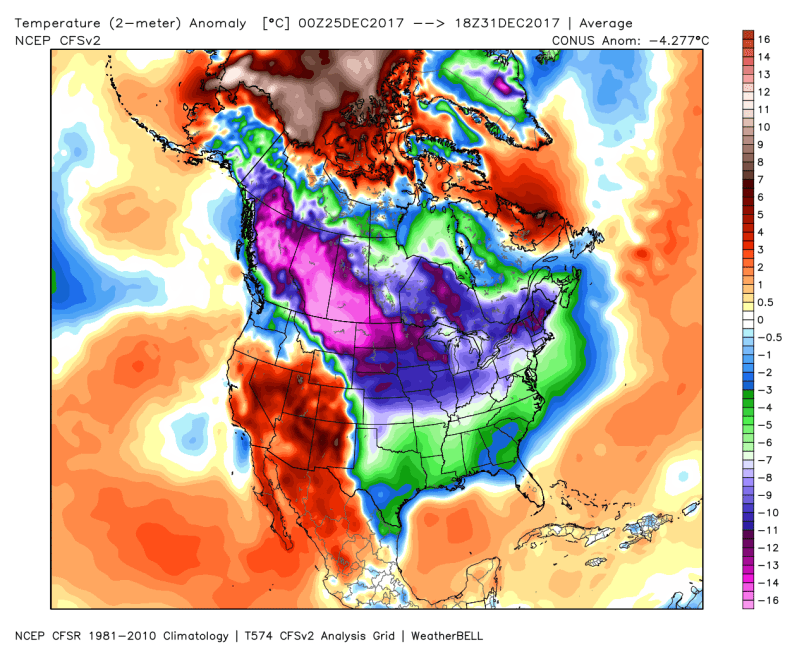
We are currently in the middle of what will likely be the coldest late December/early January period in recent memory. The map below shows the temperature anomalies from last week. Apart from the west, the nation was at least 6 degrees below normal with northern areas exceeding 10 degrees below normal.
US surface temperature anomalies Dec 25-31
The cold isn’t going away anytime soon. After the nor’easter moves through on Thursday, a high-pressure system will settle to the northwest this weekend, bringing even colder temperatures. Based on forecasted anomalies, we could see low temperatures well below 0 in New England and close to 0 from Philadelphia to NYC.
Temperature anomalies late Saturday night
Following the arctic blast this weekend, temperatures will likely return to normal or slightly above normal. However, more cold blasts are ahead, so stay warm over the next couple weeks!
Upcoming Nor’easter
The upcoming storm has all the features of a classic nor’easter. The actual system has actually already started to spin up in the Gulf of Mexico and will strengthen off the Atlantic coast tomorrow afternoon. Once the storm gathers strength, it will begin to move northeast and continue to strengthen.
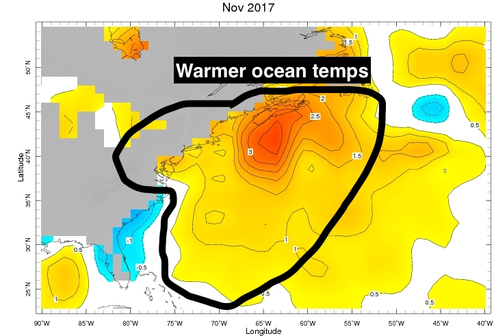
There are a few factors that favor the development of a significant nor’easter. First, ocean temperatures in the Atlantic are above normal for this time of year. This promotes faster and stronger development. Below is a map showing the Atlantic warmth:
Above Average Ocean Temperatures
Second, the current state of the teleconnections indicates conditions for storm development. The NAO will be transitioning to negative during the storm, the PNA remains strongly positive (trough in the east), and the EPO is negative. Finally, there is plenty of cold air feeding into the storm, creating blizzard conditions in some regions.
We know a storm is coming, but where and when? Right now, the nor’easter is projected to track up the coast late Wednesday and strengthen rapidly as it moves north on Thursday. The latest forecast models show the worst of the storm impacting New England with most of the heavy snow occurring east of the NJ coastline.
Thursday Morning Storm Track
By Thursday evening, storm’s low pressure will be the equivalent of a category 3 hurricane. Blizzard conditions will be occurring in much of New England while the light snow ends in the Delaware Valley:
Nor’easter Peak Strength
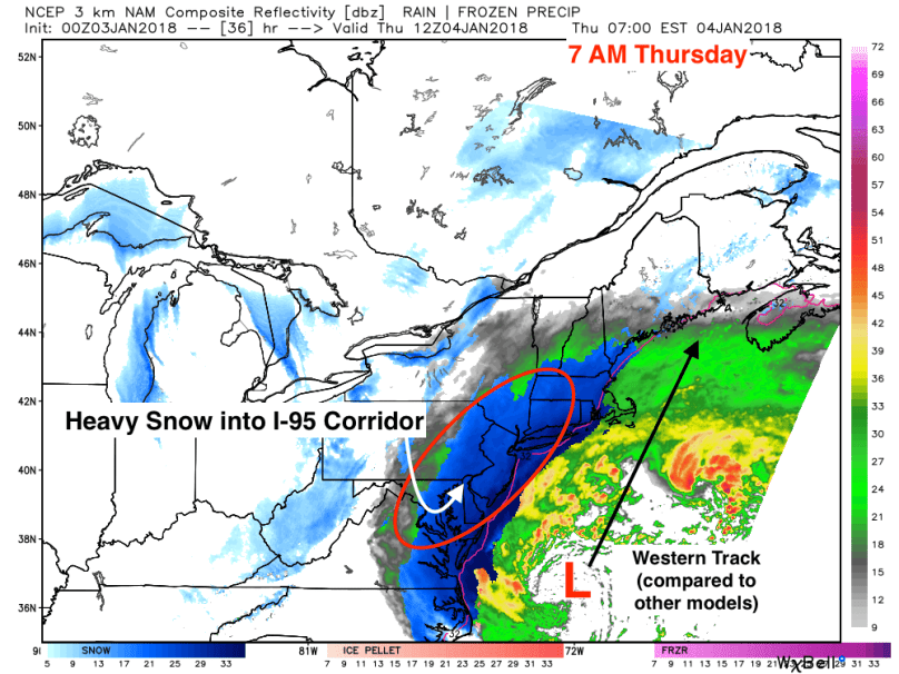
With all this being said, recent short term models have been trending slightly west. The ramifications for more westerly track could be significant in our region. As shown on the 3K NAM, a model that specializes in short range forecasting, a track even 75-100 miles west could bring heavy snows into the I-95 corridor:
3K NAM 7 AM Thursday
It is apparent there is still uncertainty associated with this nor’easter. We are currently 36 hours before the beginning of the event, which means the next 12-18 hours are critical in determining the actual track of the storm.
Based on recent data, it would be reasonable to expect a disruptive storm on Thursday. If the storm takes a more easterly track, 1-4 inches of snow should fall from this storm with more near the coast and less NW. If the storm takes a western path as shown in the 3k NAM above, 6-10 inches of snow would not be unreasonable.
If there are any changes overnight, I will post a quick update with a revised forecast tomorrow morning.