Continued Warmth this Week; Cooldown Possible for Early April


Wow, what a stretch of nice weather we have been having! As I sit here on my patio with an iced tea and a computer on my lap, I cannot seem to remember such a stretch of nice weather in March. Temperatures have been in the 70s and 60s consistently for the past 2-3 weeks and will continue for another 1-2 as a May-like airmass dominates most of the country. The pattern has really slowed down and systems are riding the jet way north. Our next chance of any precipitation will be next Saturday. Until then, enjoy the weather!

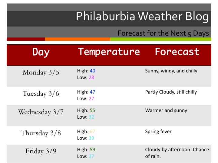
5 Day Forecast

Long Range Insight:

So, what else is there to say? Monday will be beautiful, so will Tuesday, Wednesday, Thursday, Friday, and even next Saturday morning. Amazing. Of course, things can’t stay like this forever. Like any weather geek, I have been looking for signs when this pattern will change. It seems, according to the long-range models, that early April will have a fairly significant cooldown. I could definitely see high temperatures in the 40s and lows in the 20s for a few days in April as the arctic air tries to make one last push South.


Advertisement

Very Warm for the Rest of the Week; 60s Next Week as Well


Welcome to May… in March. Temperatures are soaring into the 70s today and will reach the mid 70s by tomorrow. Next week will be warm as well, with a few more precipitation chances. Tonight, a small warm front will push through the area, while a Bermuda high will setup behind it. There will be a few showers tonight, with a chance of some rain in the morning tomorrow as well. Things should clear out before Tuesday afternoon.

Forecast

The rest of the workweek looks nice before a weak disturbance sweeps past the area on Friday/Saturday. Temperatures will stay warm next weekend into next week. Our jet stream is starting to move north and soon enough, our severe weather season will start.

About our winter:

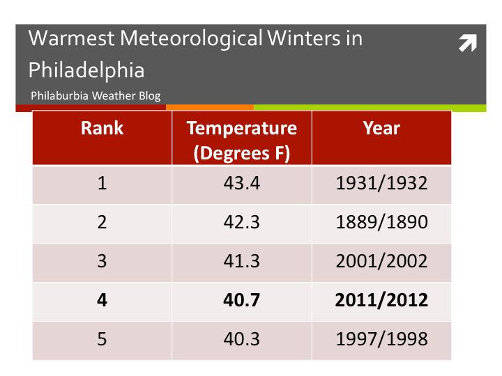
The Meteorological winter ended March 1st, and the National Weather Service official announced that this winter was the 4th warmest winter on record. My explanation for this is the prominent La Niña, as well as a very positive NAO (no blocking).

Warmest Winters on Record


Cold Start to Week; 70s by Thursday? Warm into Late March


Meteorological winter has ended, as well as ours. Spring is into full swing this week.

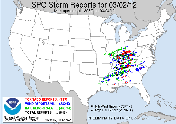
The first issue I want to comment on is the tornado outbreak on March 2nd.  Over 30 deaths were reported from these superstorms. The amount of rotation recorded in these cells was astounding, and tornadoes were coming down left and right. 117 tornadoes were reported. More outbreaks are likely in March and April, as our pattern slowly shifts to a summer one.

Our weather:

A clipper will pass to our south on Tuesday, giving Virginia a few more inches. Then high pressure will set up to our East and will warm temperatures up significantly on Thursday and Friday. I would not rule out 70 degrees in some areas on Thursday. By next weekend, a cold front will cool us down, before another ridge moves in and sends temperatures back into the 60s.

Forecast 3/4

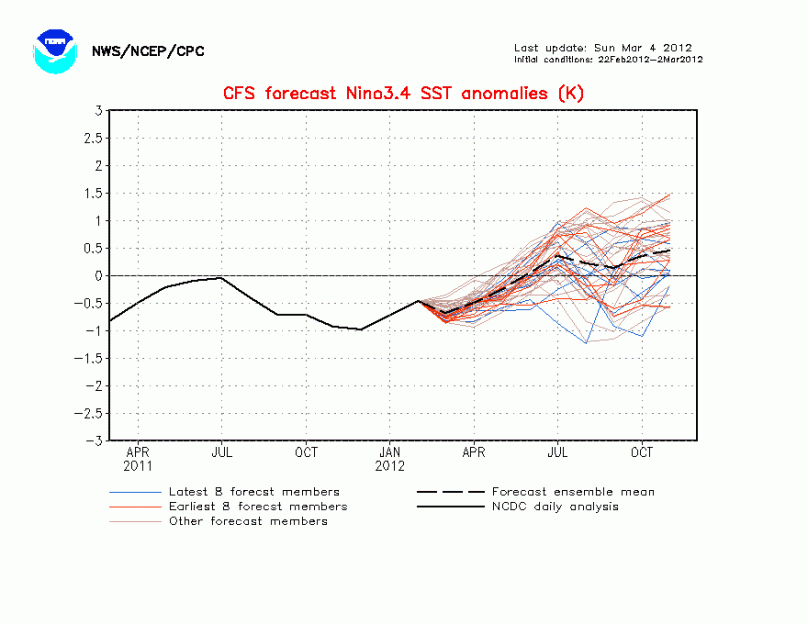
Lastly, I wanted to talk about the upcoming El Niño for the summer. Right now it is looking like we will have a weak El Niño or neutral El Niño/La Niña. This uncertainty will be extremely important for any hurricane season predictions. Let me explain:

Weak El Niño years have fairly calm hurricane seasons. 2009 was a great example of a weak El Niño. Only 10 named storms formed that year. Other El Niño years include 1997 (7 named storms), 2002 (12 named storms), and 2006 (20 named storms). If a weak El Niño exists this summer, we will likely see around 10-12 named storms with 1-2 of them affecting the mainland USA.

Neutral years, on the other hand, have extremely active hurricane seasons. If a neutral pattern exists during this hurricane season, the number of hurricanes will likely be similar to the 2001 and 2002 hurricane seasons. Those years, there were 15 and 12 named storms respectively. For each year, there was a weak La Niña transitioning to neutral, just like this year.

Many Meteorologists will be watching to see what the La Niña does as we head into summer. In my opinion, 12-14 storms is the good preliminary number based of off the La Niña 3.4 SST anomaly graph (negative #s are La Niña, positives are El Niño):