Our Astonishing Winter Continues; Preliminary Preview of the Early March Snowstorm of 2014


Hey everyone.

“There can’t be! There’s no way. There won’t be!” Those are only some of the phrases I have heard this week after telling people about the upcoming major storm on its way.  Today, I will cover some of the general details of this storm. Tomorrow’s post will cover more of the details including timing and my snow-map.

A low pressure system that is currently drenching California with much-needed rain (severe storms in LA) will move across the country and gather a substantial amount of moisture tomorrow and Sunday. The storm will become elongated as it partially phases with another piece of energy before this snake of precipitation moves through the region. The timeframe for this storm will be from Late Sunday night to early Tuesday morning.

GFS model 1 PM Monday

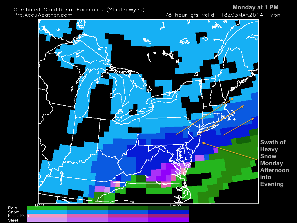
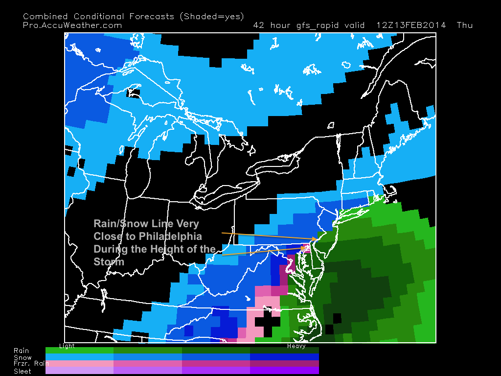
This will be a very long and drawn out storm. A round of heavy precipitation will start on early Monday morning and won’t end until the nearly the same time the next day. While there has been some model inconsistencies regarding the exact path of this storm, there looks to be enough cold air in the upper atmosphere to support snow for most of the storm. South Jersey and Philadelphia could mix a little bit during the storm it it comes further north, but this shouldn’t be enough to alter snow totals significantly.

More details will be discussed in tomorrow’s post.  Overall, this will likely be very significant storm with totals exceeding 6 inches in most places in the Delaware Valley. Welcome to March. 

Until then…..

Advertisement

Final Forecast and Snow-Map for Mid-February Snowstorm of 2014


A very large nor’easter (surprisingly, our first nor’easter of the winter) will affect the Northeastern United States late tonight into tomorrow. Even though the forecast models are still not completely in consensus about the location of the rain/snow line, I am confident enough to make an official forecast for this upcoming system.

Part 1: The Forecast

My forecast is based on a combination of the European and NAM model solutions. The NAM tends to really amplify the precipitation tomorrow morning, while the European has a more realistic precipitation field. The problem that many forecasters are faced with right now is whether a changeover to mix/rain will occur sometime tomorrow. While I believe that sleet could fall for a time around Philadelphia and its immediate suburbs tomorrow, I do not think it will last long. If the snow continues to fall heavily tomorrow morning, dynamic cooling will occur and keep the precipitation type all snow. If a lull in intensity occurs, a changeover could occur as warm air from the ocean comes in aloft. Either scenario, I believe that this will be a significant snowstorm with drastic effects on people’s lives tomorrow and Friday.

Part 2: The Map

My snow-map below shows the most snow falling north of the immediate Philadelphia area and into Northern NJ and Maryland. It is in these areas where the precipitation will likely stay as all snow and be very intense for most of the morning tomorrow. I am calling a general 11-15 inches for this area. For people living along I-95, a general 7-11 inches is expected with the snow changing to sleet, then back to snow by tomorrow midday. In south jersey and along the coast, totals will really be held down by mixing and rain.

Forecast for Mid-February Storm of 2014

Part 3: Timing and Intensity

This storm will not be a short one. A full 24 hours of precipitation will fall from early Thursday morning to early Friday morning.

1 AM Thursday-4 AM: Light snow starts from South to North

4 AM- 2PM: Peak of snow, could change to sleet in southern part of the region

2 PM-5 PM: Possible lull in precipitation (changeover likely to sleet over I-95)

5 PM-11 PM: 2nd round of moderate snow for most of the region

11 PM-3 AM: Friday: Ending South to North

Morning and evening rush hour on Thursday will be treacherous. Morning rush hour on Friday will also be extremely slick. The winds will also be high during this storm, which means for possible power outages during the height of the storm on Thursday. If you really have to drive tomorrow or Friday morning, make sure to take it slow. Schools will be closed on Thursday and possibly Friday depending on final totals.

Luckily, we are looking at a substantial warmup next week with temperatures possibly getting into the 50s, which will help us with melting some of this snow!

Enjoy the storm!

A Preliminary Review and Uncertainty of the Upcoming Snowstorm


The active weather pattern of February 2014 continues. A large nor’easter will affect most of the East coast from Wednesday night until late Thursday night, bringing strong winds and heavy precipitation to the Eastern seaboard. The question that remains is whether the precipitation will stay as all snow, or mix during the storm.

Part 1: Difficulty of the forecast

Forecasting this storm for the Philadelphia region has been far from easy. The amount of cold air in the upper atmosphere is unremarkable, which means that the rain/snow line will be very close to the city, with areas in south Jersey likely turning to rain sometime during the day on Thursday. The storm track will be key as it runs up the coast and strengthens.

If the storm is closer to the coast,  more ocean influenced warm air will be present aloft and mixing issues will occur for areas close to the city. A storm closer to the coast also means more precipitation, which could offset the mixing issues that we would have from the storm. If the storm is further from the coast, more cold air will be present aloft, but precipitation values will be lower than they would be if the storm retrograded near the coast. Conclusively, it seems like each path has its pros and cons concerning precipitation type and amount. In the image below, the blue dotted line shows the projected rain/snow line. Note this is only a projected value.

NAM Storm Location
NAM Storm Location

Lastly, many models have trouble projecting exact upper air patterns when a storm of this magnitude runs up the coast. Many times, storms this strong produce their own cold air, and many places expecting mixing issues stay below freezing.

Part 2: My Preliminary Forecast and Timing

My belief at this point is that this storm will be strong enough to keep areas around the Philadelphia region and just south all snow, which would maximize snow totals. I do believe that south Jersey and any areas close to the ocean will mix at some point during the storm. This will hold down totals in these areas. 

There is a catch, however. Many models have been showing a more westerly track recently, and I still am not ready to release a snow map to the public. Even 24 hours before the storm, there is still lots of uncertainty on the track and how much mixing will occur along I-95.

GFS Track more West
GFS Track more West


What is certain is the timing of this storm. The snow should start early Thursday morning and peak during the morning on Thursday. Things should start to slow down by Thursday evening, with precipitation ending by 10 PM on Thursday for most areas.

The effects of this storm will be great with or without mixing. Most schools will be closed on Thursday. Roads will be dangerous and I recommend to stay home regardless of the precipitation type.

I will be updating tomorrow with an official snowmap and my final forecast. Stay Tuned.


Small Clipper Tomorrow, Valentine’s Day Storm Preview; Continuing Cold


As I alluded to a couple posts ago, this February would be much stormier than previous months. Our pattern has continued to be cold however, and it does not look like any relief is in sight until at least late-February. It has been quite the last 6 weeks since the “Polar Vortex” took control over Canada post-New Years! The map below shows the astonishing number of minimum-maximum temperatures as well as record low temperatures over the Eastern part of the country (3725 reports):

Records Broken Since Jan 8th

The stormy pattern is actually good for breaking the brutal cold. We are starting to finally transition to a spring pattern, as the jet stream is becoming more active compared to earlier this winter.

Short Term: Nuisance Clipper Tomorrow:

The “bigger, badder” storm that I was talking about earlier this week will be a nuisance clipper system that will move through the region tomorrow. What prevented this storm from taking shape? The southern and northern jets did not phase, which would have created a very large nor’easter. Instead we have a small system that will drop 2-3 inches of snow around the region tomorrow.

Clipper System Light Snow

Long Range Forecast: Valentine’s Day Storm

I have been tracking this storm for the past week or so. It does look like something will materialize from this threat, but its effects on the region are still up in the air. Where the models are differing the timing of the phase between the secondary and primary low pressures. The two maps below are from the GFS (bottom image) and European (top image) models . The GFS shows a phase, but takes out all cold air aloft and at the surface to give our area mostly rain. The European doesn’t phase the two systems at all, and is a much weaker solution. It does bring in cold air, which means that the precipitation would be snow.

These differences make forecasting events like this very difficult. The Teleconnections (NAO, PNA, AO) have not been significant whatsoever (mostly neutral or around neutral), and we are in a neutral ENSO (El Nino, La Nina) phase right now. These factors make forecasting snowstorms even more onerous. Hopefully, my confidence levels will rise into the beginning of the work week, when we can actually observe the locations of the two low pressures.

EURO for V-Day Storm
GFS V-Day Storm

The timing of this storm looks to be either on Thursday or Friday, depending on the timing of the phase. I will post an update later next week with more details and whether another snowstorm is on its way.

Complex System Coming Tonight into Tomorrow; Bigger, Badder Storm on Sunday/Monday Possible


Hey everyone. 

We are currently facing a potentially nasty ice storm tonight into tomorrow. A fairly large low pressure will move northeast before transferring to the coast. Because the transfer is happening late, not enough cold air aloft will be available for snow. This means that snow totals will be very low in the immediate Philadelphia area, with higher totals North and West of the city. 

Image
Hi Res Model 9 AM Tomorrow

I am only expecting an inch or two at the most to fall before the freezing rain begins overnight. As many of you may or may not know, freezing rain occurs when the upper air in the atmosphere is warmer than freezing, but the temperature at the surface is below freezing. When this “rain” falls, it turns into ice on contact with any object on the ground: cars, trees, roads, and sidewalks. Uncertainty remains, however. At some point tomorrow, the temperatures will rise above freezing. But many computer models and forecasts are in disagreement when this changeover will occur. 

Image
NAM Surface Temperatures

What makes this forecast complicated is the snow that is currently on the ground. The snow could keep our temperatures below freezing at the surface, even though computer models are projecting them to be different. This is what scares me in terms of tomorrow’s forecast. What is my prediction? A major ice storm will occur from Philly northward and it may not change over until 11 AM or even later. Driving tomorrow morning will be treacherous as any untreated roads will be absolute ice slicks.

The weekend is looking very interesting as a very large storm could possibly affect the area. If the storm ends up wrapping up and turning into a nor’easter, totals could be close to 12 inches or higher on Sunday. Right now, however, there is uncertainty where exactly the storm will wrap up along the coast. More on this storm later this week. 

Stay safe out there!

Stormy February and Another Snowstorm Tomorrow!


Hi everyone. This has been quite the winter so far. February will mark the transition from a colder and drier pattern to a warmer and wetter one. The next two weeks will be extremely active with multiple threats for snowstorms. While the transition to spring has begun, we still need to get through another few weeks of snowy, stormy weather before the warmer temperatures arrive.

The next storm is expected to arrive tomorrow morning and drop a substantial amount of snow. The system is part of a shortwave coming off of a cold front that will pull through later tonight. The storm will be fast-moving and intense. Heavy snow will fall during the midday hours tomorrow and accumulate a good amount by nighttime. Most models have been projecting a general 6-8 inches with some isolated areas of 8-10. Totals will be held down in South Jersey because of mixing issues.

European Storm Total Projection

The heaviest snow will arrive around mid-morning and continue into late afternoon before ending abruptly. Because temperatures will be held near freezing, the snowflakes will likely be large, wet, and heavy. I do not recommend driving on the roads during the day on Monday.

Nam snow intensity
Nam snow intensity

Another, much stronger storm system will threaten the region with ice, rain, and snow on Wednesday. The location of the low pressure will be pivotal in determining the precipitation type for the area. Right now, it is looking more likely than not that we could see some ice accumulation followed by rain. Details will likely change over the next day or two as confidence levels rise.

In terms of the current teleconnections, the NAO (North American Oscillation) has been positive for most of the winter and looks to continue to stay positive into mid February.

Positive NAO
Positive NAO

With a positive NAO, the high pressure needed to produce very large nor’easters on the east coast is weakened or absent. For the rest of the winter, expect more quick hitting storms like the one tomorrow. My feeling is that there will likely be one last large storm near the end of the month that will put an end to this chaotic winter we’ve been having.

Until next time…