Small Disturbance on Tuesday, Warm Up Late Next Week


Hey everyone. Hope you all had a very relaxing Thanksgiving and Black Friday.

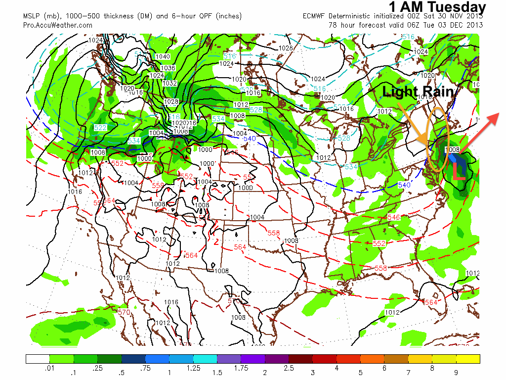
Our pattern is starting to transition toward winter. We are starting to see larger coastal storms (last Tuesday and Wednesday) affecting the Northeast and our high temperatures are starting to stabilize in the 40s. Our weather for the upcoming week is a little odd. Forecast models have been showing a weak low pressure out in the Atlantic, which has the possibility of spinning some precipitation into our area. Any precip that falls will likely be in the form of rain, as the storm will not have enough dynamics to bring in abundant cold air.

Small Disturbance
Small Disturbance

On Friday, temperatures will warm up into the upper 50s or low 60s in front of a cold front. After this front moves through, expect temperatures to drop back into the 30s with a few flurries possible next Sunday and Monday.

Long Range Analysis:

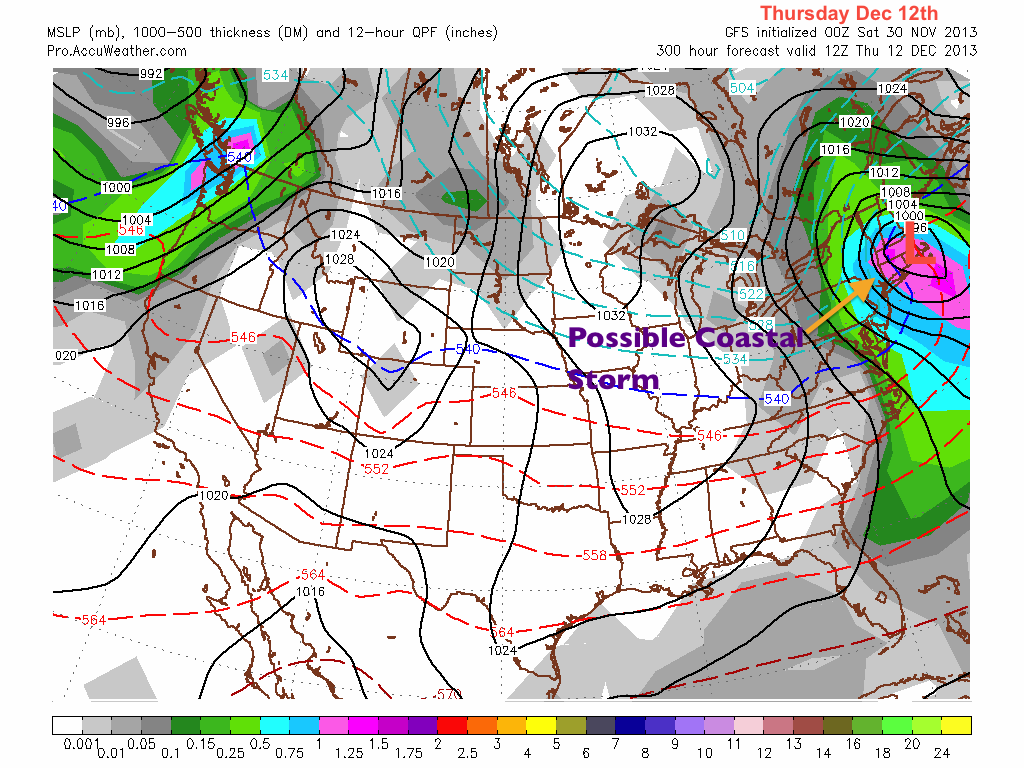
In the long-range, I am currently watching a possible coastal storm with snow implications on December 11th-14th. Many of the forecast models have been hinting at a strong low moving near or along the coast around this time frame. Right now, details are unclear including if temperatures will be low enough to support snowfall in the region. Mid-December historically tends to be the beginning of the large snowstorms in the Philadelphia area. As a result,  I will be keeping a very keen eye on this system this week and next.

Long-Range Coastal
Long-Range Coastal
Advertisement

First Snow Tomorrow Morning; Coating on Grassy Surfaces Likely


An arctic front will bring us our first snowfall of the year overnight tonight into tomorrow morning. Late last week, I was tracking a nor’ easter that could have formed along this arctic front. However, because of the positive trough and positive NAO (North Atlantic Oscillation, which affects where storms form and strengthen on the eastern seaboard) in place, this storm will form far out in the Atlantic. We will likely see many more opportunities for a nor’ easter to form along the coast as the NAO becomes negative and arctic air starts to drop down from Canada later this winter.

Positive NAO = Out to Sea

As a result of the arctic front, it will be very cold tomorrow with highs probably not getting out of the 30s. When precipitation starts later tonight, it will likely be as all rain. As the front progresses through the area, this rain will likely mix with snow then turn to all snow for a short time. Accumulations will likely be just a coating on grassy surfaces.

Projected Snow Accumulation by the North American Model
All snow 7 AM Tuesday

After the snow ends around midday tomorrow, a cold wind will prevail from the Northwest, making temperatures feel like they are in the 20s. Eventually, high pressure will set up to our East, bringing more seasonal temperatures back for the weekend. Another system looks to be in the works for next Monday. The likely precipitation type will be rain from this system. Until next time….

Continued Fall Pattern into Mid November; Winter of 2002-2003 Discussion


Hey everyone. As I sit and write this post, temperatures are plunging below freezing in many areas. Low temperatures tonight will likely dip into the 20s. As a result, tomorrow morning will be very chilly with high temperatures only reaching the mid to upper 40s!

Except for a much earlier sunset, this week will be very, very similar to last. Temperatures will rise into the upper 60s as another low pressure passes to the northeast and brings in warm air ahead of a cold front. Thursday night will likely be rainy with temperatures dropping back into the lower 50s by Friday.

Similar Pattern as Last Week

As we get to the long-range, temperatures look to stabilize in the upper 50s for the week of the 11th before another system comes in later in that week.

Long Range Discussion Series Part 2: Winter of 2002-2003

The winter of 2002-2003 will be the second analog season I will analyze for my upcoming winter forecast of 2013-2014. In terms of El Niño strength, this particular winter had a strong one, stronger than what models are showing for the upcoming winter. It can still be considered an analog winter because the summer of 2002 was neutral between El Niño and La Niña, much like the summer of 2013.

Once again, like the winter 1977-1978, temperatures were below average for the Eastern part of the country. There was a widespread negative anomaly of 2-4 degrees for this winter. Another analog winter shows below average temperatures. Unlike what I said a few posts ago about the 2013-2014 winter being warmer than average, the analogs have proven me wrong. As of right now, I am obviously starting to lean toward a colder than average winter.

2002-2003 Temp Anomalies

Precipitation anomalies were also above average for the Eastern seaboard, similar to the anomalies of 1977-1978. Countrywide, precipitation values seem to be more volatile than temperature. As you can see on the image, there is a substantial difference of precipitation between the eastern states and the midwest. What this shows me is that predicting general precipitation trends will be a difficult task. Our precipitation total will really depend on how many big storms affect us this winter, which brings us to…..

Precip anomalies 2002-2003

Probably the most memorable event from 2002-2003:  the famous Presidents Day Blizzard. This massive storm dropped over 20 inches to widespread areas between Philadelphia and Eastern West Virginia (including Baltimore). Much like the blizzard of 1978, this storm shut down major cities for days and paralyzed much of the infrastructure around these centers. This once again supports my thinking that a significant blizzard will be coming at some point this winter.

President's Day Blizzard Totals
President’s Day Blizzard Totals