Hey everyone. As I sit and write this post, temperatures are plunging below freezing in many areas. Low temperatures tonight will likely dip into the 20s. As a result, tomorrow morning will be very chilly with high temperatures only reaching the mid to upper 40s!
Except for a much earlier sunset, this week will be very, very similar to last. Temperatures will rise into the upper 60s as another low pressure passes to the northeast and brings in warm air ahead of a cold front. Thursday night will likely be rainy with temperatures dropping back into the lower 50s by Friday.
As we get to the long-range, temperatures look to stabilize in the upper 50s for the week of the 11th before another system comes in later in that week.
Long Range Discussion Series Part 2: Winter of 2002-2003
The winter of 2002-2003 will be the second analog season I will analyze for my upcoming winter forecast of 2013-2014. In terms of El Niño strength, this particular winter had a strong one, stronger than what models are showing for the upcoming winter. It can still be considered an analog winter because the summer of 2002 was neutral between El Niño and La Niña, much like the summer of 2013.
Once again, like the winter 1977-1978, temperatures were below average for the Eastern part of the country. There was a widespread negative anomaly of 2-4 degrees for this winter. Another analog winter shows below average temperatures. Unlike what I said a few posts ago about the 2013-2014 winter being warmer than average, the analogs have proven me wrong. As of right now, I am obviously starting to lean toward a colder than average winter.
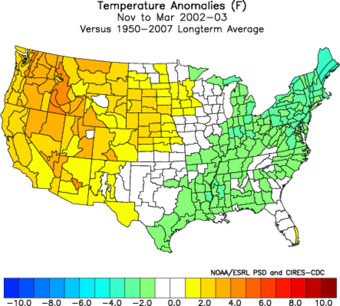
Precipitation anomalies were also above average for the Eastern seaboard, similar to the anomalies of 1977-1978. Countrywide, precipitation values seem to be more volatile than temperature. As you can see on the image, there is a substantial difference of precipitation between the eastern states and the midwest. What this shows me is that predicting general precipitation trends will be a difficult task. Our precipitation total will really depend on how many big storms affect us this winter, which brings us to…..

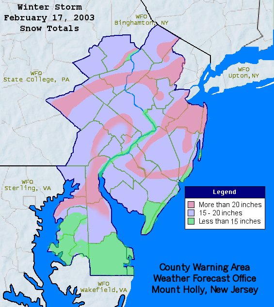
Probably the most memorable event from 2002-2003: the famous Presidents Day Blizzard. This massive storm dropped over 20 inches to widespread areas between Philadelphia and Eastern West Virginia (including Baltimore). Much like the blizzard of 1978, this storm shut down major cities for days and paralyzed much of the infrastructure around these centers. This once again supports my thinking that a significant blizzard will be coming at some point this winter.