Hi everyone. I will continue to make video forecast videos through mid-May. Let me know how I’m doing and anything you would want to see in the videos!
Thanks!
Hi everyone. I will continue to make video forecast videos through mid-May. Let me know how I’m doing and anything you would want to see in the videos!
Thanks!
I talk more about our storm this weekend. I also touch upon our continuing drought.
My first forecast video… will be doing one daily for the next 5 weeks!
Correction: Next Sunday is looking more like a clipper system, not a cold front as I stated on the video. My mistake interpreting the map.
Hi everyone. The quiet weather we’ve been having for the past month and a half will come to an end this weekend. Our drought, as well, will be coming to an end after this weekend.
There are two parts to this storm:
Part 1: Squall Line Saturday Night
A squall line associated with a cold front will barrel through the area Saturday night. Storms could be strong to severe with this line as it passes through. Here is a picture of the simulated radar of the squall Saturday night:

Part 2: The nor’easter.
After the squall line moves through, it will phase with a low pressure system moving north. A large and strong nor’easter will form and move northeast, then west into New England Sunday night. This storm will be a major rain maker, and snow could even fall in interior New England and Western PA. Around 3-4 inches of rain will fall by Monday evening. There has been some debate how strong this storm will actually get. If the cold front phases with the storm, it will be strong. If the phasing is weak, then the storm will be weaker. The amount of rain we receive will be based off of the strength and exact path of this storm.

Hey everyone, sorry for the “drought” of posts the last two weeks. It has been hectic lately for me.
So, the last few weeks have been seasonable, dry, and sunny. Our pattern since early March has been dominating the country. The Bermuda high from mid-March is gone, but the dry weather continues. A strong high has cemented itself in the midwest, but will slowly move east over the next two weeks. By next week, the high will be in the Atlantic and warmer weather (70s) will return. After that, it is looking that a few rainy days are likely into late April.
This week, look for a bit of a cooldown and a slightchance of showers. A weak low pressure disturbance will spin in the Atlantic and bring us some windy conditions, an isolated shower, and partly to mostly cloudy skies until Thursday. Highs will be in the 50s before going back to the 60s midweek.
More about the possible drought:

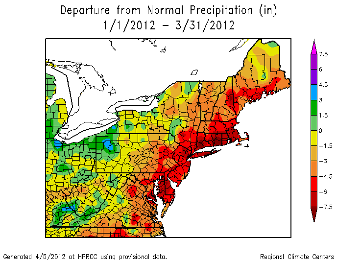
Because of the lack of precipitation over the last four months, a drought could be coming for the summer. In my opinion, I do not think this drought will last. We are headed into a weak El Niño, and historically, we have had wetter than average summers during these years. Currently, there is a major threat for wild fires. Red flag warnings will continue to be issued by the National Weather Service.
