A Little Snow Tonight, then A Mixed Bag on Friday


The next two days will not be the nicest. Tomorrow will be cloudy with an occasional snow shower or rain shower passing through the area. Accumulations will be limited to grassy surfaces.

The Friday storm has finally ironed itself out. It is looking to be a general 2-5 inch storm with rain at the onset (Thursday Night changing to snow by Friday morning. It will not be a nice day. Some roads could be pretty slick during the day on Friday so I would recommend taking it slow. A Winter Weather Advisory will probably be issued tomorrow for areas north and west of Philly.

Here is the general timeframe of the storm:

8:00 PM Thursday – Midnight Friday: Rain moves in from south to north

12:00 AM – 2:00 AM: Rain will eventually mix with snow and turn to all snow north and west of the city

2:00 AM – 8:00 AM: Snow (rain south of the city) will start to wind down and end by noon Friday

Here are some snow totals with no snow map (I have been having problems with the application I use for the map):

Bucks, Mont Co, Mercer, Chester: 2-4 inches

Philly south: 1-3 inches

Lehigh Valley: 6-8 inches

Note that these totals can easily change and areas closer to the city could receive more or less snow depending on the storm track.

Advertisement

April Fools Day Storm; Yes, it Will Involve Snow


Here is my agenda for this post: 1. Talk about storm tomorrow night 2. Talk about the big one on April Fools Day 3. 5 day forecast

1. We will be getting a coating to an inch of snow, especially north and west of the city tomorrow night as a weak low pressure system passes to the south of us. Nothing to worry about with this system because nothing should stick to the roads whatsoever.

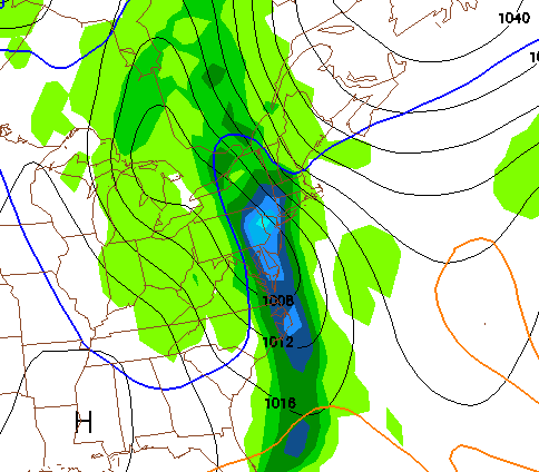
2. Now, for the Friday storm. I have been talking about this one for a while now and it has finally started to shape out the way I had thought. The GFS model has generally been on board for a fairly major snowstorm Thursday Night into Friday. Other models have been showing a more rain and snow mix, which would lower our snow totals drastically. Right now I am leaning toward the snowier solution. My early call right now is for 4-8 inches to fall Thursday Night and Friday. There will be higher totals in higher elevations. The snow will be wet and heavy; power lines and trees have the risk of falling on Friday. Because we are still 3 days away from the storm I will not post a snow map just yet. And yes, there could be school closings on Friday.

Here is a projection from the GFS of the snow. This is at 5 AM Friday and will be most likely the most intense part of the storm:

April Fools Day Storm

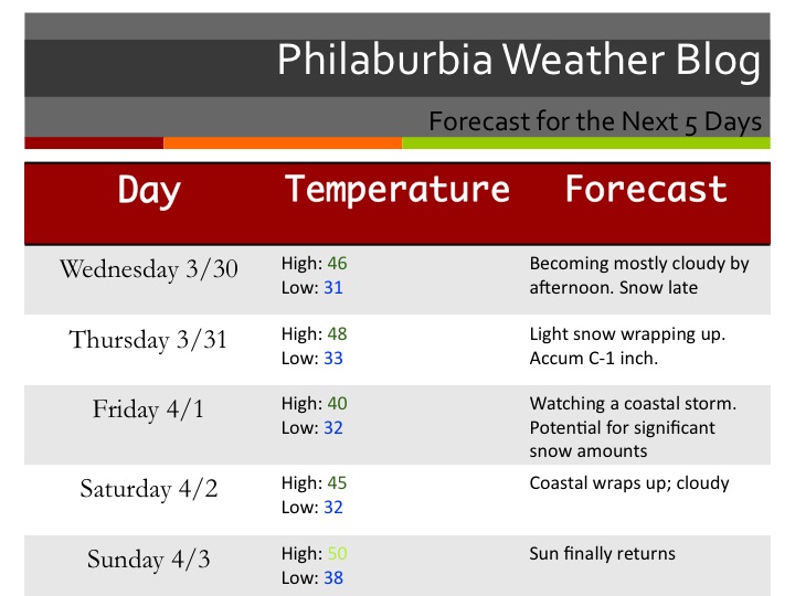
And now the 5 Day Forecast:

The Five Day Forecast

Snow map and update tomorrow!!!

New Formatted 5 Day Forecast: Two Storms Coming this Week


Hi everyone. After over a year of doing Philaburbia Weather, I finally have a presentable 5 day forecast template that I will use.

Okay, now to the weather. A very complex weather pattern is about to start with a possible 4 day period of storms. A few models are showing a storm on Wednesday. At this point, the general consensus is for this storm to ride out to sea and give us a few snow showers during the day on Wednesday. There is a chance that this storm heads further north and gives us a bit more snow than expected, but right now it is looking more like a minor event.

The second storm on Friday is the one to watch. It has the potential to really cause major traffic problems in all of the major cities. It’s going to be a close call for the precip type. As of right now, it is looking to become a Nor Easter and give some sloppy wet snow. The snow will mix with rain at some point during the storm; the question is how much rain will actually mix? The GFS model (one of the most trusted mid range models) is giving us 3-6 inches of heavy sticky snow. Another model is showing a major rainstorm with totals climbing close to 2 inches. Keep a watch on this storm on Friday, because it could cause major problems for the Philly area.

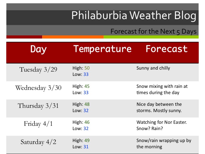
Ok and finally, my five-day forecast… in style (click to enlarge)!

5 Day Forecast 3/29

Some Snow Showers Sunday. Lots of Uncertainty This Week


Well, the “storm” that was supposed to be tomorrow will stay more south than I originally thought. Washington DC and Cincinnati will be getting a decent snowfall from this storm, not Philly. I still believe that the models are showing the storm a little too far south at this point. Many news stations are calling for just cloudy skies tomorrow, but I wouldn’t be surprised if a snow shower passes over the region and coats grassy surfaces.

For the upcoming week, the weather pattern is complicated. We are looking at two possible storms in 5 days, each with a chance to give us some snow.

The first chance would be on Wednesday. This storm is looking to be sloppy one with snow changing to rain and back to snow at the end. Right now, the models are all over the place. Some are showing it not phasing with the jet and some are showing it ride the coast and give us a decent storm. Right now it’s a waiting game until we get into the short-range.

The second chance is looking to be on Saturday. This storm has the most potential of giving us a substantial snow. The only aspect of both of these upcoming storms I am sure about are the cold temperatures. We will be having temps that will be way below normal (40 and low 50s). Bundle up this week, because it’s going to be a cold, wet, and snowy one.

Finally, here is a map showing the confusion of the weather models. This is portraying Wednesday night and shows one elongated storm instead of two separate ones. In this case, we would be getting 2-4 inches of snow Wednesday night with no storm on Saturday:


Snow chance on Wednesday


Snow Wednesday, Sunday, and Maybe (the big one) Next Tuesday


The busy times are starting up again for many meteorologists in the Northeast. Usually in late March we are dealing with temperatures in the 60s and rain storms riding up the coast. Because this winter has been one of the most extreme and surprising in almost 100 years, it is not a surprise that we will be dealing with temperatures 10-20 degrees below average for the next 3 weeks or so. I have a feeling that it will only hit 60 degrees a 2 or 3 times in the next 20 days.

The nice weather pattern we have been in for the last month is breaking; the NAO is in the tank and the PNA is rising, both signs of storminess and below average temperatures.

GFS temps compared to average for the next week:


Cold Temperatures Next Week

I also want to talk about the snow coming later tonight into tomorrow. We are generally looking at 1-4 inches of wet slushy snow. Some back-roads could be slippery tomorrow morning as well as tomorrow evening when the storm wraps up and brings the cold air back in.


We have another storm Sunday that is looking to bring a more 2-5 inch snow mostly falling during the day. Then we have another on next Tuesday and Wednesday that is looking to be big. Right now most models are showing it out to sea, but I have a feeling, based on the NAO values tanking, that the models will bring the storm west and give us a significant snowstorm.

Just be aware that we have a chance, in spring, to be snowed in once again with school closings and other snow cancellations.

Accumulating Snow Actually Could Fall on Wednesday and Thursday


Oh boy, snow. Just when people think it’s over, more of the white stuff could be on the way. This is something I’ve been watching for the past few days now, but recently there has been some model guidance that shows a decent snowfall Wednesday into Thursday. I am going to stay very cautious with this snowstorm as it is extremely rare we see any snow  in late March.

The most likely scenario is some mix of rain and snow at night on Wednesday changing to rain by Thursday. But there is a slim chance that enough cold air is brought in to change the mix to snow at Wednesday night and delay the transition to rain on Thursday. Any snow that falls Wednesday night will be heavy and wet (good for snowballs). I will continue to track this storm as it gets closer and will continue to update on its status.

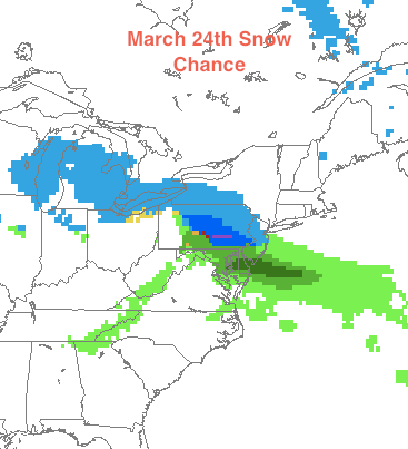
Anyway, here is the snow situation I’m looking at right now from the NAM model (2AM Thursday):


Chance of Snow on March 24th

And finally, here is the forecast:

Monday: Rain in the morning, clearing out by evening Hi: 58 Low: 43

Tuesday: Sunny Hi: 51 Low: 33

Wednesday: Becoming cloudy with some mix (snow?) at night Hi: 44 Low: 32

Thursday: Snow or rain Hi: 40 Low: 32


Regards to the Earthquake Victims in Japan


This is a special Philaburbia Weather post on the Sendai earthquake and tsunami:

Even though earthquakes and tsunamis aren’t exactly weather related, many meteorologists become interested when a natural disaster occurs. So what exactly happened in Japan yesterday? According to the USGS, the magnitude of the quake was 8.9. It occurred around 130 kilometers from the shoreline in the Pacific Ocean.  Because earthquakes are exponentially measured, higher magnitude quakes are substantially more serious than a quake maybe just a few numbers lower (7.0-8.0). Japan lies on the edge of a major tectonic plate, therefore earthquakes are part of normal life and structures are built to withstand frequent earthquakes. As a result, many of the buildings and structures on the northeastern side of the island stood without any major collapses.

Here’s a whirlpool that formed because of the tsunami:

The real damage came from the tsunami caused by the earthquake. The quake was a result of two tectonic plates slipping in a rapid fashion. Because the quake originated in the ocean, the movement of the plates caused a massive wall of water to form and start moving away from the quake in all directions. The city of Sendai received the most damage, with the storm surge rising over 20 feet. Anything in the way of the surging water was washed away and became part of the murky water. Thousands are feared to be dead and missing. There is also a scare that a major nuclear meltdown will ensue.

Here is a video of the tsunami taking over the Sendai airport:

More details will unfold as the water recedes and damage is accessed. I send my most sincere regards to the people of Japan, specifically Sendai; I can’t imagine what they’re going through right now.

That’s all for now,

adios

Forecast for March 9th and More Info on the Major Rainstorm


Anyone living close to a creek or river, I would be taking precautions for a major rainstorm expected to hit on Thursday with creek and rivers rising to flood stage by Friday Afternoon. After crossing the Delaware River at Washington Crossing this morning, I really had a chance to see how swollen the rivers have been over the last few days. With another 2-4 inches of rain coming Thursday, I could definitely see places like Yardley, New Hope, and Langhorne being flooded on Friday and Saturday.

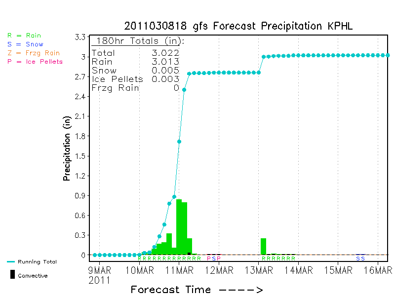
Here is a cool graphic that shows the amount of rain that Philly might get on Thursday: Click Picture to Enlarge

Precip amounts for March 10th Storm

Because someone requested it, here is the 5 day forecast:

Wednesday: Partly sunny in the morning, becoming cloudy by the afternoon High: 48 (higher temps the longer the sun is out) Low: 31

Thursday: Heavy rain throughout the day (2-4 inches of rain). Flood Watch. Hi: 54 Low: 40

Friday: Rain ending in the morning. Skies clearing rapidly by the afternoon. Hi: 50 Low: 28

Saturday: Mostly sunny skies Hi: 53 Low: 32

Sunday: Repeat of Saturday Hi: 52 Low:32

Rain Rain Go Away


Wow, after an extremely tough last week of my trimester and a sickness over the weekend, I have finally posted.

So much  has gone on over the last 2 weeks. There’s been rain, then some more rain, then a rainstorm. This is what weathermen live for (not really)! The spring is always a time of monotonous weather; temperatures are too warm for any frozen precip and they’re too cold for any severe weather. With the exception of last spring, the months from March-May generally are marked by a brief period of warmth, followed by a rainstorm, followed by a windy day.

This is exactly what is happening this week. After a pretty large rainstorm passed through on Sunday, another one will arrive on Thursday. Rainfall totals could range from 1-2 inches. Tuesday will be probably the nicest day of the week with temps in the upper 40s and calm wind. On Wednesday, clouds will take over the skies. By Thursday, temperatures will be in the mid-50s, but a steady rain will fall for most of the day. Friday will be a windy day, with temperatures around 50 but feeling like they’re 40.


Rainstorm March 10th


After this week, temperatures will rise with more rain in the forecast… welcome to spring!