Significant Nor’easter Bringing Heavy Wind, Rain, Snow, and Storm Surge to the Northeast


This one is a doozy.

A low-pressure system originating in the Southwest is moving across the country tonight and will travel east before combining with a northern stream of energy and amplifying off of the Atlantic coast tomorrow evening. The pattern has been set with strong blocking high pressures in Quebec and Ontario, literally “blocking” the storm and allowing it to intensify quickly while remaining almost stationary. The following two maps show the phase of upper atmospheric vorticities beginning early Friday morning and completing by Friday afternoon:

nam_z500_uv_vort_east_11


nam_z500_uv_vort_east_15

The meteorological effects of this setup are extreme: high winds, significant storm surge, and heavy precipitation for an extended period. To provide complete coverage of this upcoming nor’easter, the post will be split into sections beginning with track and timing, then discussing the wind, storm surge, and precipitation impacts.

Track

As I alluded to in the intro, the current atmospheric setup is prime for a massive, slow-moving coastal storm. As it moves off the coast, the storm will intensify and slowly travel northeast. The system will then slow down as it’s blocked by strong Canadian areas of high pressure to the north. This is where the forecast becomes difficult. Models are having a tough time tracking the storm and where the heaviest precipitation will fall. Precipitation type forecasting has been challenging as well, with warm surface temperatures during the onset of the storm, but dynamic cooling occurring as the storm strengthens. The maps below show the blocking, track, and strength of the nor’easter as it moves slowly eastward:

nam_pr3_slp_t850_conus2_11.png

By Friday night, we have a full-fledged nor’easter on our hands:

nam_pr3_slp_t850_conus2_17.png

Precipitation Type and Timing

Precipitation will start Thursday night initially as rain. Temperatures will be in the 50s, but will rapidly fall overnight Thursday into Friday morning. We will experience a short lull on Friday morning as the storm begins to gather strength. Round 2 will start by the afternoon as rain, then changing to snow reasonably quickly from north to south. By Friday evening, most of our region will experience accumulating snow accompanied by 50-60 mph wind gusts.

nam_ptype_slp_ne_17.png

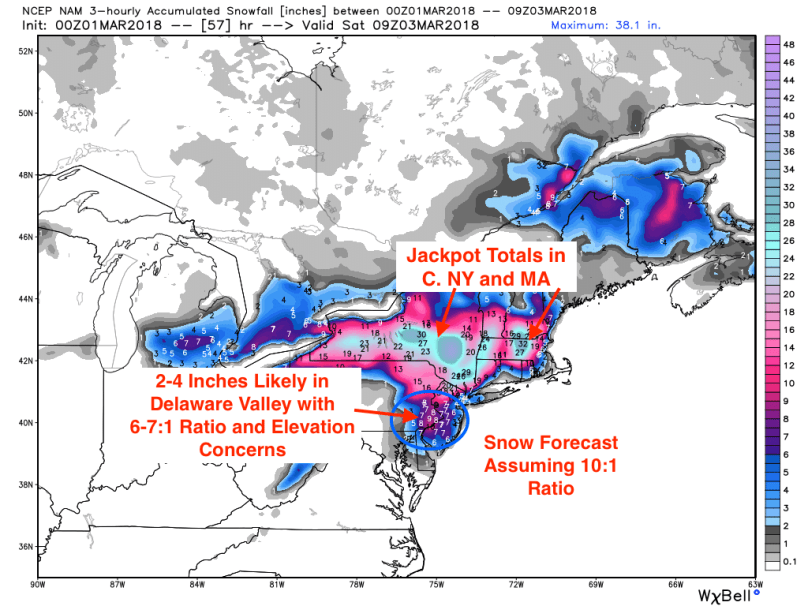
Precipitation should end early Saturday morning as the storm moves further off the coast. Based on forecast models and data, 2-4 inches of heavy snow could be on the ground by Saturday morning, with higher totals north of I-95, and lower ones closer to the coast. It is important to note that elevation could also play a key role in final snow totals, as surface temperatures could remain above freezing in areas near sea level.

nam_ptype_slp_ne_19.png

The map below shows final snow predictions from the NAM model (note that these are overstated because of a 10:1 snow/rain ratio assumption; a 6:1 ratio is more likely with this storm):

nam_3hr_snow_acc_ne_20.png

Wind

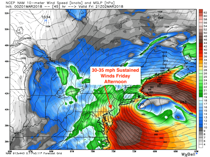
The sheer strength of this storm will create powerful wind and wind gusts on Friday. Sustained winds will reach 30-35 mph with gusts of up to 60 mph in some places. Winds will be even higher along the Jersey shore. Damage will be significant, especially with wet soil and trees weighed down by heavy snow. Expect widespread power outages by Friday night, especially in rural areas.

nam_mslp_uv10m_ne_16.png

Storm Surge

A combination of high tide and a coastal storm is never a good combination for coastal regions. Major storm surge will occur, especially in New England, with waters rising over 4 feet from normal high tide levels in Massachusetts. The NJ coastline will likely experience a storm surge of 2-3 feet, which will cause some coastal flooding during the height of the storm.

Concluding Thoughts

Regardless of the final forecast, we are looking at possibly a historically complex and prolonged event. Impacts from the storm will affect most of the Northeast, and damage from wind and storm surge will be significant. Areas in NY could receive 2-3 feet of snow, while Boston might experience a hurricane and blizzard on the same day! Philadelphia won’t be the hardest hit, but conditions will still be dangerous most of the day on Friday into Saturday. Enjoy the weather and stay safe out there, it’s going to be wild.


Advertisement

Tracking a President’s Day Weekend Snowstorm


The warm temperatures we experienced today will have a brief reprieve this weekend as a low-pressure system to our south impacts our region. A disturbance forming in the Midwest will amplify off of the mid-Atlantic coast on Saturday before moving northeast. Plenty of cold air aloft from a cold front combined with a coastal storm could bring widespread snowfall accumulation from Philadelphia to Boston.

While temperatures aloft will be cold enough to support snow, they will remain close to the freezing mark. As a result, the snow will be wet and heavy, sticking to both tree branches and power lines. Heavy precipitation will begin on Saturday night and end early Sunday morning. This is a quick mover, so a majority of the precipitation will fall within a 12-hour timeframe.

A major factor associated with this storm is the track. The further south the track, the higher chance that precipitation will fall as snow in the Delaware Valley. However, the models have been inconsistent. Shorter range models are showing colder solutions and the longer-range models are showing warmer ones. The map below is from short-range North American Model (the NAM):

nam_ptype_slp_east_18

If the NAM is correct, 4-6 inches of wet snow could accumulate along the I-95 corridor. As evidenced by the map, the rain/snow line is only 50-100 miles south of Philadelphia. Any slight shift northward of the track could have a significant impact on snow totals, especially south and east of the city.

The GFS model’s solution shows the possibility of mixing in Philadelphia and areas south:

gfs_ptype_thick_east2_11

With this solution, 1-2 inches of snow will fall with higher totals north and west of I-95.

Regardless of the precipitation type, expect a nasty Saturday night and Sunday morning, with frigid temperatures and heavy rain/snow (depending on the track of the storm).

In the longer term, a ridge in the jet stream will set up behind this system, bringing temperatures 25-30 degrees above average! A follow-up post reviewing this warmth and long-range forecast will be published this weekend.

An Active (and Warm) Pattern Ahead


Warmer Temperatures

February is opening to an active weather pattern for our region. Over the next 7 days, we will likely be impacted by three different storm systems. During this period, temperatures will be slightly above average as shown by the European anomaly map below:

Euro 7 Day Anomaly
Euro 7 Day Anomaly

As the anomaly shows, we are currently in a transition from a negative to positive PNA. What this means is that our reprieve from the cold is likely temporary.  Additionally, the Arctic Oscillation is forecast to go negative around the 10-day timeframe. This usually indicates a colder airmass entering the continental US:

AO Forecast
AO Forecast

7-Day Pattern

Until then, we have four storms to worry about! The first is arriving tonight into tomorrow. This is a system associated with a cold front moving across the Northeast. Temperatures were in the 40s today, but will rapidly drop tonight into tomorrow morning. I expect the rain to eventually change briefly over to snow overnight before moving off the NJ coast. The map below shows the high-resolution model forecast at 3 AM Friday:

NAM high-res 3 AM Friday

Tomorrow morning’s commute could be slick as wet roads freeze over once the front pulls through. Temperatures will drop during the day on Friday before plunging into the teens with wind chills into the single digits:

Temperatures Early Saturday Morning

Storm #2 will quickly follow the first, forming rapidly during the day on Sunday. This system has characteristics of a coastal, phasing with a northern piece of energy over the great lakes. Models are currently projecting a quick phase, which would push the storm further west and keep our temperatures above freezing. Super Bowl Sunday will likely be a drencher as this storm barrels through the region Sunday evening. Any celebrations following the game (knock on wood!) will be cold and wet, with temperatures around 40 degrees.

Rainstorm Super Bowl Sunday

Storm #3 is looking like a classic “Appalachian runner.” The storm will form over Missouri next Tuesday before moving Northeast along the Appalachian mountain range. This atmospheric setup will steer the storm to the west and warm up our region. Temperatures could reach the 50s on Wednesday as the storm pulls through.

Storm #3

Our pattern continues to be active following this storm, with another system impacting the region next Saturday.

Stay dry over the coming week! Go Eagles!