Another One – March Nor’easter #4


What a month this has been. We continue to experience a very active weather pattern that favors storm development off the Atlantic coast. Our fourth March nor’easter is a complicated setup that will arrive in two parts, beginning tomorrow and ending early Thursday morning. This post will separately review both stages of the storm and their impacts on our region.

March Nor’easter #4 Round One

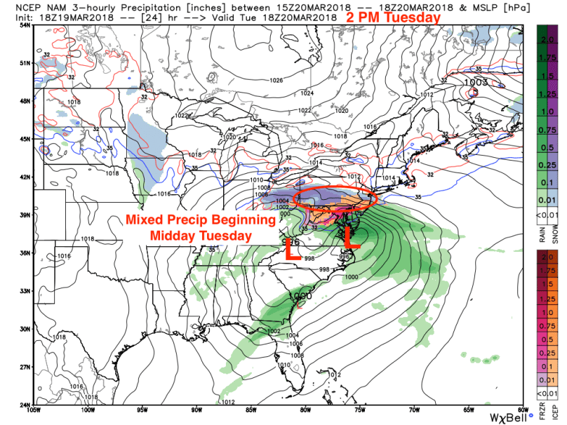
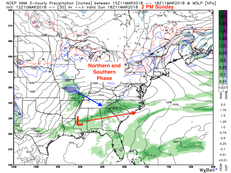
The first piece of the storm will arrive midday tomorrow with mixed precipitation in the form of snow, sleet, and rain. There will be minor accumulations on grassy surfaces, but the roads should remain mainly wet.

nam_ptype_slp_east_9.png

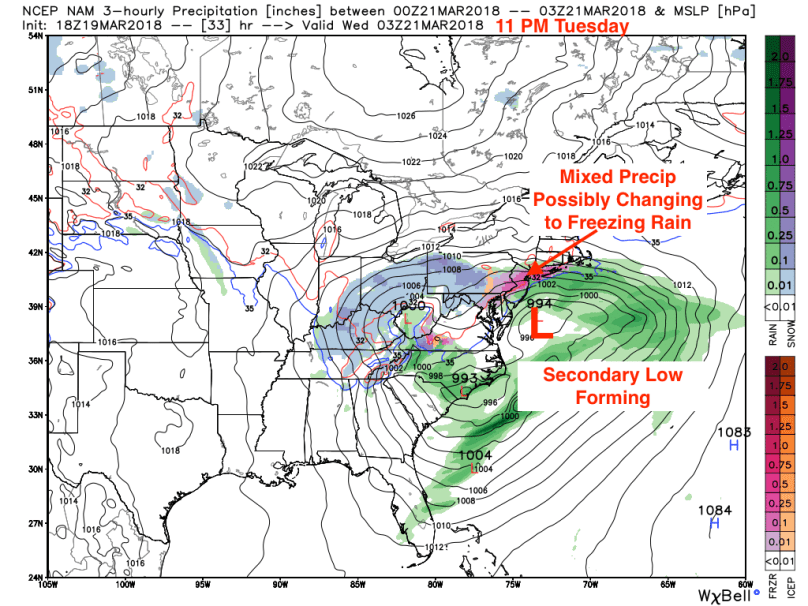
By Tuesday night, some models have indicated a prolonged period of freezing rain, which could make road conditions slippery by Wednesday morning. Regardless of precipitation type, impacts from round one will be manageable. Even with a period of freezing rain, roads will be mainly wet.

nam_ptype_slp_east_12 (1).png

Round One Timing

10 AM-12 PM: Precipitation starting as a snow/sleet mix from south to north

12 PM – 7 PM: Mixed precipitation continues, heavy at times. Minor accumulations expected on grassy surfaces

7 PM – 3 AM: Mixed sleet/rain/snow possibly changing over to freezing rain. Precipitation will slow down by 2-4 AM before transitioning to light snow.

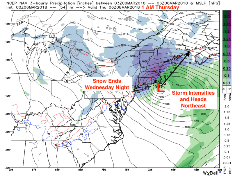
March Nor’easter #4 Round Two

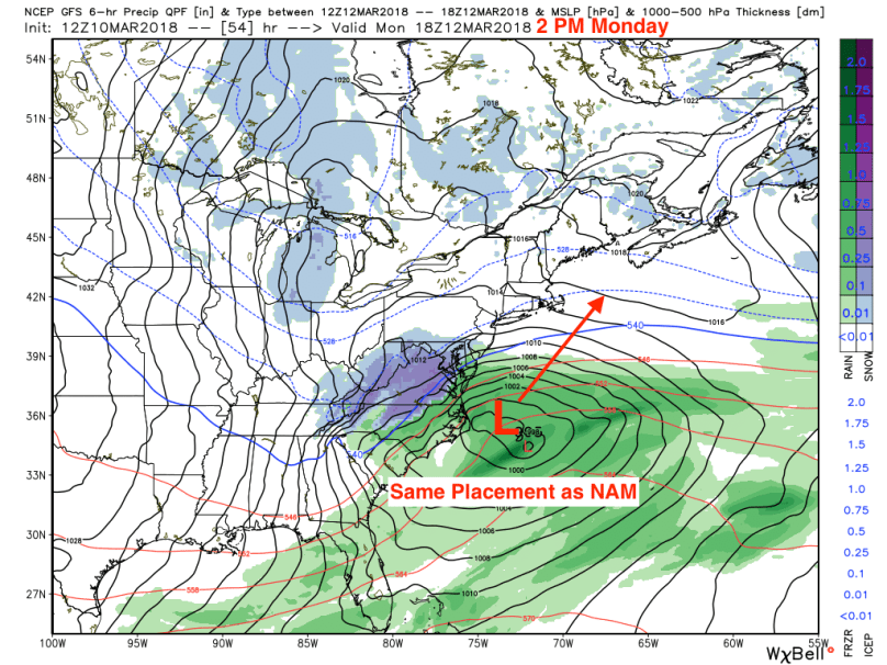
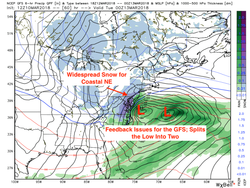
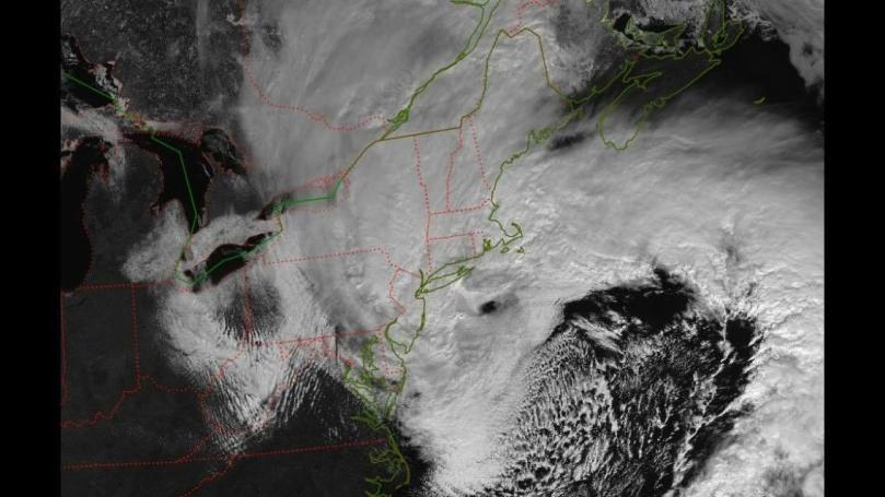
As the first system moves east, it will phase with a secondary low off the coast and begin to strengthen. The storm will begin to display the hallmark features of a nor’easter as it begins to move northeast. A resulting area of widespread snow will overtake the I-95 corridor from DC to Boston.

nam_ptype_slp_east_17.png

While a prolonged period of snowfall is expected, accumulations will be diminished because of the storm’s timing during the daytime hours. Since it’s late March, the angle of the sun is relatively high (equivalent to early October), which means any snow that falls will have issues sticking on paved surfaces. Even with these opposing factors, roads will still be very slick by Wednesday afternoon, and I would recommend against unnecessary travel after 12 PM.

Round Two Timing

7 AM – 11 AM: Light sleet/freezing rain changing to snow during the morning hours

11 AM – 5 PM: Moderate to heavy snow, plowable accumulations expected. Roads will be slush covered and slick. Widespread power outages from fallen trees and power lines.

5 PM -12 AM Thursday: Snow moving out south to north. Watch for re-freeze overnight.

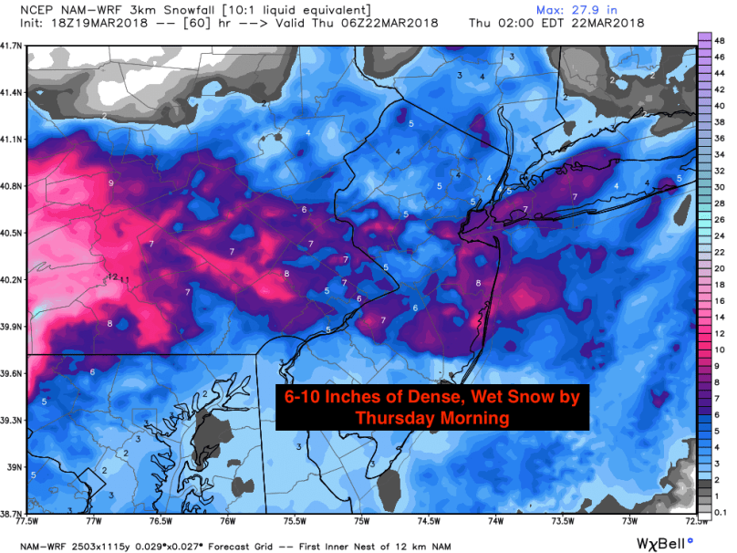
Round Two Totals and Impacts

Forecasting March snow totals are particularly challenging because of the previously mentioned high sun angle and warmer surface temperatures. Based on model guidance and knowledge of the surface conditions, a general 6-10 inches of wet, heavy snow is likely throughout the Delaware Valley. Widespread power outages are possible from trees and power lines weighed down by the dense snow. Travel will be arduous Wednesday afternoon; please take precautions if you need to drive.

hires_snow_nj_61.png

This will be a very entertaining event with all types of precipitation and significant accumulating snowfall. I will provide any updates at the top of this post. Enjoy and stay safe!


Advertisement

March Nor’easter: Round 3??


Sunday Update:

Following days of model uncertainty, a consensus solution as finally been reached. At this point, it appears that the system will phase off the NC coast and strengthen 200 miles off the coast. With this solution, New England, including Boston, could receive over a foot of snow in areas. Philadelphia will likely only see a brief period of light snow on Monday before clearing Monday night. Little to no accumulation is expected.

Original Post

A third March nor’easter could impact our area Monday or Tuesday. However, the forecasting for this storm has been impossibly hard to nail down. The models have done a poor job handling this system, and it’s leaving meteorologists struggling to find an answer to this crucial question: will there be another March snowstorm in the Northeastern US?

First off, this post will NOT be a final forecast for this storm. There is too much uncertainty at this point and delivering a premature prediction is both reckless and shortsighted. Instead, I will focus on the meteorological factors at play and what’s necessary for this storm to become a significant nor’easter.

The Track

Later today, a small disturbance will form along the jet stream in northern Texas. As this low-pressure system moves east, it will interact with moisture from the Gulf of Mexico, strengthening and bringing severe thunderstorms to the southeastern states. Simultaneously, another disturbance in the Dakotas will flow down through the Midwest, bringing snow and rain to Iowa and Missouri:

nam_ptype_slp_east_5.png

As these systems move closer together, they will begin to interact, or phase:

nam_ptype_slp_east_11.png

This is where things get complicated. The models are having trouble predicting where and when this phase will occur. The NAM and GFS models have shown an earlier phase and amplifying the storm off the Atlantic coast. The first map below shows the NAM’s solution, which is a full phase off of the North Carolina coast. Once the storm heads over the Atlantic, it will move northeast and strengthen, bringing light snows to the coastal mid-Atlantic and heavier snowfall in New England.

nam_ptype_slp_east_21.png

The second map shows the GFS’ solution, which is also a full phase off of the NC coastline. The GFS, however, is having issues figuring out where to place the low once it’s in open water:

gfs_ptype_thick_east2_10.png

The map below shows the GFS feedback issue:

gfs_ptype_thick_east2_11 (1).png

While the GFS and NAM models show a phase into a nor’easter, the European model has consistently been showing a very late and southern phase, forcing the storm out to sea. This solution is very probable, with other models such as the UK and the Canadian consenting with the Euro’s track and timing.

ecmwf_pr6_slp_T_conus2_14.png

The Situation

What I just outlined is the situation for this storm. There are three possible outcomes this storm could take:

  1. The Outlier Scenario: The northern and southern streams phase early, the storm strengthens and feeds cold air into the western side of the storm. This situation would create a significant nor’easter for the eastern seaboard with substantial snow totals from DC to Boston.
  2. GFS and NAM Scenario: The northern and southern streams phase later, but still close to the coast. The storm strengthens, but only enough to bring significant snows to New England and Atlantic Canada.
  3. The Foreign Scenario: The phase occurs very late, and the storm goes out to sea. Impacts from this scenario will be negligible apart from some high surf along the coast.

Based on what I’ve seen so far, the most likely scenario right now is #2. But, as we’ve seen before, weather is unpredictable, and things can change on a dime. That being said, please stay tuned to your local forecasts this weekend as a major nor’easter is still possible Monday or Tuesday. I will report any forecast updates at the top of this post later today or tomorrow.

Thanks, everyone!

High Impact Nor’easter: Round Two


This has been quite a pattern. Last Friday’s nor’easter had distinctive characteristics of a hurricane (see image below) with wind gusts of 60-70 mph across the Northeast. Millions of households lost power, and many remain in the dark. It could take weeks for crews to fully clear damage from fallen trees and power lines.28424504_1824455037855522_7931296027992448302_o.jpgSnow totals were significant in upstate NY, with some areas receiving over 30 inches of snow! In the Delaware Valley, totals were very isolated: Bryn Mawr received 9.5 inches of snow, but Wynnewood (4 miles away) reported only 4 inches and Philadelphia 3 inches. Boston experienced historic storm surge, and hurricane force winds were reported in Washington DC. After a historic storm like this, most people do not expect additional threats for at least a few weeks. Unfortunately, mother nature is relentless and an active pattern will provide at least two more nor’easter threats over the next week. Strap in, because it’ll be a wild ride into mid-March.

Nor’easter: Round Two

Only five days following the historic nor’easter last Friday, another coastal system will impact the Northeast with heavy snow and winds. While the meteorological setup is fairly similar to last week’s storm, there are a few differences. This system will move faster than the last one and will not produce the magnitude of wind we saw last week. There will also be more cold air in place as the nor’easter begins to strengthen. As a result, snow will be the primary precipitation type for our region (except for areas on the NJ coast). This combination of cold air and a strengthening coastal low-pressure system is a classic recipe for a major northeast US snowstorm.

Track and Timing

As with most nor’easters, the most prominent challenge for forecasters is determining the track. Currently, models are in decent agreement, with most showing a transfer of energy from a system moving east across the Ohio River Valley to a coastal disturbance off the Virginia coast. From there, the storm will begin to intensify and move northward, coming 50-100 miles from the NJ coastline:

nam_ptype_slp_ma_15.png

The storm will continue to strengthen as it moves northeast, moving out toward Maine reasonably quickly:

nam_ptype_slp_ma_19.png

From start to finish, this will be close to an 18-hour event, with the most intense precipitation falling from 7 AM Wednesday to 4 PM Wednesday. Snowfall rates will reach 1-2 inches per hour during this period, and winds will gust to 40-45 mph. The overall timing will look like this:

  • 10 PM Tuesday – 12 AM Wednesday: Light snow begins from South to North, mixing south of the Delaware River.
  • 12 AM Wednesday – 7 AM Wednesday: Light to moderate snow continues, accumulating 1-3 inches by daybreak on Wednesday.
  • 7 AM Wednesday – 4 PM Wednesday: Heavy snow moves in as storm intensifies, winds could reach 40-45 mph with visibilities near 0 at times.
  • 4 PM Wednesday – 8 PM Wednesday: Snow moves out south to north. Precipitation will end everywhere by 10 PM on Wednesday.

Final Snow Totals

This storm will bring significant snowfall accumulations to the I-95 corridor. While mixing concerns remain for areas south and east of the city, snow totals could be crippling in regions that stay all snow.

From a liquid equivalent perspective, forecast models have been showing 1.25-1.50 inches of “rainfall equivalent” falling from this storm:

nam_60hr_precip_ma_27 (1).png

Taking into account a 10:1 snow to rain ratio, this would calculate to a 12-15 inch snowfall in areas north of the city:

hires_snow_nj_55

With this particular storm, however, the snow will be heavy, wet, and therefore, less fluffy. This will bring down snow-to-rain ratios to around 7-8:1, calculating to maximum 10-13 inch accumulations. Note that maximum is bolded; banding tends to occur during storms like these, creating isolated areas of maximum snowfall with most people reverting to the mean. Taking this into account, below is my official snowfall forecast:

North and Western Suburbs (Bucks, Montco, Chester County, Central NJ): 8-12 inches with isolated totals of 14+ inches. 

Philadelphia and immediate suburbs (Delco, Mercer Co., South Jersey): 4-8 inches, with pockets of 12+

Coastal Areas: 2-4 inches (mixing will suppress totals in areas close to the coast) 

Final Thoughts

With heavy snow and strong winds, travel will be nearly impossible on Wednesday. Only drive if you absolutely have to; it’s not worth risking being stranded or hurt in a storm like this. Stay safe and enjoy the snow!

In a few days, I will likely be posting about Nor’easter Round Three, which looks like it will occur Sunday into Monday of next week.