
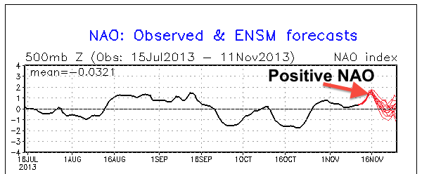
An arctic front will bring us our first snowfall of the year overnight tonight into tomorrow morning. Late last week, I was tracking a nor’ easter that could have formed along this arctic front. However, because of the positive trough and positive NAO (North Atlantic Oscillation, which affects where storms form and strengthen on the eastern seaboard) in place, this storm will form far out in the Atlantic. We will likely see many more opportunities for a nor’ easter to form along the coast as the NAO becomes negative and arctic air starts to drop down from Canada later this winter.
As a result of the arctic front, it will be very cold tomorrow with highs probably not getting out of the 30s. When precipitation starts later tonight, it will likely be as all rain. As the front progresses through the area, this rain will likely mix with snow then turn to all snow for a short time. Accumulations will likely be just a coating on grassy surfaces.


After the snow ends around midday tomorrow, a cold wind will prevail from the Northwest, making temperatures feel like they are in the 20s. Eventually, high pressure will set up to our East, bringing more seasonal temperatures back for the weekend. Another system looks to be in the works for next Monday. The likely precipitation type will be rain from this system. Until next time….
