Getting Warmer by the Weekend; Tropical Rains Next Week


Our stretch of nasty and chilly weather has finally come to an end. High pressure will set up camp southeast of the area and bring in unseasonably warm air this weekend continuing into next week. Latest model guidance has been showing a weak tropical system dropping a significant amount of rain on the Delaware Valley. The timeframe of this storm will be Wednesday or Thursday of next week. I will continue to monitor this situation.

Over the last few weeks, I have received a few inquiries about the upcoming winter. I am still waiting to see how the pattern will set up later in the month. As of right now, it looks to be a snowy winter with the La Niña (cooler Pacific temperatures) projected to shift to an El Niño (warmer Pacific temperatures). Historically, winters where this transition takes place are snowier and colder than average. I will issue an official forecast later in the month.

Here is the five day forecast:

Five Day Forecast

Lastly, this September was also the third wettest September on record. By the end of the year, we will most likely break the yearly rain record.

Advertisement

Just Drizzle for Thursday; Then Prolonged Nice Weather


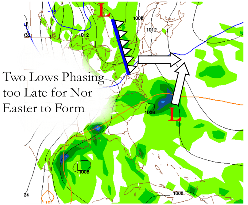
As it looks now from the latest computer models, the presumed “Nor Easter” that was expecting to arrive this coming Thursday will not be as much of a weather event as I had hoped. The two low pressure systems that were expected to phase (join together as one larger storm) before passing by our area are now looking as if they won’t join together until they pass north of the region. This would only give us cloudy skies and a few showers to accompany cool, raw temperatures.

Here is a map I made to illustrate why we won’t be dealing with a full-fledged Nor Easter this coming Thursday:


11/1/10 Storm


The rest of this week is looking to have highs in the 50s and lows in the mid to lower 30s. In the long-term, we are looking at a few storms that could give us some trouble later this weekend and into next week.

If any other details or changes arise from the upcoming storm, I will make sure to post them here. Otherwise have a nice night!

Forecast for Tuesday March 9th and Rain-Map


Hello everyone! It has been a very boring time for weather lately. There is one thing to be excited about which are the unseasonably warm temperatures lately. I am calling for temps in the 50s for most of the week. There is a rainstorm coming up Saturday with the potential for flooding, so watch out for that. Most of the main snow is already gone and we’ll probably not see the white stuff until next winter 😦 In a few weeks, I have a feeling severe weather season will finally start up!!

Tonight: Clear for most of the night. Fairly chilly Low 33

Tomorrow: Warming up nicely by the afternoon. Sunny. Hi 58

Tomorrow Night: Clear in the early evening, becoming partly cloudy overnight Low 37

Wednesday: Partly to mostly cloudy. Hi 60 (if sun stays out in afternoon) Low 43

Thursday: Mostly cloudy throughout the day Hi 54 Low 44

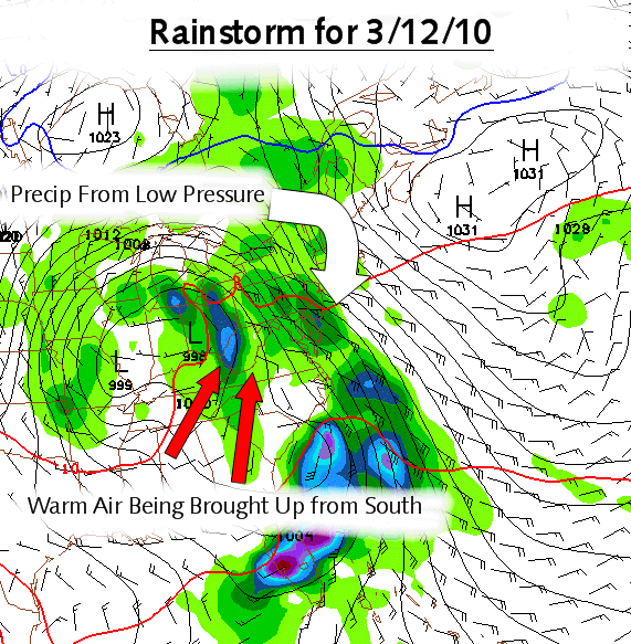
Anyway, here is a map I made for the next storm coming later this week:

Rain Map for 3/12/10

Forecast for Tuesday the 23rd and Beyond


Here is the forecast:

Tonight: Mix changing to freezing rain, then to just plain rain. Winter Weather Advisory out for Bucks, Montgomery, Hunterdon, and Somerset for the risk of ice.  Low 33

Tomorrow: Drizzle and occasional steady rain throughout the day. Warmer. Hi 41

Tomorrow Night: Intermittent snow and rain showers; little or no accumulation Low 32

Wednesday: Becoming mostly cloudy after the morning… nice day to take a break from the precipitation falling from the sky. Hi 43 Low 30

Thursday: Chance of snow showers after noon. Becoming steady by nighttime. Possible Blizzard at night. Hi 36 Low 27

Coming tomorrow: Will the NAM model verify its blizzard scenario for the area on Thursday night/Friday? Updates on the unsettled weather, and the forecast.

Forecast for Monday the 22nd and Beyond


Sorry guys that I haven’t updated all day, its just been really busy for me lately…I promise I’ll be back full force tomorrow afternoon with my time-line of the next RAINstorm. Yes, it turned out that my map was right on about the upcoming storm. This upcoming week has been one of the hardest to forecast of the whole winter, I have no idea what is going to happen. The only thing I DO know is that there won’t be much sun for the entire week starting Monday and we are looking at THREE storm systems in our vicinity this week! And that leads up to my forecast:

Tomorrow: Mostly cloudy throughout the day, rain arriving late Hi 41

Tomorrow Night: Rain, steady at times. Total rainfall of 1/2 inch. Low 34

Tuesday: Tuesday is in question… rain will slow down; drizzle throughout the day. Rain will pick up again at night from the second storm (maybe a mix in the northern coverage area) Hi 40 Low 32

Wednesday: Rain will slow up and maybe end as snow (that is a big maybe!!). Another lull of precipitation throughout the day with the third system arriving at night with rain (or mix) (or snow)! Very much in question. Hi 38 Low 32

What’s coming tomorrow you ask? The week past in review, the temp and precip compared to average of last week, and more on these very puzzling storm systems approaching our area!

Forecast for Wednesday February 17th


Here is the forecast:

Tonight: Partly cloudy skies becoming clear overnight Low 21

Tomorrow: Clouds with occasional sun peeking through. A little windy.  Hi 34

Tomorrow Night: Clear with the winds dying down Low 22

Thursday: Sunny skies with little wind. Hi 38 Low 23

Friday: Getting to 40 degrees for the first time in a while with sunny skies Hi 40 Low 25

Coming tomorrow: Explaining how the solstices work and how it relates to our weather and a forecast

Forecast for Monday Feb 15 and Beyond


Hello everyone, sorry for the late forecast, pretty busy tonight:

Overnight: Clear skies for the most part Low 18

Tomorrow: Mostly sunny in the morning making way to cloudy skies by the afternoon Hi 32

Tomorrow Night:  Snow arriving after 7:00 PM, continuing through the night Low 27

Tuesday: Morning snow tapering off by the afternoon Hi 33 Low 22

Wednesday: Mostly sunny, nice day for some of that snowpack to melt! Hi 35 Low 21

Coming up tomorrow morning on the Philaburbia Weather Blog: The past week in review, new revelations (if any) on the next storm, and the daily forecast.

Forecast for Sunday February 14th


Hello everyone, the clipper storm is coming up fast to give most of the area north of Philadelphia a nice 4-7 inches of the white stuff. Now to the forecast:

Tonight: Partly cloudy skies and cold. Watch for refreeze. Low 21

Tomorrow: Partly cloudy with a few peaks of sunshine Hi 32

Tomorrow Night: Becoming mostly cloudy late. Low 16

Monday: Mostly cloudy throughout the day watch for snow north of Philadelphia, wintry mix south. Hi 31 Low 24

Tuesday: Snow winds down by noon. Then clearing up by nighttime Hi 31 Low 20

Coming later tonight: What is a Clipper storm by correspondent Brett

3 Day Forecast for Friday Feb 12th


It was a beautiful day today, not a cloud in the sky. Some people around the area have almost three feet of snow on the ground from this past storm and the February 6th storm. Even though the next few days will be bitterly cold, the sun will help melt the snowpack slowly and steadily, preventing any flooding issues around the area. Now to the forecast:

Tonight: Clear skies and cold Low 18

Tomorrow: Another beautiful day in the making, still a little breezy Hi 32

Tomorrow Night: Clear skies Low 19

Saturday: A low pressure system passes South of us, clouds shouldn’t make it to the coverage area. Hi 30 Low 18

Sunday: Sunny with a few high clouds. Becoming partly cloudy at night. Hi 33 Low 20

Coming up later tonight: Clipper system passes through the area Monday, Jim Kosek, and NAO values

Forecast for Thursday Feb 11th and Beyond


Blog-Master Jason: Here is the three day forecast for the Philaburbia Coverage Area

Tonight: Snow ending, then becoming mostly cloudy. Watching for blowing and drifting snow. Low 24

Tomorrow: Very windy and cold. Mostly cloudy with a few sporadic peeks of sunshine. Hi 31

Tomorrow Night: Finally becoming mostly clear. Winds still persisting, though.Low 21

Friday: Sunny skies, perfect day to sled and get out of the house. Hi 33 Low 18

Saturday: Mostly Sunny and chilly. Hi 30 Low 18

Here is a satellite image of the storm right before it arrived in our area:

satellite Image of Second Great American Blizzard of 2010