Hey everyone. Just as the area is starting to recover from Sandy, another powerful nor’easter is on its way on Wednesday into Thursday. Originally, I predicted that this storm would be a mainly wind and rain event. There was just not enough projected cold air aloft to support snowfall. But, over the past day or two, the forecast models have been trending toward a more Eastern and stronger scenario. A stronger and further East storm would pull in more cold air, giving us a major snowstorm. Yes, many of you might be thinking, “This cannot be happening. First a hurricane, now snow?” We are in a very brutal pattern right now. Fortunately, after this nor’easter passes on Wednesday, the weather will calm down for a while.
There is so much uncertainty associated with this nor’easter. A shift of 20 miles east or west could change the forecast drastically. As of today, there are three possible scenarios. By tomorrow, I hope to make a final call and prediction for the storm.
Scenario 1: Storm takes benchmark. Heavy wind and snow. (European and UK model solution)
This scenario downright frightens me. Truly. I have seen the destruction from Sandy, and cannot imagine seeing more trees coming down and more power outages occurring. Unfortunately, this scenario is looking more and more likely as we get closer to Wednesday. The European forecast model is currently showing this scenario (note that the European projected Sandy correctly 9-10 days out, so we are dealing with very trustworthy data). The European brings the storm up the benchmark (100 or so miles east of NJ coast) and gives us 3-6 inches of wet, heavy snow. Much like last year’s Halloween snowstorm, this snow will create some major tree damage and widespread power outages. With both scenarios the wind will also be a factor. Our area is already under a High Wind Watch. Gusts will be near 50 mph inland and near 70 mph at the shore.

Projected snow cover (10:1 ratio) of European (note that likely ratios will be more around 5:1, so just divide the totals by 2):

Scenario 2: Out to sea; light snow
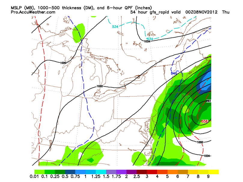
This scenario has been projected by the GFS and NAM model. It shows the storm phasing with the trough a tiny bit later than the European model. With this scenario, we would have a period of light snow and some high winds before the storm pulls away. Because the storm would be further away from the area, its effects will be lessened quite a bit.
Here is the GFS model showing this Eastern track:

Scenario 3: Storm hugs the coast: Heavy rain and wind
As of right now, no forecast model is showing this solution. A few days ago, many were in consensus for a “coastal hugger” that would give Central PA and NY snow and our area heavy rain and wind. As of today, this scenario is unlikely, but still possible.
My thoughts:
It has been truly challenging to forecast this storm. Do not listen to news outlets. For a storm like this, every model run matters. Many times, news stations do not put up the most recent or accurate forecast. Luckily for you all, the maps I am posting are 2-3 hours old… aka “fresh off the press.” 🙂
My Preliminary Prediction:
I do not like to predict snow this early in the season, but as we saw last year, anything is possible. Right now I am leaning toward the European solution, as it has been the most reliable historically. Once again, I would start preparing as soon as you can for this storm. Make sure you have the necessities to last a few days in case of a power outage. Remember, it’s much better to be safe than sorry.
