
Hello all! With a weak El Niño in place, most forecasters expected a colder and snowier winter in the northeast. Thus far, these predictions have been largely incorrect. This winter has been warmer and largely snowless for many areas. Recent signals, however, have hinted a pattern change toward a colder pattern into Febrary. This shift begins with a large storm system impacting the northeast tomorrow into Sunday.
The forecast is difficult, with a classic battle between warm and cold air assembling over the I-95 corrider. As a result, the margin determining a full fledged snowstorm, icestorm and rainstorm is extremely small. This tight setup is shown below from the short range model:
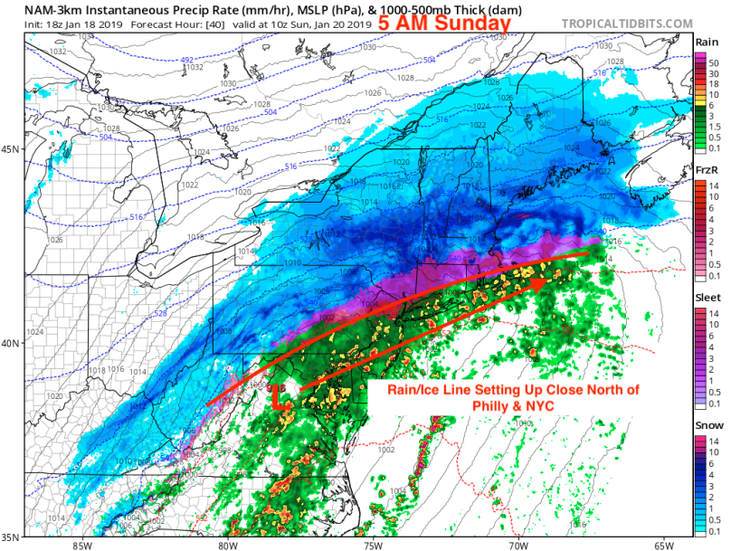
This model directs the storm off of the NJ coast during the day on Sunday. In northern areas like upstate NY and New England, ample cold air aloft will keep the primary precipitation type as snow. In areas further south, the oceanic influence will bring warmer air into the upper atmosphere, changing snow over to either sleet or freezing rain. Currently, this winter battle ground is forecast to occur over Central PA, the Poconos, Northern CT, and the Boston metro area. In the Delaware Valley, the amount of warm air will invade not only aloft but also at the surface, changing our precip type from snow to rain by Sunday morning. The GIF below shows the quick changeover:

While I am predicting a primary rain event for Philadelphia, any southernly shift in track will have a significant impact. If the low ends up 50 miles south than forecasted (which has happened in the past, especially with a complex upper atmospheric setup like this), then the battle ground will migrate over a good chunk of the Delaware Valley. A major ice storm would be catastrophic for the area, especially when nobody sees it coming. Therefore, I recommend observing temperature reports tomorrow into Sunday. If temperatures remain below freezing Sunday morning, then freezing rain will fall and cover any exposed surface with dangerous ice. I will provide an update tomorrow if conditions begin to look grim.
Risk of Flash Freeze Sunday into Monday
After we dry out Sunday afternoon, an area of polar air will stream down from Canada. This will cause temperatures to plunge 30-40 degrees from Sunday afternoon to early Monday morning.
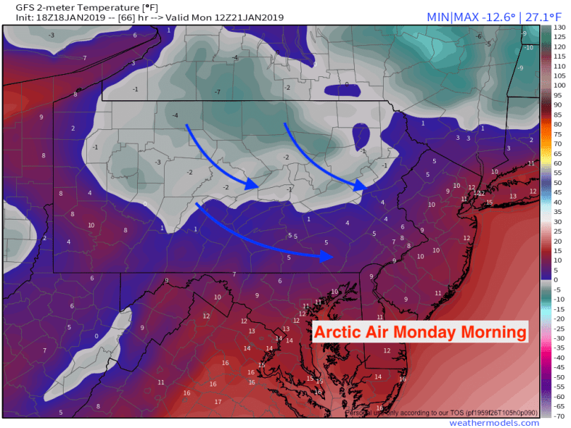
With the ground remaining mostly wet or damp, this change in temperature will cause a flash freeze on many untreated surfaces. Large areas of black ice on both roads and sidewalks are likely. Fortunately, the volume of cars on the road will be diminished on Monday for the holiday. Regardless, if you plan on driving or walking around, take extreme caution on side roads and untreated sidewalks.
Total Impacts
1-3 inches of snow Saturday evening followed by a rapid change to sleet, freezing rain, then rain by late Saturday. Precipitation will be heavy at times Sunday morning before ending in the afternoon. Rapid drop in temperature Sunday night will cause a flash freeze on any untreated wet surfaces.
