Quick Irene Update


Hi everyone. Just a quick update on Irene. Over the past day, Irene has actually decreased in intensity. She is only a category 2 storm at the moment, with 100 mph maximum sustained winds. She is expected to cross over Cape Hatteras and head up into NJ as a strong category 1. Mandatory evacuations have been ordered for the whole Jersey coast. I would still expect wind gusts to head close to 100 mph at the shore and near 80 mph in the Philadelphia region.

NHC center track as of 11 PM

The timetable has been pushed up a bit. I expect the rain to start tomorrow mid-afternoon in the form of a few scattered thunderstorms. By tomorrow night, the rain and wind will pick up. Sunday morning will be the climax of the storm, where the wind gusts will reach hurricane force. By Sunday afternoon, the rain will start to pull out and some sun may even peek through the clouds by the evening.

Because so many trees will fall during the storm, widespread power outages will occur (especially down the shore and in the suburbs) and last for days in some cases. If you still haven’t stocked up with batteries and non-perishable food, please go tomorrow morning and pick these objects up.

Be safe, Jason

Irene is Coming, Watch Out!


Hurricane Irene will be remembered for generations to come. Irene will leave billions of dollars in damage up and down the East Coast, including the major cities. Tropical Storm Watches have been issued for Mercer, Bucks, Chester, and Montgomery counties. These areas will see winds of 45 mph sustained (same wind speed for a minute or more) with gusts up to 80 mph (under a minute of the same wind speed). All of South Jersey and Philadelphia are under a Hurricane Watch. Expect sustained winds from 90 at the shore, to 70 in Philadelphia.

National Hurricane Center's Official Path

Anyone who has a house down the shore or is currently staying there needs to take extra precaution. There are mandatory evacuations up and down the Jersey shore. Get out of the shore points as soon as possible. If you stay, you will be risking your life.

I am almost equally concerned for the Philadelphia region. I expect close to 10 inches of rain to fall on Saturday and Sunday. This combined with the high winds and saturated ground will cause many trees to topple. Widespread power outages will last for days in some cases. I recommend going to the market tomorrow and picking up any necessary materials. Bring in any outdoor furniture, also tape any windows that face the North (the winds will be coming from the North) as debris will be coming from that direction.

Picture from NASA of Irene earlier today

The rain should start as scattered showers Saturday afternoon. The rain will break Saturday night before picking up Sunday morning and afternoon. The climax of the storm will be around 5-7 PM Sunday. Things should start to die down Sunday night as the storm pulls into New York City (where evacuations are likely).

Lastly, I would like to wish everyone to be safe. Our area has never seen any storm like this in recorded history. If people take this storm seriously, there will be fewer deaths and less damage.

Start Preparing for Hurricane Irene Now


Update 12:05 AM: GFS forecast model has just switched to scenario 1. Cat 1 winds into Philadelphia…

Much has happened with Irene since my last update. She has turned into a category 3 hurricane and is eying the Eastern seaboard. Still, the forecast models have  not been in complete consensus for this storm. What is known is that Irene will be a category 2 Hurricane coming up the coast. She has avoided going over any land, and will continue to until she clips Cape Hatteras. This means trouble for the big cities in the Northeast. Our environment and  infrastructure are not prepared for any storm of this magnitude. This is why I am asking everyone to start to make preparations now for Irene.

Right now there are two possible scenarios

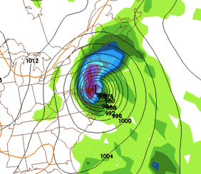
1. Here is an image from the most trustworthy forecast model, the european, for Sunday afternoon. It is showing a strong cat 1 or cat 2 storm heading up NJ. This is right now the worst case scenario for our area. Hurricane force winds along with around 7-8 inches of rain would be expected from this scenario. :

European Model Sunday aug 28th 2011

2. The other scenario comes from the GFS (another trustworthy forecast model). It brings the storm a little further east, leaving us out of the hurricane force winds. We would still receive 6 inches of rain, however.:

Irene Further East Sunday aug 28th

Both of these scenarios are possible and I am not leaning toward one over the other. By Friday, I expect Irene’s track to be ironed out and any vague details cleared up.

Finally, for anyone not aware with the Saffir-Simpson hurricane wind scale, I have provided a table below that talks about it. As you can see, even category 1 winds are extremely damaging. This is why I recommend starting to prepare now for Irene. :

Saffir Simpson Scale

I will continue to update Irene’s status as the week progresses.

Go to this webpage for more on Hurricane Preparedness: http://www.nhc.noaa.gov/outreach/prepare.shtml

5.9 Earthquake Hits East Coast


I am taking a break from the weather to talk about the 5.9 earthquake that hit most of the East Coast earlier this afternoon. The quake originated just north of Richmond Virginia. It was the largest quake in over 100 years in Virginia and one of the strongest recorded ever on the East Coast. Many office buildings were evacuated and many homes shook for 10-15 secs according to reports. For many people living on the East Coast, including myself, will not forget this rare strong quake anytime soon.

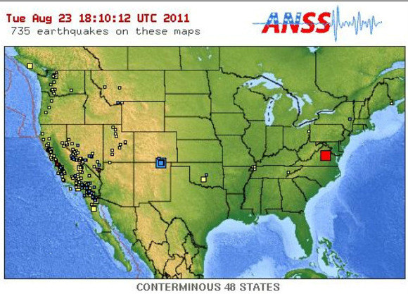
Here is an earthquake map from this afternoon. The map shows an earthquake originating in Virginia (red square):

Red Square is the earthquake that hit the East Coast

Tropical Storm Irene Will Likely Affect the East Coast Next Weekend


Tropical storm Irene has formed in the Atlantic ocean. She should intensify and turn into a hurricane before slamming into Hispaniola. I have been watching this storm for the past week or so, and it is looking more and more likely that a tropical system impact our area. Current model guidance that shows 9-10 inches of rain falling in our area next weekend. This scenario would be devastating for everyone up and down the I-95 corridor. Also, Philadelphia has received more rain this August than any other month in recorded history. I am asking everybody in the Philadelphia area to keep a watch on this storm.

Here is the infamous GFS model showing hurricane Irene dumping 10 inches of rain on our area:

Irene Coming up the Eastern Seaboard

The current challenge concerning Irene is to decipher and use dozens of computer model runs, each showing a different track, in order to draw a path for this storm. Right now, Irene will strengthen rapidly and hit Hispaniola and Cuba. After that, most models send it toward Florida and then Northeastward up the Eastern Seaboard. Because this storm is still a week out, confidence is low on the exact track of the storm. But I am confident that Irene will have an impact on our area next week. How much of an impact? Well, that remains to be seen.

Here is my preliminary hurricane map. Because of the uncertainty of Irene’s track, I have made the cone very broad, putting in all outliers into account. I am confident Irene will pass between the arrows drawn. This cone will likely narrow as we progress through the week.

Tropical Storm Irene Track # 1

I will update in a few days on the progress of Irene.


Also, there is a slight risk of severe weather tomorrow. The storms will be similar to the ones we were hammered by on Friday.


Rainy Today, Nicer Weather Later in the Week


Hi everyone. I returned home yesterday night from Boston to be greeted with heavy rains and strong thunderstorms. These showers and storms are part of a low pressure combining with the upper level trough. Over four inches of rain has fallen in Philadelphia and has created some flooding problems in the area.

Update Monday: According to the National Weather Service, Philadelphia received 4.84 inches of rain Sunday. This was the 4th highest single day rain on record, behind Hurricane Floyd in 1999 (6.63 inches) and others.

By tomorrow, the rain should become  more scattered. By Tuesday, we could see some sun later in the day! Temperatures should stay in the mid 80s for the rest of the week before another low pressure system passes through next weekend. This low has the potential to be influenced by a tropical system heading up the east coast. If this scenario comes true, our area could be in for a healthy soaker (more rain than this weekend). Right now details are vague and confidence is low, especially with the tropical system (since it doesn’t even exist yet).

Here is the continuously updating radar for your convenience:

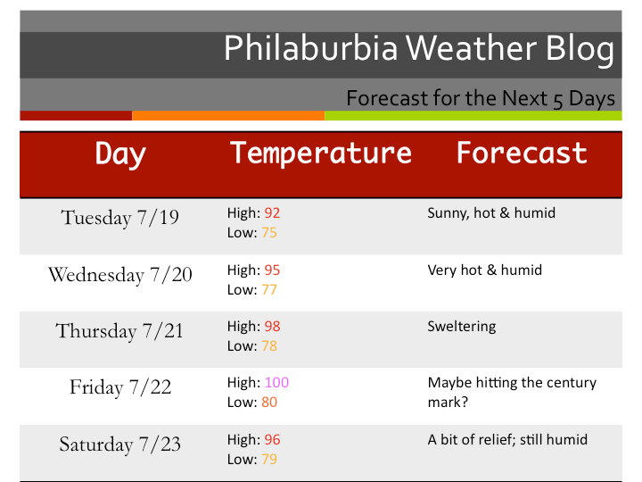
And here is the five-day forecast:
Five Day Forecast

Tropical Storm Emily has Formed… Will it Affect the Area?


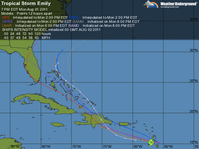
Tropical storm Emily has formed in the Caribbean, and will threaten the East Coast this coming weekend. Emily will cut through the Dominican Republic and the Bahamas before cutting North and then Northeast. Right now, the position of Emily all depends on a frontal boundary that will pass through later in the week. If the boundary is weaker and comes in later, Emily will go further Southeast and threaten the East Coast. If the boundary is stronger and faster, then Emily should go more Northeast and will not be a threat to land.

Right now, the models are pointing to a more South and East track, but the tract will likely change over the next few days.

Model tracks for Emily

Temperatures will improve Wednesday (low 80s) before going back into the 90s for the weekend. July 2011 was the hottest month on record for the Philadelphia area. August doesn’t look much better.

Heat Wave to Remember this Past Weekend; More Coming


Extremely hot temperatures plagued the area this past weekend as records were broken on Friday, Saturday, and Sunday in the area. These temperatures will probably be the hottest of the year and even for years to come. Philadelphia hit 105 degrees on Friday. This was just one degree shy of their all time high of 106 degrees.

For the next few days, look for the heat to subside as the Bermuda high moves out. The heat will return later in the week as the Bermuda high will move back in and bring back the southern air.

Heat Wave Stats

Tropics:

Tropics have been fairly quiet right now. There is one invest that is worth noting in the Caribbean. If this disturbance were to organize into a tropical system, it would head into Southern Texas/Mexico as a hurricane.

Get Ready for Extreme Heat This Week


It is going to get very hot later this week as a powerful high pressure set up in the Midwest will bring in warm and humid southern air. Temperatures will be in the upper 90s or maybe even 100 degrees later this week. There is no rain in sight after tonight (some nasty storms could pass through the area tonight), so plants and trees could start to show signs of wilting by next weekend.

Forecast

I also wanted to talk a little about the tropics, as it is starting to heat up. We have Tropical Storm Bret out in the Atlantic right now. It shouldn’t be any threat to land, other than the Bahamas. There have been signs of late that another storm will form next week… details are vague at the moment. As of right now, it is looking like an active hurricane season coming up this year.

More Classic Summer Thunderstorms Today


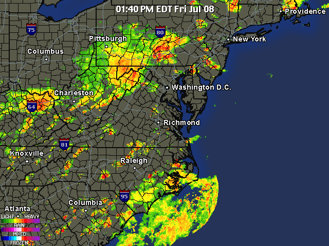
Hi everyone. Well we have another day with severe storms in the forecast. The last few days have had more isolated storms, but today a more widespread event is expected. A frontal boundary associated with a low pressure system is expected to pass through our region later today. Combine the ultra high dew-points with the instability from the front, and we get some fairly nasty storms. Right now there is a flash flood watch for the area because of the slow movement of the storms. Two inches of rain could fall in less than an hour for some of these storms!  Expect more storms to pop up and intensify as we head into the late afternoon.

Tomorrow should be much nicer then today as we finally get some relief from the hot and humid weather.

Here is the radar as of 1:40 PM. For continuous radar updates, check out the radar tab at the top of the site.

Storms Today