After Another Bust, A New Storm is on the Horizon for Christmas


Well, the storm that I talked about earlier this week that had some potential for snow turned out to be another bust for the weather models (specifically the European). BUT!! We have another storm that has a decent chance of at least giving us at least 1-3 inches of snow.

A clipper is expected to pass through the area on Christmas Eve. This would give us a base total of 1-3 inches. The big question is whether this clipper will ride the trough and blow up into a major snowstorm. The unreliable GFS model has been showing the clipper turn into the nor easter for maybe 6-8 runs now. Many other models are starting to show it as well.

Here is the GFS 12Z from today:
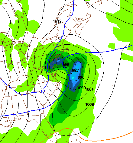
Christmas Storm Speculation

And here is the European Model:

EURO Christmas Storm

Right now, it is looking very favorable for snow. The pattern is looking very good and the upper atmospheric troughs seem to support a Clipper transitioning into a Blizzard. I will not be announcing snowfall total estimates until Wednesday.

I will say that we will get snow Christmas regardless of whether a Nor Easter forms or not. The Clipper will still move through, but the question is whether this Clipper rides the coast or stays out to sea.

A storm (maybe) this Sunday (maybe)


As I have been telling people this whole week, meteorology is just  bunch of maybes.

After one of the most epic busts in recent memory from the last storm, we look ahead to our next snow chance: Sunday the 19th. Yes, the best case scenario (if you want snow) would be a 15-20 incher with a full blown blizzard. I’d say the chance of this happening is fairly low at the moment. Right now we are looking at a 6-10 incher with less wind.

One thing is for sure: WE WON”T GET RAIN!! The setup of this low pressure with blocking highs in Onterio prevents this thing from going inland. Like always we have TWO scenarios. The first takes the low up the coast as a nor-easter snowstorm giving us a good deal of snow. The second scenario sends the low out to sea, giving us a bright and sunny Sunday.

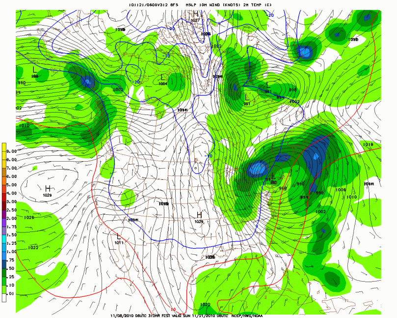
Right now most models are going with a coastal solution, hence the reason I am writing this post:

GFS 12z: This model is showing a major snowstorm (12-20 inches) for our area:

Major Snowstorm Solution

There are many other possibilities for this storm. The image above I would call the best case scenario for a snowstorm.

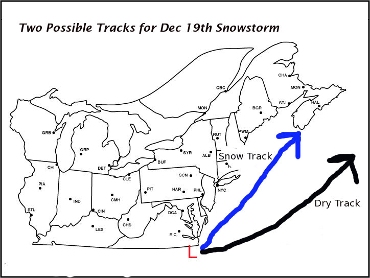
Here are the two possible tracks:

Two Tracks for Upcoming Storm

Betting for Snow Would be Against the Odds at the Moment


I have concluded that all the computer models are going out of their minds right now. Every run seems to be drastically different from the rest.

It seemed throughout the day today that we would be definitely having a rainstorm. The 18z runs changed this prediction. They showed a more snowy solution, which shows that anything could happen with this storm at the moment. I have made a preliminary track map of the storm (Don’t criticize my lack of Photoshop experience) that shows the two possible tracks of the storm:


Prelim Map

Right now I would say there is a 70% chance that this storm will take the rainy track and 30% chance that this storm will take the snowy path. The numbers are subject to change as we get closer to the 13th. These tracks are the outliers for the models, a most likely track would come in between these tracks; giving us snow at the onset, then changing to rain before changing back to snow at the back-end.


My current prediction: I will not make a prediction until Thursday because of the great uncertainty at the moment. I would say that the big blizzard solution is pretty unlikely right now, but you never know what could happen over the next few days.

I’ll be updating tomorrow on the progress of this storm

Adios

Many Questions Need to be Answered


This upcoming storm could be one of the largest snowstorms ever in December history, or it could be one of the largest rainstorms in December history. My job is to try to decipher which one it will be. Many people have asked me if 12-15 inches is a realistic estimation for this storm. As of the computer model trends right now, this is DEFINITELY NOT a realistic estimation. Most weather models seem to be in consensus with each other for a storm that’s 7 days away (which is pretty ridiculous if you ask me).

They are showing a low pressure system chugging along the jet stream and riding it into the Great Lakes, bringing in warm air from the south and making this snowstorm a gigantic rainstorm (2-3 inches of rain). I know this won’t excite many people and will probably be a big disappointment, but right now that’s how this storm is being portrayed.

Here is a latest weather model (18z GFS) from today. It is showing the storm riding the jet and bringing snow to Chicago and rain to the Philaburbia area:

Dec 13 Storm

Do not lose hope on this storm. It is a week away; I have seen plenty of storms go from a Great Lakes Cutter to a gigantic Nor-Easter on the weather models (example last December 19th). As we get closer to Dec 13th, the trends of the weather models will give us a better prediction of what this storm is going to turn out doing. Right now the trend is west, but in a few days it could shift 500-600 miles east (I’ve seen it before!) and turn into the 12-15 incher I was talking about yesterday. I will post again tomorrow and talk about the trend and whether we still have a chance at this storm.

We May Have A Snowstorm on the Horizon!!


Hi everybody. I’m sorry for the lack of updates recently, I feel I have let my readers down. 😦

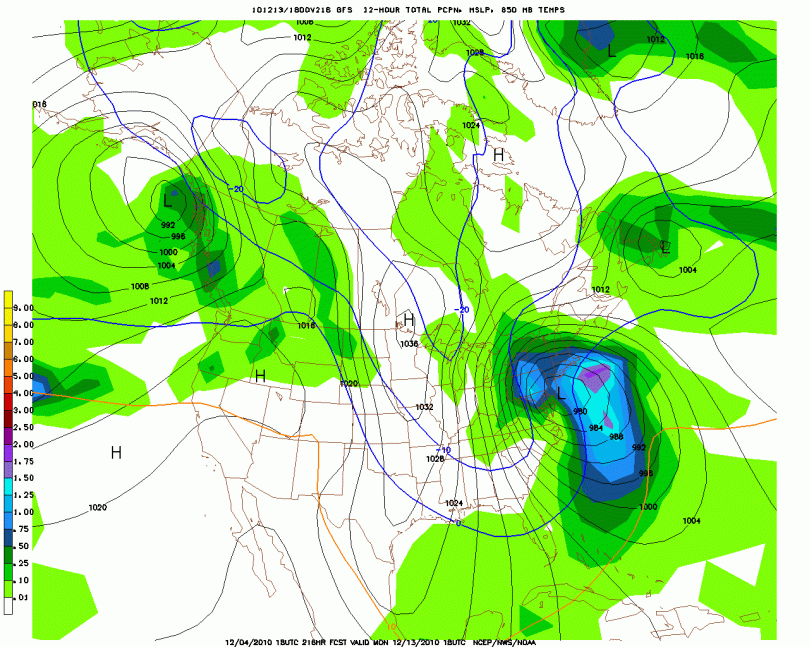
Ok let’s get to the weather. I have been telling a few classmates at school this past week about a snowstorm/pseudo-blizzard that will hit next Monday (December 13th). I am extremely excited about the latest computer model run from today showing our area getting 12-15 inches of snow Sunday night into Monday night.

18z GFS computer model, at 216 hours (Around 4 PM Monday afternoon):

This model run is very important for the future of this storm. Many experts have been calling this storm for the past week hence the reason I have been informing a few of my classmates about it. This is the first model run from the GFS that is showing a full-fledged storm hitting our area. We have a negative NAO (North American Oscillation) predicted for that time frame. Negative NAO values generally indicate some kind of low pressure crossing the country or a nor easter. The large rainstorm we just had earlier this week made the NAO values tank. What intrigues me about the December 13th storm is the abundance of cold air that will be in the area during that time frame. The last storm didn’t have enough cold air associated with it hence the reason we received a ton of rain.

For this upcoming storm, everything is seeming to fit together perfectly, which doesn’t happen too much in the weather world. We got neg NAO, cold air, a storm system, and some model agreement 9 days out.

On a more serious note, weather is very unpredictable; we are relying on a bunch of computers to predict the future. There is always room for this storm to be a bust.

I will post a prelim SNOW MAP(!!) by midweek if the models are still showing the storm. If this storm DOES come through and we get a snowstorm, I would say 6-15 inches would fall on the area guaranteeing 1 or 2 snow days for many schools.

Forecast and Upcoming RAINstorm


I hope everyone is enjoying the nice weather and seasonal temperatures over the past few days. I want to look ahead to our next storm system, which is looking to come next Tuesday or Wednesday. Forecast models have been showing a low pressure cutting through the Southeast and into the Northeast. Let me make it clear: this will not be a snowstorm! We just do not have the cold air and the sun angle for a snowstorm. After looking even further ahead, it looks like we won’t be even thinking about snow until after Thanksgiving.

Here is my forecast prediction of next week’s storm:

Preliminary Map for 17th Storm

And now for the forecast:

Friday: Sunny and warm High 60 Low 40

Saturday: High pressure in control High 61 Low 40

Sunday: Sunny in the morning, becoming partly cloudy by the afternoon High 62 Low 39

Monday: Partly to mostly cloudy becoming cloudy by the evening High 59 Low 41

Tuesday: Rain arriving in the morning High 60 Low 49

We Look to the Future


Hello everyone. As the title of this post says, we will be looking at what’s going on in the long range forecasts. For the next 9 days we will be having beautiful (and warmer) weather in the area as high pressure will rule for the most part to our north and south. As we head into next Wednesday however, a low pressure will form in the Gulf of Mexico. It will then cut through the southeast and dart northeast. This type of path is very similar to what we saw in some of the large noreasters last year.

Now the storm after that is looking to hit on the Sunday or Monday before Thanksgiving. This storm has shown up on two straight GFS’ runs. This is extremely rare for a storm so far away to show up on two straight model runs. I do believe that there will be a storm around that time period but I have no idea who it will effect. These details will get ironed out as we get closer.

Future Long Range Storm

I will of course keep you updated on these two upcoming storms as time progresses. Otherwise enjoy your 9 days of nice weather, because it’s gonna get rough after that!

Just Drizzle for Thursday; Then Prolonged Nice Weather


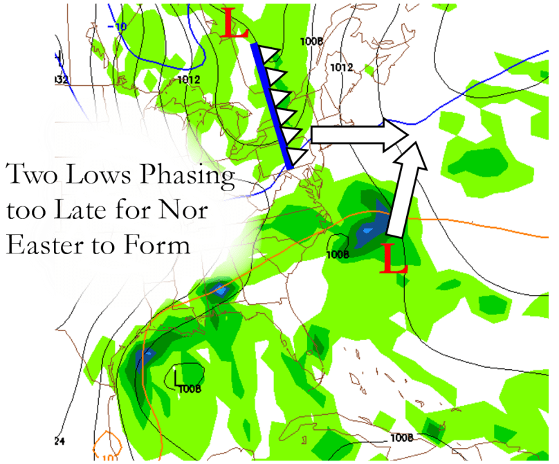
As it looks now from the latest computer models, the presumed “Nor Easter” that was expecting to arrive this coming Thursday will not be as much of a weather event as I had hoped. The two low pressure systems that were expected to phase (join together as one larger storm) before passing by our area are now looking as if they won’t join together until they pass north of the region. This would only give us cloudy skies and a few showers to accompany cool, raw temperatures.

Here is a map I made to illustrate why we won’t be dealing with a full-fledged Nor Easter this coming Thursday:


11/1/10 Storm


The rest of this week is looking to have highs in the 50s and lows in the mid to lower 30s. In the long-term, we are looking at a few storms that could give us some trouble later this weekend and into next week.

If any other details or changes arise from the upcoming storm, I will make sure to post them here. Otherwise have a nice night!

Feeling More Like Fall


After a week of warmth, cooler weather has settled into the area. A large high pressure system in Canada will bring in below average to seasonal temperatures this week. We are also watching a possible Nor Easter for mid-week that would give us a rainy and windy Wednesday and Thursday. This storm will obviously not bring snow to the area, but it is a preview of what could be a major snowstorm in January or February.

Trick or treat forecast: It is going to be a fairly chilly Halloween this year with temperatures dipping into the 40s by the evening. Wear layers or a coat when you’re trick or treating and collect as much candy as possible!

Monday: Sunny and chilly High 47 Low 34

Tuesday: A repeat of Monday Hi 48 Low 33

Wednesday: Sun to clouds. Nor Easter at night? Hi 51 Low 35

Thursday: Nor Easter? Hi 50 Low 42 (Note, high temperature is subject to change dramatically depending how far the Nor Easter is off the coast)

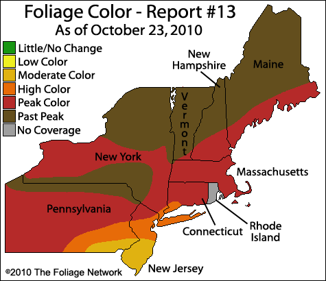
And we will conclude today with the Fall Foliage update: As you can see, our area is at its peak color for the fall. By the end of this week however, we should be past peak color:


Fall Foliage 10/30


Back in Action!


Hey everyone… I was pleasantly surprised to see people still visiting the dormant website over  the past few months. This will be the first post of many for Philaburbia Weather’s 2nd winter season. There will hopefully be some new features in the upcoming months including a new look to the site, maybe a twitter to the site, and even an iphone app (maybe :)).

And now to the weather:

Today was one of the warmest days on record, with the temperatures reaching into the mid to upper 70s in spots. Tomorrow will be one of the last nice days of the year until the real cold starts to move in from Canada over the next few weeks.

Tonight: Becoming clear late Low 54

Thursday the 28th: Mostly sunny and warm Hi 74

Thursday Night: Clear and much cooler Low 45

Friday: Much cooler and windier. Sunny. Hi 55 Low 34   WATCH FOR FROST

Saturday:  Cool and sunny Hi 57 Low 39

Also we will probably have a Frost Advisory issued for Friday night as the low will drop into the lower 30s.

I’d like to end today with a map of the current fall foliage going on in the Northeast:

Current Fall Foliage Map