My Concern About the Ocean Temperatures


I am becoming more and more concerned and worried about the latest ocean temperatures for the majority of the east coast and Atlantic Ocean. I have had fellow blogger Brett Wiley introduce me to this startling observation, and as well have read about it on some other blogs as well. According to NOAA, the ocean temperatures off the east coast are well above normal. Water temperatures are currently in the mid 70s along the Jersey coast and continue to be above normal all the way down to Florida. As many people know, we are heading into the peak hurricane time-period in a month or so. Hurricanes thrive over warm ocean temperatures, part of the reason why most of them reach their strength in the Caribbean or in the Gulf of Mexico (where water temps are in the 80s and 90s). Usually by the time the hurricane reaches the cooler waters around our area, it weakens substantially and speeds up in the process.

Here is the map of the temperature anomalies for the Atlantic Ocean. Green, yellow, orange, and red represent above average temps:

Anomalies for Atlantic Ocean

Atlantic Ocean temperatures peak in mid August and usually end up reaching the mid-upper 70s. If we are already experiencing temps in the mid 70s, and it’s only July, we could be having temperatures in the 80s by the time August comes around. This is what scares me. If my prediction comes true, then hurricanes may not weaken if they move into our area.

I will continue to monitor the situation in the Atlantic for the next few months.  Stay tuned to Philaburbia Weather for the next few months.

First Tropical System of the Season!!


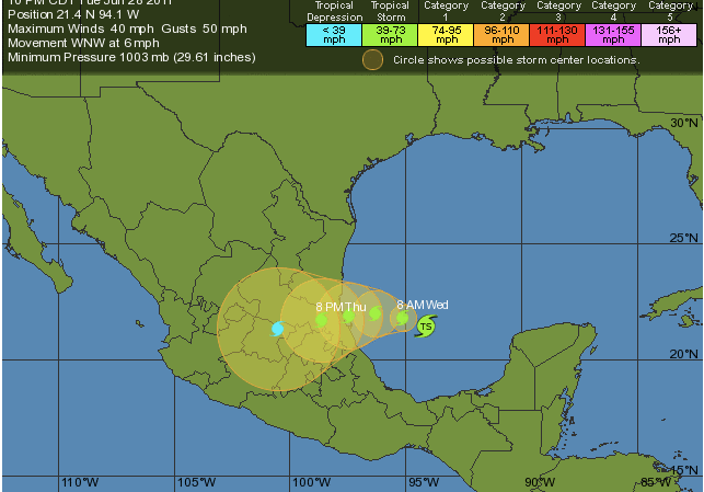
Well, it’s late June and we have our first Tropical Storm of the season. Arlene is located in the Gulf of Mexico and will most likely slam the Mexican coast before dissipating over Mexico. It shouldn’t have any threat to the US mainland whatsoever. If any details change about Arlene, I will let you know. For right now, however, I wouldn’t start worrying about this one.

Arlene and Path

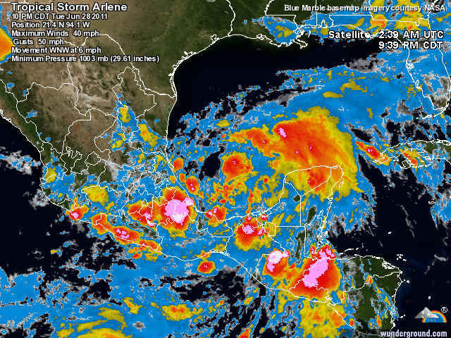
Here is the current radar image of Arlene. I wouldn’t expect her to get much more organized in the limited ocean space she currently has:

Sat Image of Arlene

After Damaging Storms Yesterday, More to Come Today


There were a few nasty thunderstorm cells that pulled through the area yesterday. One passed through Montgomery and Bucks counties, before eventually dissipating over New Jersey. The other storms passed through South Jersey, where one death was confirmed by the National Weather Service. Both of these storms created problems for residents in the Philadelphia area. There was one report of a house almost catching on fire from a lightning strike in Newtown, PA. In Hatboro, PA there were reports of multiple trees down, and in Ocean County, NJ, there were reports of power lines down.

The storms that hit yesterday, as I said in yesterdays post, were scattered. It will be a similar story today. Right now skies are cloudy in much of the area, but as the clouds burn off during the day, strong thunderstorms will pop up during the afternoon hours. These storms will look similar to the ones that hit yesterday. I would expect strong winds, hail, and some minor rotation where they hit.

Sim Radar 6/23

I will update as the day progresses

Stormy Weather for the Next Few Days


UPDATE 3:15 PM Wednesday: There is a Severe Thunderstorm heading to Bucks and Mercer counties. Right now it is over Lansdale, Montgomery County. Expect it at Doylestown at 3:35 and Richboro at 3:50. It will be in NJ closer to 4:15. If you hear thunder, move indoors immediately!


After a fairly quiet week and a half, we are going back to the stormier pattern for the end of this week. A frontal boundary to our north has brought in an unstable air mass, which will harvest strong thunderstorms and some isolated super-cells for the next few days. These storms will be widespread, but scattered. Philadelphia may get 4 or 5 severe storms over the next few days, and Doylestown may get none. It really all depends on location. As I’ve said in previous posts, keep your eyes to the skies. If you see any dark clouds approaching, move inside and secure any outdoor furniture. These storms have the potential to cause a decent amount of damage where they hit.

Here is the simulated radar for later today. According to this model, parts of the area would be experiencing a severe thunderstorm (as shown by the yellow color over the Philadelphia area):

Sim Radar for 6/22

As of right now, there are two cells of concern that are approaching the area. One is in northern Montgomery, moving east. The other is just north of Baltimore, moving almost stationary. I expect that more storms will be flaring up as the day progresses, so I have posted a live radar on this post to keep people informed.

Live Radar

Live Radar

Severe Storms Later Today


Temperatures are going up near 100 right now as the heat and humidity build in front of a major scuall line heading down from the Northwest. As of right now, there is a Severe Thunderstorm Watch for the area until 10 PM. There is currently a high risk of hail and high winds in excess of 70 mph.

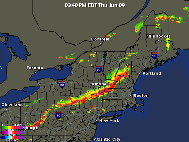
Here is the current radar as of 3:45 PM

Thunderstorn Line

The squall line will reach the northern parts of the area at around 6 PM and move out of the region by 7-730 PM. Please keep a watch on the skies. If you see dark clouds, get inside immediately! These storms are extremely dangerous and will pack quite a punch where they hit. I will continue to update as the storms get closer

It’s Going to Get Very, Very Hot


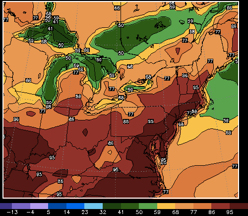
Heat Wave #2: It will be a bad one. After the last week of beautiful weather, it is only mother-nature-like to have a nasty heat wave right after. A very hot air-mass from Mexico will be moving into the area tomorrow, raising the temperatures into the low 90s. By Wednesday, the high could get to 95-96 degrees as the air-mass parks itself over the region. The hottest of the three days will  undoubtedly be on Thursday, where the temperatures could reach 100 degrees! Truly amazing stuff for early June. There is an Excessive Heat Warning out for the area, as the air quality will be unpleasant to say the least.

Here is the NAM’s predicted temperatures for Thursday afternoon. The scale only goes to 95 degrees, and it is showing temperatures hotter than that.

Heat Wave #2

And here is the forecast:

5 day Forecast 6/7-6/12

Record Warmth Monday, Nice for the Rest of Week


Ahh, finally. Some warm weather. This time is probably the least busiest of the year for meteorologists in the Philly area. Hurricane season hasn’t started, snow is over, and the severe weather season hasn’t really begun. After a LONG winter of stress and anxiety, I am ready for the well deserved break.

Tomorrow highs will climb into the 80s. The sun will be shining and a light southerly wind will bring in a warm breeze. Records will be shattered tomorrow in the area. In Philadelphia, a record could be broken for more than a hundred years ago!

There will be a chance of some strong to severe storms tomorrow evening however as a cold front will sweep by the area, bringing temperatures for the rest of the week into the 60s (still not bad though).

I am a little concerned that some of the storms tomorrow could be stronger than what the news stations are currently advertising. Warm air will obviously be in place, destabilizing the atmosphere. By the late afternoon, I could see a very formidable squall line barreling across Pennsylvania into the Philaburbia region. Just keep an eye to the skies tomorrow after 4 PM because you never know what might pop up.


Slight Risk of Severe Weather Monday


A Little Snow Tonight, then A Mixed Bag on Friday


The next two days will not be the nicest. Tomorrow will be cloudy with an occasional snow shower or rain shower passing through the area. Accumulations will be limited to grassy surfaces.

The Friday storm has finally ironed itself out. It is looking to be a general 2-5 inch storm with rain at the onset (Thursday Night changing to snow by Friday morning. It will not be a nice day. Some roads could be pretty slick during the day on Friday so I would recommend taking it slow. A Winter Weather Advisory will probably be issued tomorrow for areas north and west of Philly.

Here is the general timeframe of the storm:

8:00 PM Thursday – Midnight Friday: Rain moves in from south to north

12:00 AM – 2:00 AM: Rain will eventually mix with snow and turn to all snow north and west of the city

2:00 AM – 8:00 AM: Snow (rain south of the city) will start to wind down and end by noon Friday

Here are some snow totals with no snow map (I have been having problems with the application I use for the map):

Bucks, Mont Co, Mercer, Chester: 2-4 inches

Philly south: 1-3 inches

Lehigh Valley: 6-8 inches

Note that these totals can easily change and areas closer to the city could receive more or less snow depending on the storm track.

April Fools Day Storm; Yes, it Will Involve Snow


Here is my agenda for this post: 1. Talk about storm tomorrow night 2. Talk about the big one on April Fools Day 3. 5 day forecast

1. We will be getting a coating to an inch of snow, especially north and west of the city tomorrow night as a weak low pressure system passes to the south of us. Nothing to worry about with this system because nothing should stick to the roads whatsoever.

2. Now, for the Friday storm. I have been talking about this one for a while now and it has finally started to shape out the way I had thought. The GFS model has generally been on board for a fairly major snowstorm Thursday Night into Friday. Other models have been showing a more rain and snow mix, which would lower our snow totals drastically. Right now I am leaning toward the snowier solution. My early call right now is for 4-8 inches to fall Thursday Night and Friday. There will be higher totals in higher elevations. The snow will be wet and heavy; power lines and trees have the risk of falling on Friday. Because we are still 3 days away from the storm I will not post a snow map just yet. And yes, there could be school closings on Friday.

Here is a projection from the GFS of the snow. This is at 5 AM Friday and will be most likely the most intense part of the storm:

April Fools Day Storm

And now the 5 Day Forecast:

The Five Day Forecast

Snow map and update tomorrow!!!

New Formatted 5 Day Forecast: Two Storms Coming this Week


Hi everyone. After over a year of doing Philaburbia Weather, I finally have a presentable 5 day forecast template that I will use.

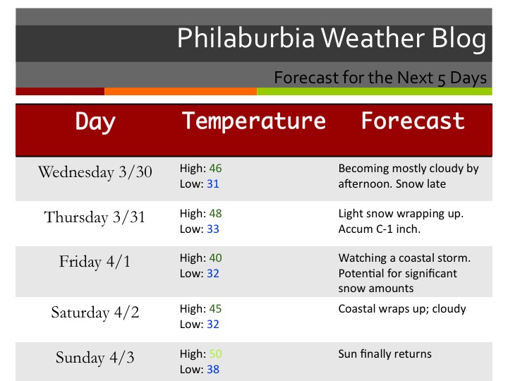
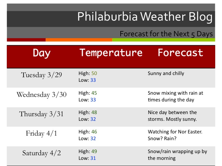
Okay, now to the weather. A very complex weather pattern is about to start with a possible 4 day period of storms. A few models are showing a storm on Wednesday. At this point, the general consensus is for this storm to ride out to sea and give us a few snow showers during the day on Wednesday. There is a chance that this storm heads further north and gives us a bit more snow than expected, but right now it is looking more like a minor event.

The second storm on Friday is the one to watch. It has the potential to really cause major traffic problems in all of the major cities. It’s going to be a close call for the precip type. As of right now, it is looking to become a Nor Easter and give some sloppy wet snow. The snow will mix with rain at some point during the storm; the question is how much rain will actually mix? The GFS model (one of the most trusted mid range models) is giving us 3-6 inches of heavy sticky snow. Another model is showing a major rainstorm with totals climbing close to 2 inches. Keep a watch on this storm on Friday, because it could cause major problems for the Philly area.

Ok and finally, my five-day forecast… in style (click to enlarge)!

5 Day Forecast 3/29