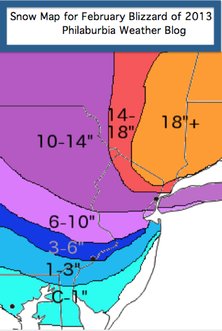
Well, the storm is nearly here, and it seems that most forecast models are in agreement for this upcoming storm. Since yesterday, there has been a trend toward a faster phase between the two lows tomorrow afternoon. As a result, I am bumping up snow totals for areas north of Philadelphia. A general 3-6 inches should fall in the city and its immediate suburbs. Central and Upper Bucks, Mercer, and Hunterdon will get 6-10 inches. In New York City, blizzard conditions are likely with totals reaching over a foot. Up in Connecticut and Massachusetts, final snow totals could come close to 30 inches! Without a doubt, this storm will be one of the strongest we’ve seen in the last 20 years.
Snow Map for February Blizzard of 2013
Timing:
Around the Philadelphia area, precipitation should start out as rain tomorrow afternoon. By tomorrow night, snow will start to mix in from north to south. By 2 AM Saturday, heavy snow should be falling for the whole Delaware Valley. The snow should end by Saturday morning.
Roads will be slick Saturday morning, especially in the northern suburbs. I would not recommend driving on the roads until noon or later on Saturday. High winds will also accompany this storm with gusts reaching 40-50 mph. Stay safe everyone. My next post will likely deal with the next storm coming on Valentines Day… until then…
Hey everyone. The lack of posts for the past month have been partially my fault. College has been very time-consuming and it’s hard to find a time block to write a quality post. I am, however, taking a break from my studies to discuss the next storm coming this Friday and Saturday.
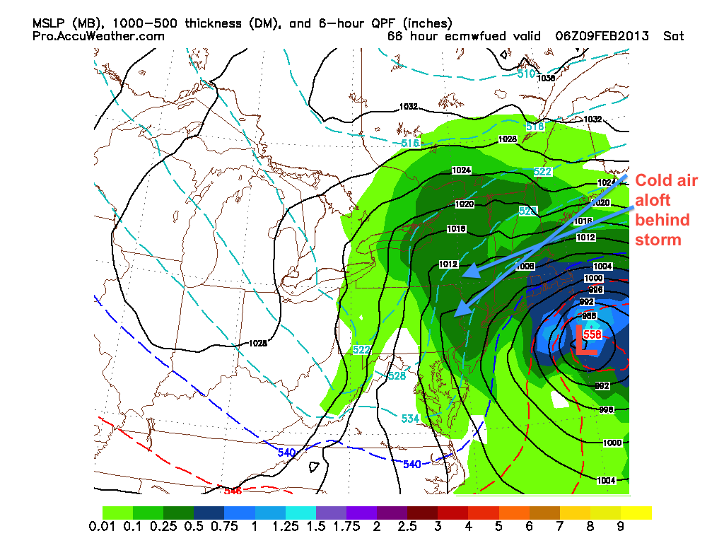
This will a big one. Two fairly strong systems will phase off the coast of NJ and create a large nor’easter with blizzard conditions from NYC to Boston. For the Delaware Valley, this will be a minor storm in terms of snow. The phase is occurring way too late and there will not enough cold air aloft for snow to fall. The graphic below shows the European solution at 1 PM Friday. This is right before the storms phase. As you can see, not enough cold air is available to support snow for the area (represented by the blue 540 line).
Before Storms Phase
As the low pressures phase and strengthen, cold air aloft will eventually get wrapped around the storm. This will help change the rain to snow from north to south in the Delaware Valley, while creating blizzard conditions in New England.
European model 2 AM Saturday
The crucial component of this storm will be the timing of the phase. The slower the phase, the less snow for places south and west. If the phase occurs quicker than expected, then the changeover to snow could occur much sooner than the European model is showing above.
Timing-wise, rain should start falling Friday evening and changeover to snow early Saturday morning before trailing off. Snow totals are extremely difficult for the Philadelphia area because they rely completely on the phase timing. Right now I am calling for 3-5 inches to fall in the immediate Philadelphia area, with higher totals in Mercer county and upper Bucks. Overall, the consensus for the models is pretty good. The NAM model phases the low pressures much later, while the European and GFS phase it earlier. Over the next day, this disparity should disappear and a consensus should come. Until then…
The active weather pattern continues. The post-christmas storm proved to be a large rain and wind maker for our area. Snow reached a foot over much of Northern New York and Western Pennsylvania. There was an unexpected burst of snow at the beginning of the storm for areas north of Philadelphia, which created some slippery conditions on the roads during the afternoon hours. By the evening, the warm sector of the storm took over and temperatures rose above 32 degrees.
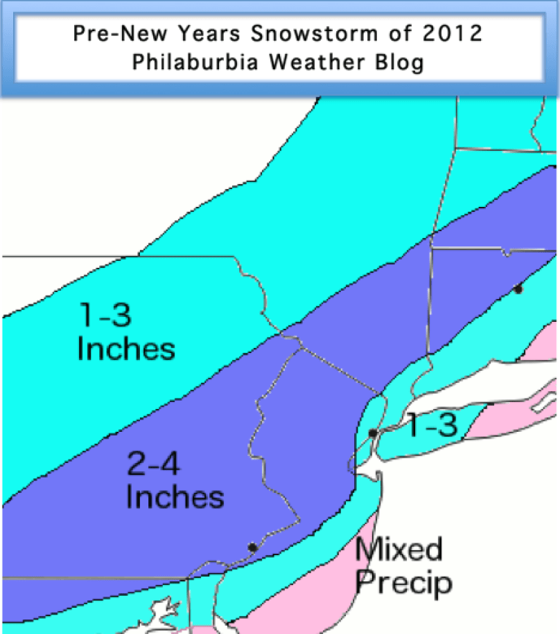
Our next storm will affect the area on Saturday. This will likely be an all snow event, with the low pressure being much weaker than the last. There are two possible tracks for this next storm. The GFS model shows a storm that hugs the coast and drops 3-5 inches of snow for much of the I-95 corridor. The NAM weather model projects the storm sliding south and out to sea. Totals would be 1-2 inches in this scenario.
Here is the GFS at 2 PM Saturday:
GFS Sat 2 PM
The NAM shows a much weaker solution, due to the distance the low pressure is from the coast:
NAM 5 PM Sat
Timing and Effects:
Snow should start falling by mid morning in most places. Snow could get heavy by 2 PM, and should start to slow down by 8 PM on Saturday. Roads should be a little dicey in the afternoon, and icing could occur at night. Keep it slow on the roads on Saturday and Saturday night.
Snow Map:
I am a bit conservative on my totals for Saturday’s storm. I call for 2-4 inches for most of the Delaware Valley. In Central PA, Southern NJ, and NYC, I have 1-3 inches. By the shore, temperatures will be too warm to support snow accumulation.
As I mentioned a few days ago, a minor shortwave clipper system is passing over the region today and will drop a quick coating on places north and west of the city. Looking at the current radar, some dynamic cooling is occurring where snow is falling in Maryland, causing temperatures to fall as much as six degrees in places. By 6 PM, precipitation will start falling in the Philly area and will likely change to snow for a time. Things should start ending by midnight and skies will clear by Christmas morning.
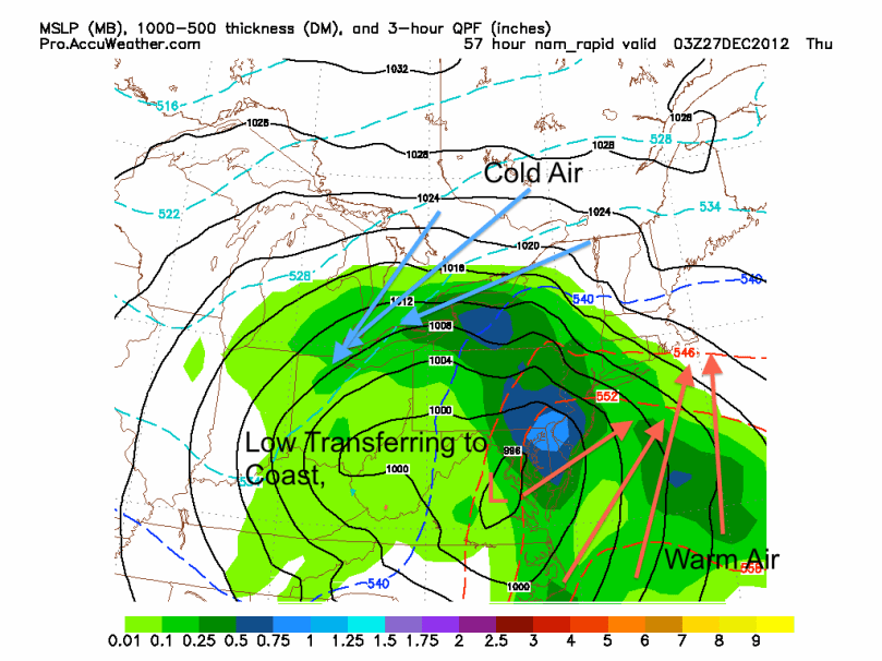
At this point, it looks like the storm on Wednesday the 26th and Thursday the 27th will be primarily rain. Most models are in consensus and are showing a strong low cutting up the Appalachians. The storm will eventually transfer to the coast, but it will be far too late to bring in the arctic air aloft to support snow for the Delaware Valley. As a result, the precip type in this storm will primarily be rain, heavy at times. There is a chance for some snow on the backside of the storm Thursday morning, but I would not expect any accumulation.
NAM Wednesday Storm
Our active pattern will continue as another storm is possible next Saturday into Sunday. The European forecast model has been showing a coastal low bringing us some decent snow totals, while the GFS model has been showing the storm out to sea. More details will emerge for this storm as the week progresses.
Hey everyone. My first semester in college is complete and the weather pattern is starting to heat up. We are looking at a very active week weather-wise. First, a clipper system will affect the area Christmas eve into Christmas day. This storm could drop 2-4 inches of snow by Christmas morning. The second storm will hit a couple of days later. This system will be much larger than the clipper and has the potential to drop over 6 inches of snow over parts of the Northeast.
Storm 1: ChristmasEveClipper
A weak low pressure system will form over the midwest and skirt to the south of our region on Monday night. Cold air will be first rushed in from the northwest, then transition to the northeast. As a result, precipitation will likely fall as snow. With any clipper, however, the amount of moisture associated with the storm is a concern. If there is enough moisture in the atmosphere and the storm starts to interact with it, snow will fall. The latest GFS forecast model run shows this scenario.:
GFS 2 AM Christmas Day
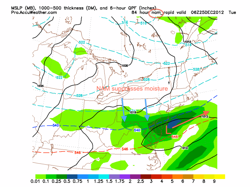
The NAM forecast model suppresses the moisture, which would lower any snow totals significantly.
NAM 2 AM Christmas Day
In terms of snow totals, if the GFS scenario is correct, 3-4 inches of snow will be on the ground by Christmas morning. I know many kids will be ecstatic when they see a few fresh inches of snow Christmas morning. If the NAM is correct, then a general 1-2 inches could fall.
Storm 2: The Nor’easter? December 26th-27th
Storm 2 is a much, much harder forecast. In terms of teleconnections, we are dealing with a positive NAO and a negative AO, usually not the best signs for large big city nor’easter. Nonetheless, the forecast models have been showing a possible major storm next Thursday. There are multiple scenarios that the models are projecting for this storm.
Scenario 1: Nor’easter; Mix to snow in Philadelphia, all snow N&W of the city
This scenario is what the latest GFS run has shown. The storm digs the jet and rides the coast bringing in enough cold air to support heavy snow. The heaviest snow would occur Wednesday night into Thursday morning. From this solution, a general 8-12 inches would be expected for areas north of city. Because we are still a little less than a week out, it is very hard to determine if this is likely or not.
GFS nor’easter 8 PM Dec 26th
Scenario 2: Apps Cutter
Scenario 2 is supported by the European model. This would bring the storm up the Appalachians and push warm air into the Philadelphia region. The form of precipitation with this storm would be mostly rain, with some snow on the backside of the storm. Throughout this past week, this scenario was looking as the more likely solution, but many forecast models have started to back away. Over the next few days, the legitimacy of this scenario will be tested. By Sunday, I should have a better idea for this storm and the path it will take.
It is going to be a busy week for many forecasters across the Northeast; stay with Philaburbia for updates and snow maps for the upcoming storms.
Hey everyone. I hope it has been a relaxing Thanksgiving for many of you. I have been tracking a very pesky low pressure system that will bring some snow and rain to the area tomorrow. The forecast models have not done a good job with this storm, much like the last nor’easter that busted for most of Philadelphia area.
Every run has seen some sort of evolution with this storm. Last week, the prospects for a minor snowstorm seemed likely. But through the weekend, the forecast models started to lean away from the snowy solution, sliding the storm south and out to sea. However, the last few runs of the short range models have been forecasting a more aggressive system tomorrow. The NAM, in particular, has been showing a good 2-4 inches of snow falling just north and west of the city.
I am sitting on the conservative side right now with this storm. It is still November and the ground is still fairly warm from the fall. I do not expect much accumulation on roads. Some sidewalks and driveways could be covered, especially if dynamic cooling occurs and the snow is falling at night.
A wintry mix should start in the mid-morning and continue into the evening. At some point tomorrow, the mix could change to snow. The earlier the changeover, the more snow we receive.
As you can see on the map below, at 4PM, the rain/snow line will be very close to the Philadelphia area. If this line moves south 10 miles, more snow will fall and more accumulation will occur.
NAM snow at 4 PM Tuesday
The European model shows a general 1-2 inches of snow to fall by tomorrow late night:
It has been a very polarizing day for the forecast models today. Last night, after I posted, all the models showed the storm heading out to sea, sparing the area of snow/wind. But, today the models have shifted west and many have been showing a fairly substantial snowstorm for the area. If you read my last post, scenario 1 looks to be the most likely and the one I am predicting.
About the storm:
A piece of energy sitting off the North Carolina coast will phase with a negative trough and form a nor’easter. This nor’easter, from the influence of the trough, will stay close enough to the coast for precipitation to fall with heavy ne winds in our area. Even though surface temperatures will not start out at 32 degrees tomorrow afternoon, dynamic cooling will occur when the snow starts to fall. This is when cold air aloft comes down to the surface and lowers the temperature to near 32 degrees. The snow that falls will be very wet and heavy; large snowflakes.
GFS model 4 PM Wednesday
Timing:
12 PM-2PM: Light rain starts to fall
2 PM-8 PM: Eventual changeover to sleet/snow as dynamic cooling occurs
8 PM-6 AM: Snow and wind
6 AM-12 PM: Snow winding down and may end as some rain
Snow Totals:
I am calling for a general 2-4 inches of snow to fall in the Philly area tomorrow. A few models have shown totals upward near 8-12 inches, but considering the time of year and snow ratio, totals should stay lower than what the models project. In north jersey and Catskills I called for 3-6 inches because of elevation. The shore and NYC should have a mix, which will keep their accumulations near zero. Of course things could change over the next 20 hours or so…so stay tuned.
Repercussions:
Much like the Halloween storm last year, wet heavy snow will fall with some trees still having leaves on their branches. As a result, widespread power outages could occur on Wednesday night/Thursday morning as the snow weighs down these trees and power lines. There will be a few school delays/closings Thursday. Because most roads will be snow free (it has been too warm recently to support much snow to stick on the roads), most schools will make the decision based off of how much damage the snow will cause.
Hey everyone. Just as the area is starting to recover from Sandy, another powerful nor’easter is on its way on Wednesday into Thursday. Originally, I predicted that this storm would be a mainly wind and rain event. There was just not enough projected cold air aloft to support snowfall. But, over the past day or two, the forecast models have been trending toward a more Eastern and stronger scenario. A stronger and further East storm would pull in more cold air, giving us a major snowstorm. Yes, many of you might be thinking, “This cannot be happening. First a hurricane, now snow?” We are in a very brutal pattern right now. Fortunately, after this nor’easter passes on Wednesday, the weather will calm down for a while.
There is so much uncertainty associated with this nor’easter. A shift of 20 miles east or west could change the forecast drastically. As of today, there are three possible scenarios. By tomorrow, I hope to make a final call and prediction for the storm.
Scenario 1: Storm takes benchmark. Heavy wind and snow. (European and UK model solution)
This scenario downright frightens me. Truly. I have seen the destruction from Sandy, and cannot imagine seeing more trees coming down and more power outages occurring. Unfortunately, this scenario is looking more and more likely as we get closer to Wednesday. The European forecast model is currently showing this scenario (note that the European projected Sandy correctly 9-10 days out, so we are dealing with very trustworthy data). The European brings the storm up the benchmark (100 or so miles east of NJ coast) and gives us 3-6 inches of wet, heavy snow. Much like last year’s Halloween snowstorm, this snow will create some major tree damage and widespread power outages. With both scenarios the wind will also be a factor. Our area is already under a High Wind Watch. Gusts will be near 50 mph inland and near 70 mph at the shore.
European at 7 PM Wednesday
Projected snow cover (10:1 ratio) of European (note that likely ratios will be more around 5:1, so just divide the totals by 2):
European Snow Forecast
Scenario 2: Out to sea; light snow
This scenario has been projected by the GFS and NAM model. It shows the storm phasing with the trough a tiny bit later than the European model. With this scenario, we would have a period of light snow and some high winds before the storm pulls away. Because the storm would be further away from the area, its effects will be lessened quite a bit.
Here is the GFS model showing this Eastern track:
GFS model Out to Sea
Scenario 3: Storm hugs the coast: Heavy rain and wind
As of right now, no forecast model is showing this solution. A few days ago, many were in consensus for a “coastal hugger” that would give Central PA and NY snow and our area heavy rain and wind. As of today, this scenario is unlikely, but still possible.
My thoughts:
It has been truly challenging to forecast this storm. Do not listen to news outlets. For a storm like this, every model run matters. Many times, news stations do not put up the most recent or accurate forecast. Luckily for you all, the maps I am posting are 2-3 hours old… aka “fresh off the press.” 🙂
My Preliminary Prediction:
I do not like to predict snow this early in the season, but as we saw last year, anything is possible. Right now I am leaning toward the European solution, as it has been the most reliable historically. Once again, I would start preparing as soon as you can for this storm. Make sure you have the necessities to last a few days in case of a power outage. Remember, it’s much better to be safe than sorry.
It really has been an unfortunate week for millions of people along the East coast. Sandy caused over 100 billion dollars in damage and 98 deaths in the United States. Millions of people still remain without power and the Jersey shore has become uninhabitable in many places. It really is sad that weather can cause so much destruction and sorrow. I want to ensure people to keep their heads high. With all the support coming in from government and charity organizations, the Northeast will soon be back to the way it was pre-Sandy.
Now, to the weather:
I hate to be the bearer of bad news, especially when it comes to the weather. Unfortunately, we have another coastal storm coming next Wednesday. Luckily, this system will not be nearly as strong as Sandy. Like Sandy, it will primarily be a rain and wind maker. Even with the lack of cold air aloft and at the surface, the far NW suburbs could see some snow out of this system. Rainfall totals could reach 2 or 3 inches by the time the storm pulls away. Winds could also gust to 30 or 40 mph, especially along the coast.
European Wed 8 PM
I will post additional entries if there is a change in the storm’s track or precip type as we head into next week.
Hurricane Sandy has intensified overnight. Her minimum central pressure is now 943 mb. This will break many low pressure records in NJ and other mid-atlantic states. Maximum sustained winds are 90 mph with gusts to 115 mph. I am truly concerned for the Philadelphia region as we head into tonight. I cannot imagine 90 mph winds from Sandy’s eyewall hitting the region. She is expected to make landfall at around 9-10 PM tonight near Atlantic City. So far, not too many power outages have been reported. This will likely change as the winds increase today and tonight. Check back for more updates today and tonight. Stay safe.
9 PM update:
According to the National Hurricane Center, Hurricane Sandy is located 280 miles east-southeast of Cape Hatteras and 485 miles south-southeast of New York City. Maximum sustained winds are currently 75 mph with gusts to 90 mph. Minimum central pressure is 950 mb, which normally signifies a category 2 strength storm. Sandy’s hurricane force winds extend out to 175 miles from the center. Tropical force winds extend out to 580 miles from the center.
Sandy is expected to continue northeast before taking a turn west toward the Jersey coast. Major storm surge will flood many coastal areas including NYC. Mandatory evacuations are active for the entire NJ coastline. This storm is not like Irene last year. Sandy is coming inland with a much larger wind radius. Stay safe and smart.