Stormy Weather Tomorrow Night… Big Rainstorm Storm on Sunday


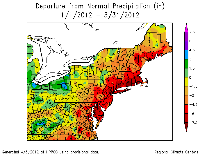
Hi everyone. The quiet weather we’ve been having for the past month and a half will come to an end this weekend. Our drought, as well, will be coming to an end after this weekend.

There are two parts to this storm:

Part 1: Squall Line Saturday Night

A squall line associated with a cold front will barrel through the area Saturday night. Storms could be strong to severe with this line as it passes through. Here is a picture of the simulated radar of the squall Saturday night:

WFF simulated radar 11 PM Saturday

Part 2: The nor’easter.

After the squall line moves through, it will phase with a low pressure system moving north. A large and strong nor’easter will form and move northeast, then west into New England Sunday night. This storm will be a major rain maker, and snow could even fall in interior New England and Western PA. Around 3-4 inches of rain will fall by Monday evening. There has been some debate how strong this storm will actually get. If the cold front phases with the storm, it will be strong. If the phasing is weak, then the storm will be weaker. The amount of rain we receive will be based off of the strength and exact path of this storm.

Large Rainstorm 11 PM Sunday

Philaburbia is Back: Cool-down Mid-Week; More About our Impending Drought


Hey everyone, sorry for the “drought” of posts the last two weeks. It has been hectic lately for me.

So, the last few weeks have been seasonable, dry, and sunny. Our pattern since early March has been dominating the country. The Bermuda high from mid-March is gone, but the dry weather continues. A strong high has cemented itself in the midwest, but will slowly move east over the next two weeks. By next week, the high will be in the Atlantic and warmer weather (70s) will return. After that, it is looking that a few rainy days are likely into late April.

This week, look for a bit of a cooldown and a slightchance of showers. A weak low pressure disturbance will spin in the Atlantic and bring us some windy conditions, an isolated shower, and partly to mostly cloudy skies until Thursday. Highs will be in the 50s before going back to the 60s midweek.

More about the possible drought:

Impending Drought

Because of the lack of precipitation over the last four months, a drought could be coming for the summer. In my opinion, I do not think this drought will last. We are headed into a weak El Niño, and historically, we have had wetter than average summers during these years. Currently, there is a major threat for wild fires. Red flag warnings will continue to be issued by the National Weather Service.

Heading into Weak La Niña by June

Continued Warmth this Week; Cooldown Possible for Early April


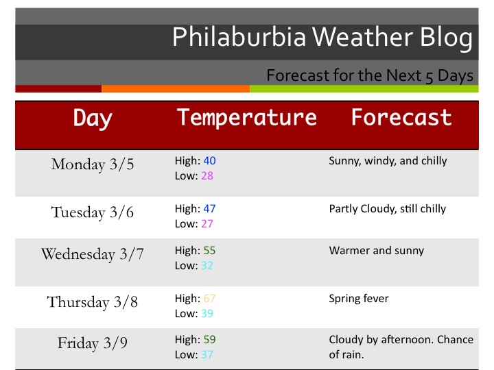
Wow, what a stretch of nice weather we have been having! As I sit here on my patio with an iced tea and a computer on my lap, I cannot seem to remember such a stretch of nice weather in March. Temperatures have been in the 70s and 60s consistently for the past 2-3 weeks and will continue for another 1-2 as a May-like airmass dominates most of the country. The pattern has really slowed down and systems are riding the jet way north. Our next chance of any precipitation will be next Saturday. Until then, enjoy the weather!

5 Day Forecast

Long Range Insight:

So, what else is there to say? Monday will be beautiful, so will Tuesday, Wednesday, Thursday, Friday, and even next Saturday morning. Amazing. Of course, things can’t stay like this forever. Like any weather geek, I have been looking for signs when this pattern will change. It seems, according to the long-range models, that early April will have a fairly significant cooldown. I could definitely see high temperatures in the 40s and lows in the 20s for a few days in April as the arctic air tries to make one last push South.


Very Warm for the Rest of the Week; 60s Next Week as Well


Welcome to May… in March. Temperatures are soaring into the 70s today and will reach the mid 70s by tomorrow. Next week will be warm as well, with a few more precipitation chances. Tonight, a small warm front will push through the area, while a Bermuda high will setup behind it. There will be a few showers tonight, with a chance of some rain in the morning tomorrow as well. Things should clear out before Tuesday afternoon.

Forecast

The rest of the workweek looks nice before a weak disturbance sweeps past the area on Friday/Saturday. Temperatures will stay warm next weekend into next week. Our jet stream is starting to move north and soon enough, our severe weather season will start.

About our winter:

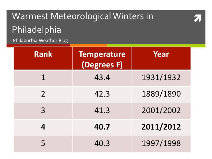
The Meteorological winter ended March 1st, and the National Weather Service official announced that this winter was the 4th warmest winter on record. My explanation for this is the prominent La Niña, as well as a very positive NAO (no blocking).

Warmest Winters on Record


Cold Start to Week; 70s by Thursday? Warm into Late March


Meteorological winter has ended, as well as ours. Spring is into full swing this week.

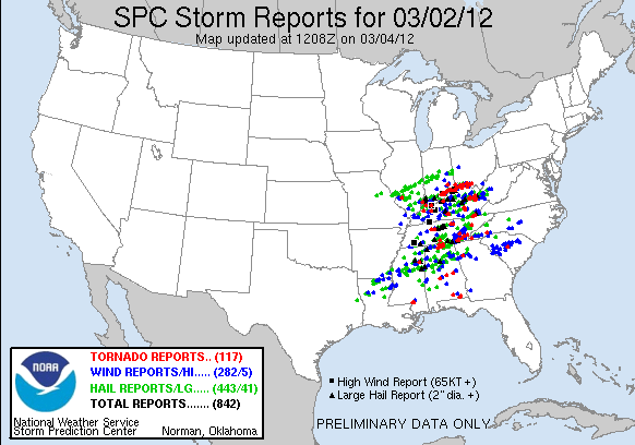
The first issue I want to comment on is the tornado outbreak on March 2nd.  Over 30 deaths were reported from these superstorms. The amount of rotation recorded in these cells was astounding, and tornadoes were coming down left and right. 117 tornadoes were reported. More outbreaks are likely in March and April, as our pattern slowly shifts to a summer one.

Our weather:

A clipper will pass to our south on Tuesday, giving Virginia a few more inches. Then high pressure will set up to our East and will warm temperatures up significantly on Thursday and Friday. I would not rule out 70 degrees in some areas on Thursday. By next weekend, a cold front will cool us down, before another ridge moves in and sends temperatures back into the 60s.

Forecast 3/4

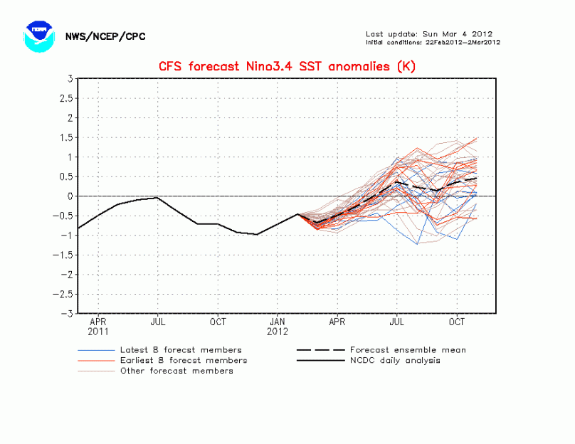
Lastly, I wanted to talk about the upcoming El Niño for the summer. Right now it is looking like we will have a weak El Niño or neutral El Niño/La Niña. This uncertainty will be extremely important for any hurricane season predictions. Let me explain:

Weak El Niño years have fairly calm hurricane seasons. 2009 was a great example of a weak El Niño. Only 10 named storms formed that year. Other El Niño years include 1997 (7 named storms), 2002 (12 named storms), and 2006 (20 named storms). If a weak El Niño exists this summer, we will likely see around 10-12 named storms with 1-2 of them affecting the mainland USA.

Neutral years, on the other hand, have extremely active hurricane seasons. If a neutral pattern exists during this hurricane season, the number of hurricanes will likely be similar to the 2001 and 2002 hurricane seasons. Those years, there were 15 and 12 named storms respectively. For each year, there was a weak La Niña transitioning to neutral, just like this year.

Many Meteorologists will be watching to see what the La Niña does as we head into summer. In my opinion, 12-14 storms is the good preliminary number based of off the La Niña 3.4 SST anomaly graph (negative #s are La Niña, positives are El Niño):

Fun Fact Friday: Largest Hailstone Recorded


I know it’s a breezy and chilly Saturday afternoon, but I figured I would do my fun fact friday post anyway.

The largest hailstone ever recorded fell in Nebraska in June 2003. The size of the hailstone was 7 inches and was as large as a regulation soccer ball! Hailstones are formed by intense updraft accompanied by freezing temperatures in severe thunderstorm clouds. The stronger the updraft, the larger the hailstone.

Largest Hailstone

Reaching the 60s This Week Before Large Storm Friday/Saturday


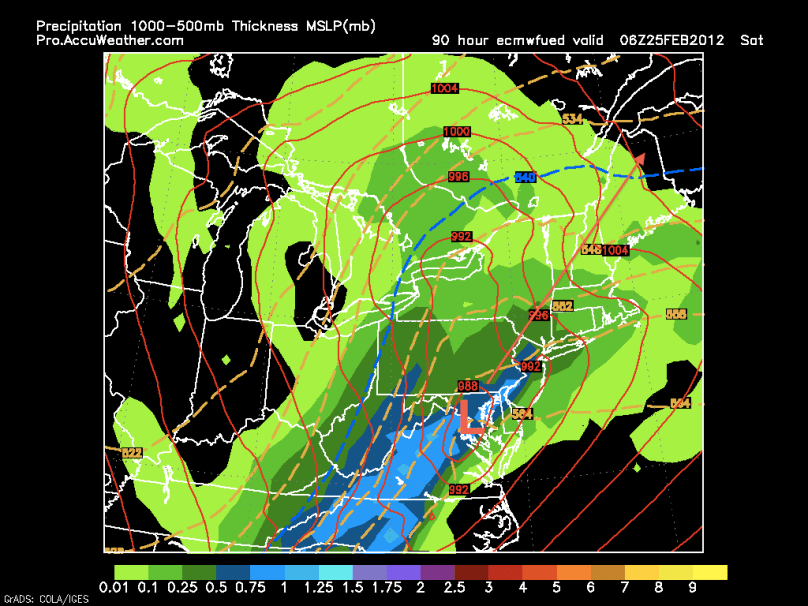
Temperatures will climb into the 60s for the rest of the week as a Bermuda high (normally seen in the summer months) sets up to our southeast. Wednesday should be the nicest of the week with sunny skies and temperatures in the 60s. On Thursday, a string of weak disturbances will move through, making for damp, dreary, and warm conditions. By Friday night, we are looking at a potential large storm coming just west of the area. This westerly track means we will be on the “warm side” of the storm, and our precipitation will be in the form of rain. After this storm moves through, windy and cooler conditions will take over for the weekend.

Here is the European model at 1 AM Saturday showing heavy rain and warm temperatures:

European Model

Next week will be fairly quiet until later in the week and weekend. A storm system has the potential to affect the area either Thursday, Friday, or Saturday next week. Details about this storm are vague, but it could have the potential to bring in enough cold air to support snow. Once again, because the NAO and AO are still positive,  it will be tough for a storm to wrap up and ride the coast. My gut feeling is that the storm will suppress to our south, much like the one this past weekend.

No More Sunday Storm; Another Warm Week Ahead


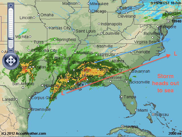
Well, it looks like the storm tomorrow is going to be suppressed to the south. As I said on my last post, the teleconnections just do not support a major storm, and the jets just will not phase in time to turn the storm northward. Right now, the system is wrecking havoc on the south with severe storms and heavy rain. It will continue its eastward track and drop some substantial snow fall in Virginia.

Storm heading out to sea

The week ahead will be another quiet one, with temperatures going back into the 50s and high 40s. Winter is starting to transition into an early spring. Our chances for a snowstorm will continue to diminish as the jet stream shifts and the sun angle increases.


Our next chance for some precipitation will be next Friday.

Until then,

Jason

Rainy End of the Week; Upcoming storm this Sunday with Snow Potential


Warmer temperatures will dominate the rest of the week as a high pressure system will setup just to our southeast. Temperatures will reach the high 40s tomorrow and into the 50s on Friday. A weak cold front will pass on Friday as well, giving us a soggy and dreary end of the week. However, all of my attention right now is focused on the possible big storm on Sunday.

After the cold front pulls through, moisture part of the southern jet will start to organize in the Gulf of Mexico. Another weaker low will form in the midwest, part of the northern jet. These two disturbances have a potential to phase and undergo cyclogenesis, intensifying rapidly. There is no doubt that a strong storm is coming. There is doubt about where the phasing will occur and when the storm will intensify. Many models are showing different solutions right now and every run varies. As a result, I will introduce two scenarios:

Scenario 1: Out to sea. Ah, our friendly “out to sea” solution. I have to say, I am leaning toward this solution. The teleconnections are fairly unfavorable for any quick phasing and blocking, and there just does not seem neutral/negative tilt to the trough. In this scenario, the storm will suppress to the south and not even phase with the northern jet. No precipitation would be expected and temperatures would be seasonable for this time of year. Right now, the European model is showing this solution. Here is the European at 114 hours out (1 AM Monday):

European model (courtesy of Accuweather)

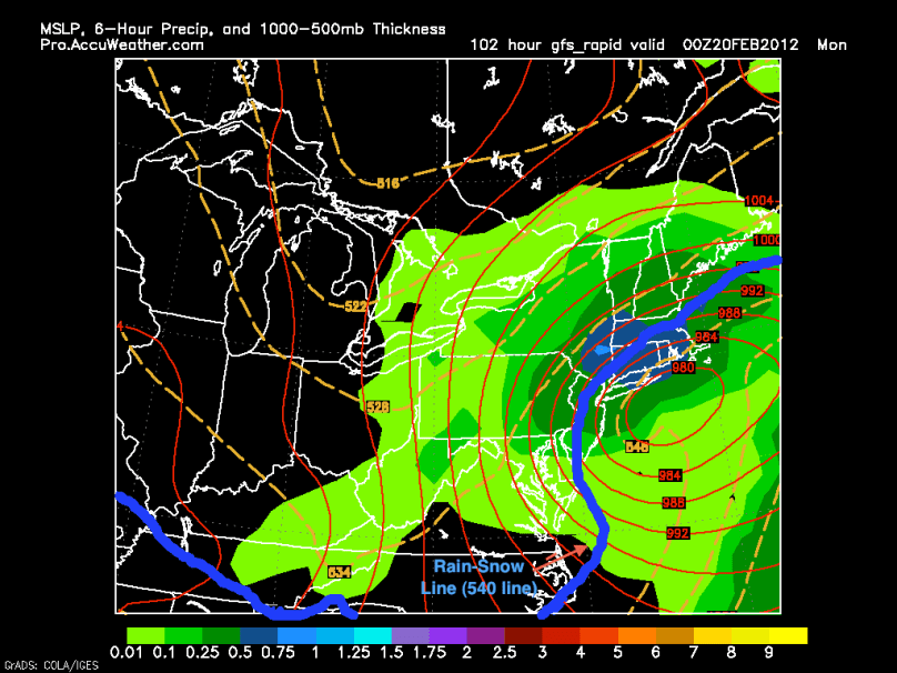
Scenario 2: Storm along the coast. This scenario represents the classic nor’easter. The jets will phase and the storm will rapidly strengthen, bring in its own cold air, and ride the coast. Right now, this scenario has one inherited problem: there just is not enough cold air initially to bring us a 100% snowstorm. Because it seems like the jet will be flat and our temperatures will be in the 40s, it will be tough for our area to receive all snow from this scenario. However, I do like the setup of the storm and if it can wrap around enough cold air…look out snowlovers! The GFS model currently is showing this scenario:

GFS Solution

Over the next few days, the forecast models should reach a more promising consensus. I will continue to post any updates about this storm.

-Jason

Another Nuisance Snowstorm Tomorrow Morning, Followed by Brutal Cold


Yet another nuisance snowstorm will affect the area early Saturday into the afternoon. This system is a bit more expansive than the one that hit on Wednesday. Moisture is being brought up from the gulf, and the storm has the strength to bring in its own cold air. The models have been fairly consistant about this storm and it is looking like 1-3 inches around Philadelphia with 2-4 inches further north. New York City could even see 3-6 inches as the storm strengthens over the Atlantic.

NAM Model 7 AM Saturday

Roads will be slippery tomorrow morning, but they should be mostly wet by the afternoon. Following the storm, extremely cold air will be coming in. It will be windy and freezing on Sunday, as well as Monday. Our next chance of snow will likely be Wednesday, probably only a coating.

Till next time – Jason