Latest on the Storm


Update: 11:30 PM:

Snow is really starting to band throughout the area and we are seeing isolated 2-3 inch per hour rates. The snow should start to slow down by 4 AM and be totally out of the area by 8 AM. I will have pictures tomorrow morning as I have a day off from school!

Well, parts of the area are already seeing some light snow as the low pressure in the Ohio Valley moves to the east. There have been some changes to the timeframe and totals a little bit. The snow will start a little earlier than I though and probably end a little earlier as well. Also the low in the Ohio Valley has turned out to be a bit stronger, which means that the phase between the coastal low and the Ohio low won’t happen until the storm is practically over New England. This means slightly lower totals for the southern part of the area (Chester, Delaware, Philadelphia). Totals should keep the same in the northeastern areas (Bucks, Mercer, Hunterdon) as these areas will be closer to where the storm phases.

Here are some specific snow total predictions:

1. The City of Chester, Delaware Co.: 3 inches

2. Philadelphia: 4-6 inches

3. Hatboro, Bucks Co. 5-7 inches

4. Trenton, Mercer Co. 8-11 inches

As you can see the totals will go up the more northeast you go.

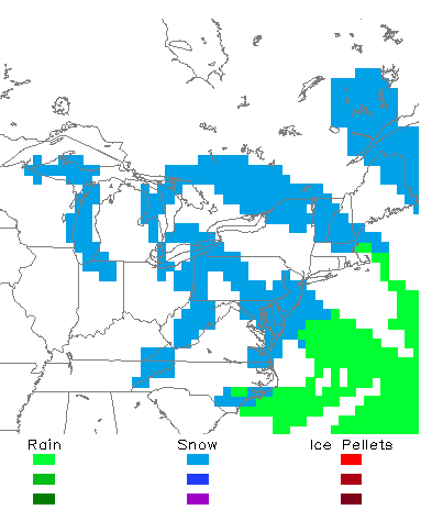
Here is a live radar image of the storm to keep track as the night progresses:


Storm radar

I will have updates as the night progresses….

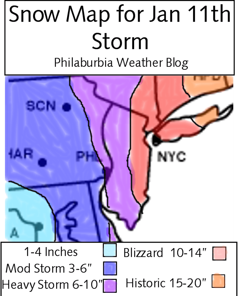
Snow Map for Tuesday Jan 11th Snowstorm


Hi everyone. I finally have a snow-map set up and ready. This storm will be a New England special with most of the 1 to 2 feet totals happening in Massachusetts and Connecticut. For this area we are looking at a fairly substantial snowstorm with a potential to put down 6-12 inches of snow in one night. My snow map is mostly based off of the NAM computer model released by noaa, but has shades of other model predictions as well. I believe that the battle zone for this storm will be anywhere east of Doylestown to Bordentown area. Every storm ends up doing something unexpected in the end, and right now with the complexity of the timing of the storm and when it will phase makes a surprise very possible tomorrow night.

Timing: The storm should start by 11 PM and wrap up by 11 AMish. The snow will be heaviest during the 3-6 AM time period.

With that said, here is my snow map. I believe my totals are the best estimate of how much will fall tomorrow in the area. If any changes ensue over the next day, I will try and make revisions to the map.

Jan 11th Snowstorm

School Closings:

As far as school closings are concerned. I believe any school north of Philadelphia will be closed Wednesday. With the amount of snow that is going to pile by the late morning, I just don’t believe the salt trucks will be able to clear the roads in time. The morning commute Wednesday will be treacherous, so anyone going to work Wednesday, drive slowly and carefully.

Snowstorm Coming Tuesday Night/Wednesday Morning: Snow Map Tomorrow


Only a few words today cause I’ve been really busy (thanks AP gov). We have a major snowstorm coming I am 100% sure of it. The totals right now are still up in the air but I’d say 6+ inches will fall Tuesday Night into Wednesday. Winter Storm Warnings will be issued tomorrow night and schools will be closed Wednesday and possibly Thursday if we get over a foot of snow. I will post a snow map tomorrow with complete total predictions.

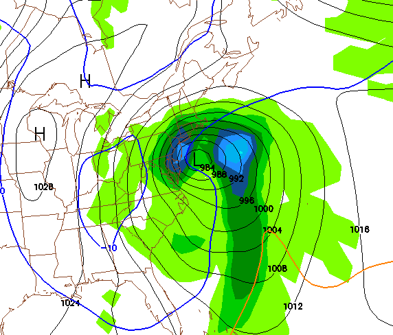
Until then, get ready for another major snowstorm because I guarantee it will look like this on Tuesday Night:


Wait! More Snow on Saturday? Is This Possible?


I was introduced to a pleasant surprise this afternoon when I found out ANOTHER winter weather advisory was issued for the area. The computer models have placed a last-minute low pressure forming in North Carolina tonight and moving up the coast tomorrow. This means that ANOTHER 2-4 inches of snow will fall in the area Saturday which will cause MORE travel problems and more snow on the ground. THEN, we have the big storm probably coming Tuesday Night into Wednesday which will give us the more significant snow amounts. The next week will be one of the busiest of the season so far, and by Thursday we could have over a foot of snow on the ground.

Snow Projection for Saturday Jan 8th


Snow Saturday Jan 8th


Friday Storm Looking Like a Nuisance; Storm Next Week Looks Good


Hi everyone, I am doing a tiresome late night post about the upcoming Friday storm and the more favorable storm next Wednesday.

Friday Storm: This Friday, a clipper system will move west through the area and eventually phase with a low pressure out to sea. The models haven’t been handling this storm as well as the Post-Christmas storm. Everything has to fit like a jigsaw puzzle for this coastal storm to form: the clipper has to be in the right place at the right time, as well as the low in the Atlantic. From the latest model consensus, I would say a good 2-4 inches of snow will fall on average throughout the area. The northern areas will most likely get more than the southern because at this point, the coastal is expected to form near Cape Cod. I would also expect a Winter Weather Advisory to be posted either tonight or tomorrow.

Travel problems for the Friday storm: There will undoubtedly be traffic problems during the day Friday as the clipper moves through and strengthens in the afternoon. I do not believe any schools will let out early, but if any increase in snow intensity is shown on the models, some schools could let out early.

About the January 12th storm: I am really liking the looks of this storm. Even though some of the computer models have been showing an out to sea scenario, I believe that the setup is perfect for a major snowstorm. I am talking about this early just to give everyone a heads up and to beat the local TV news stations of its coverage. The GFS has been showing a major snowstorm and the EURO has been going back and forth. I would say the best chance for any schools being closed this season will be for the storm next Wednesday. Even though this is a bold statement, I really feel that the setup is perfect for a Nor Easter next week. I will be posting more about this storm as more details are ironed out.

Sorry guys, no pictures today, I’ve been very busy with school and the works. Tomorrow if I have time, I’ll post a snow map of Friday’s storm and more details of next Wednesday’s Nor Easter.

Overview of the Post-Christmas Blizzard of 2010


Hi everyone! I just want to say thanks to everyone for visiting the blog yesterday, Philaburbia needs all the support it can get. The blizzard has finally pulled out of the area bringing in sunny skies and nasty frigid winds from the northeast. This storm was a little different from the classic Nor Easter. Because there wasn’t a blocking high to the north, more banding occurred with the snow making the totals a little inconsistent in some areas. I would say my forecast, if you take the average snow amounts from each area, is fairly accurate. The storm did go further east than previously thought, which took any mix potential out of the question along the coastline, but overall the totals for the area (not counting the shore) were in the 10-20 inch range.

Here is a radar loop until midnight last night of the storm for your viewing pleasure:

Radar Loop

And now for the snow total recap. At my house I got around 9.5 inches of snow with some higher snow drifts. Snow totals were much higher to the east in NJ and lower to the north and west.

Toms River NJ: 28.0 inches

Princeton NJ: 15.0 inches

Philadelphia PA: 12.4 inches

Doylestown PA: 5.1 inches

Somerset NJ: 22.0 inches

These are just a few of many reported snow totals throughout the area. This storm will definitely be remembered for anyone living in NJ for many years to come. As for Southeast Pennsylvania, I have a feeling that there could be a storm for Monday January 10th (yes I know that’s 14 days away) which could give anyone living north of Philadelphia their blizzard.

Anyway, thanks for keeping with Philaburbia Weather and keep checking back throughout the winter for any snowstorm possibilities!


Updates for Post-Christmas Blizzard


Update 8:00 PM:

Well the snow has finally  reached its peak in many places in the area. It is true that totals won’t be as high for the area as the low pressure system went more east than expected. There hasn’t been an update for the snow totals since 4:30, so I won’t start listing those until after the storm. I did go outside my house and gathered an average of measurements.These averages ended up being around 5.5 inches, which is a pretty substantial amount considering that this storm isn’t close to being finished.

Here is the current radar view. The Nor Easter should continue bringing moisture in as it stalls south of long island and eventually starts to move northeastward.

Current Radar as of 8:00 PM

Update 3:00 PM:

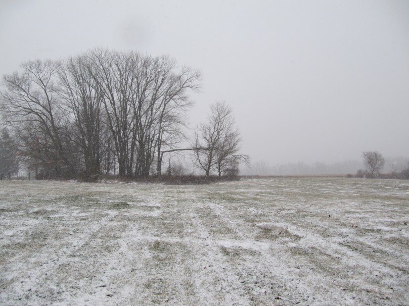
Snow is really starting to pick up here with visibility levels dropping to 1/4 of a mile in places. At my house moderate to heavy snow is falling and I would say a good 2 inches are on the ground as of 3:00 PM. I took a few pictures when I went outside around 40 minutes ago. Since then visibility has dropped and the snow has gotten much heavier. This snow rate should continue over the whole area for the rest of the day into tonight, where the low pressure will stall south of long island and really intensify. The snow should start winding down tomorrow morning and sunny skies should prevail by Monday afternoon. There is still a Winter Storm Warning until 1:00 PM tomorrow.

Anyway, here are the pictures:

View of my Backyard
View of my Street
Another View of the Snow

Update 12:00 PM:

Light snow has started to fall at my house in Bucks County. Snow has started in much of the area and will continue to intensify as the low pressure m0ves northward and strengthens. Over the next few hours, expect 1-2 inches of snow on the ground as conditions rapidly deteriorate.

Right now the heavier snow bands are moving northwestward and will eventually encompass the whole area:

Radar Analysis

Update 9:00 AM:

Hi everyone, the blizzard is currently sitting just south of the Outer Banks and strengthening rapidly. The storm is currently taking a turn to the north which will gradually bring the precipitation up from the south. Snow will start out fairly light later this morning, but will pick up in intensity by this afternoon and evening. During this time, snow rates of 1-2 inches per hour are possible. The snow will wind up by Monday morning leaving a crippling snowstorm in the area.

You can follow the storm on the Radars Page or just keep track with the radar posted below. I will hopefully have some pictures as the day progresses:

Blizzard Radar

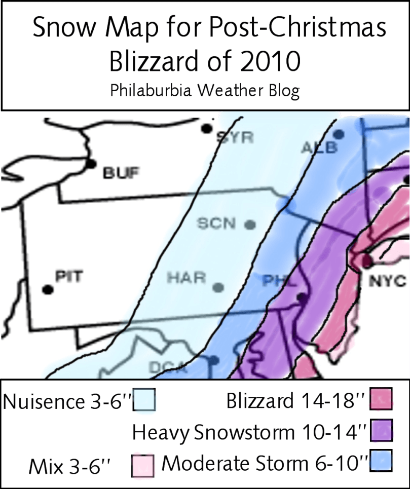
Snow Map for Post-Christmas Blizzard of 2010


I have finally come to a conclusion for this snowstorm. Many of the computer models are finally on board with the GFS solution and are showing major snows for the whole Mid-Atlantic and New England region. We are already under a Winter Storm Watch, which was issued by the National Weather Service overnight. In my snow map below, I have put most of the Philaburbia Coverage Area under the 10-14 inch range. If you look at the map, you will see a sharp cutoff in the snow amounts. This is the only thing concerning me right now. If the low pressure doesn’t pick up the trough and ride the jet stream, it will go maybe 100 miles east of the benchmark which would give us much less snow.

But, as of right now, I am expecting one of the most brutal Nor Easters (competing with last years storms) of all time. Winds will range from 30-50 mph during the height of the storm (Sunday Night). And we will probably see a Winter Storm Warning followed by a shorter range Blizzard Warning during the evening on Sunday. Do not travel on the roads or in the sky from Sunday Afternoon to Monday Evening. Conditions will be on the deadly scale for anyone stranded on a deserted road.

I am also concerned for the EaglesVikings game tomorrow night. Anyone that is going to that game, be wary that you will be driving in blizzard conditions and sitting outside in blizzard conditions . It’ll be fun to watch on TV, but not as fun for the people going to the game.

Snow Map for Post-Christmas Blizzard of 2010

I will come out with the time frame of this storm as the details become more available. Otherwise, haul your shovels out and prepare for a nasty storm.

Update for Post-Christmas Storm: Good News for Snow Lovers!


Well, this storm has really been quite challenging for many weather forecasters and enthusiasts alike. The weather models have been all over the map for this storm, switching from an out to sea scenario to a big coastal storm. I have great news for snow lovers (like myself). The GFS model, which many forecasters rely on for their predictions has been showing a large scale snowstorm for our area. Three straight runs have shown at least a foot of snow for most of the I-95 corridor.

As of right now however, the GFS is the only model that is showing this solution. I am still uncertain about the track of this storm and how much snow we are going to get. Therefore I will not make a snow map until most of the models are in some sort of agreement with each other.

Here is the blizzard scenario from the GFS:

GFS 0z Major Blizzard for Major Cities

Preliminary Snow Map for the After Christmas Storm


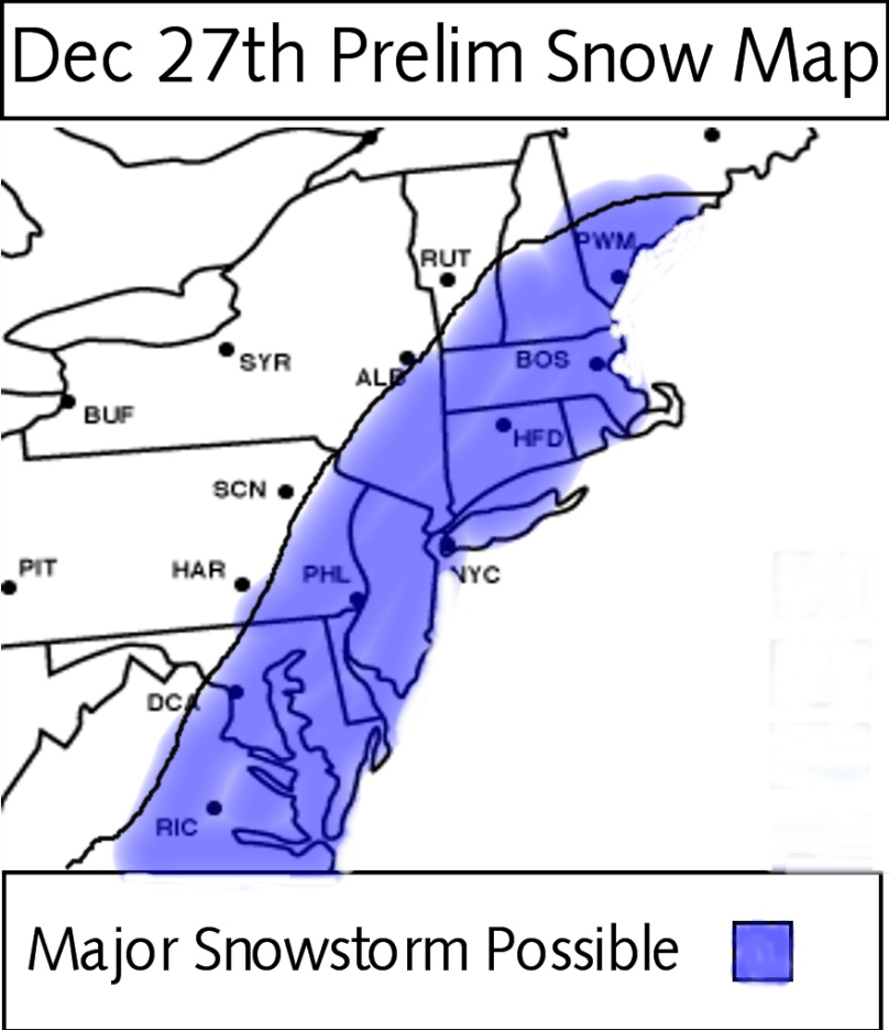
It is looking right now that a major blizzard is coming to the area for December 27th. We will not be having a white Christmas, but, may have a white New Years. Since my last post, there hasn’t been much change with the model consensus. The European Model continues to show a major blizzard and has been showing one for the past 3-4 days now.

The most recent run of the GFS model shows the storm just grazing our area with 3-6 inches of snow. It’s a better solution than what the GFS had in previous runs, but still no blizzard.

Most of the other models have the storm in between the European and the GFS. Personally, I think the European is the right solution. It is known as the most accurate model in the world, and has been showing a blizzard for the Eastern seaboard for a long time. Also the NAO is going to tank, which means a snowstorm is more likely than not.

I have decided to make a very preliminary map for this storm. It outlines the places where a major snowstorm is possible. I don’t want to come to conclusions at this point because the consensus between the models is still very poor. Once the GFS and Euro are on the same page about things, I’ll post a more detailed map with actual snow totals.

Preliminary Map for 12/27 Snowstorm

Adios till next time