Start to Prepare Now for Hurricane Sandy (Frankenstorm); Lots of Rain and Wind Coming


Let the chaos begin. Hurricane Sandy, now known as “Frankenstorm,” is currently located just north of the Bahamas moving North at 7 mph. It should start to turn toward the NE in a few hours, however It’s central pressure is 971 mb and maximum sustained winds are 75 mph. Sandy is expected to strengthen as she heads out of the “shearzone”. Everything in this scenario points to a “perfect storm.” We have a negative NAO, a hurricane, energy from a trough in the midwest, and a cold front… all phasing together into one huge storm. Here is a satellite image of Sandy (not live image, that will come later):

Animated Image of Sandy (not Live)

Part 1: Track

Most models are in consensus that Sandy will retrograde into the East Coast. Right now the uncertainty lies in where she will make landfall. At this point, it could be as far north as Long Island, or as far south as Ocean City, MD. Sandy, even though a weak hurricane is expected to rebuild and strengthen into a strong category 1 storm. She is also expected to become extratropical as she heads into cooler waters off the mid-atlantic coast.
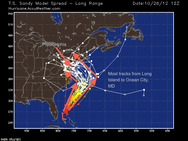
Sandy Model Tracks

Part 2 Model Analysis:

First, the GFS. The GFS has been consistently the northern outlier. A few days ago when I posted, I said that the GFS was showing an out to sea solution. But now, however, it has switched to an east coast hit. The 12z GFS shows hurricane Sandy taking the turn west a little later than the European. This would take Sandy into Long Island. The GFS then brings Sandy south over land, and eventually takes it out over New York state, where it fizzles out. This solution is the outlier out of all the forecast models. I will continue to track the upcoming runs of the GFS, especially as we get closer to the event.

GFS 8 AM Tuesday

The European model takes more of a south track, turning Sandy to the west much sooner than the GFS. This solution would be devastating to the Philadelphia region, as the proximity to the center and heavy rain will bring many trees down and knock out power for days in places.
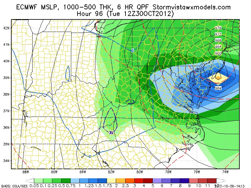
European Model 8 AM

Part 3: Timing and Strength:

Rain will start to fall on Sunday evening as we will get some interaction from the phasing cold front and Sandy out in the Atlantic. Monday should be a dreary day with drizzle as Sandy heads NE before the retrograde. By Monday late night, the rain should start picking up in intensity. By Tuesday morning into afternoon, the heaviest rain will affect the area.By Wednesday morning, things should start to calm down as Sandy weakens and heads north.

Here is the unofficial, arbitrary timeline forecast:

Sunday 5 PM – Monday 7 PM: Cloudy and Drizzly

Monday 7 PM- Tuesday 4 AM: Drizzle becoming moderate rain; some gusty winds

Tuesday 4 AM – Tuesday 5 PM: Heavy rain, heavy winds

Tuesday 5 PM – Wednesday: Rain calming down, Sandy moves out

The wind associated with Sandy will depend on the track she takes. The strongest wind field is expected to be southwest of her center. A track that projects Sandy making landfall on the NJ coastline could bring 80 mph wind gusts with 50 mph sustained at the surface. A more northerly track  (Long Island) will also bring strong winds. A southerly track , however, will bring lesser wind gusts.

Here is the European wind forecast. It is showing around 75-80 mph over Philadelphia 8 AM on Tuesday:
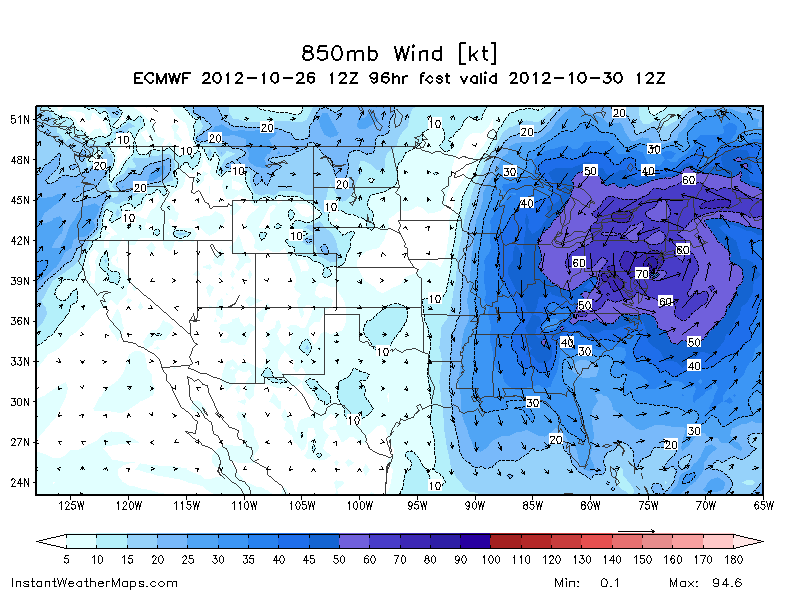
European wind forecast

The rain forecast for this storm is pretty spectacular. Some models have been projecting 6-10 inches of rain falling in the Philadelphia region. I would not be surprised if some areas surpass this prediction.
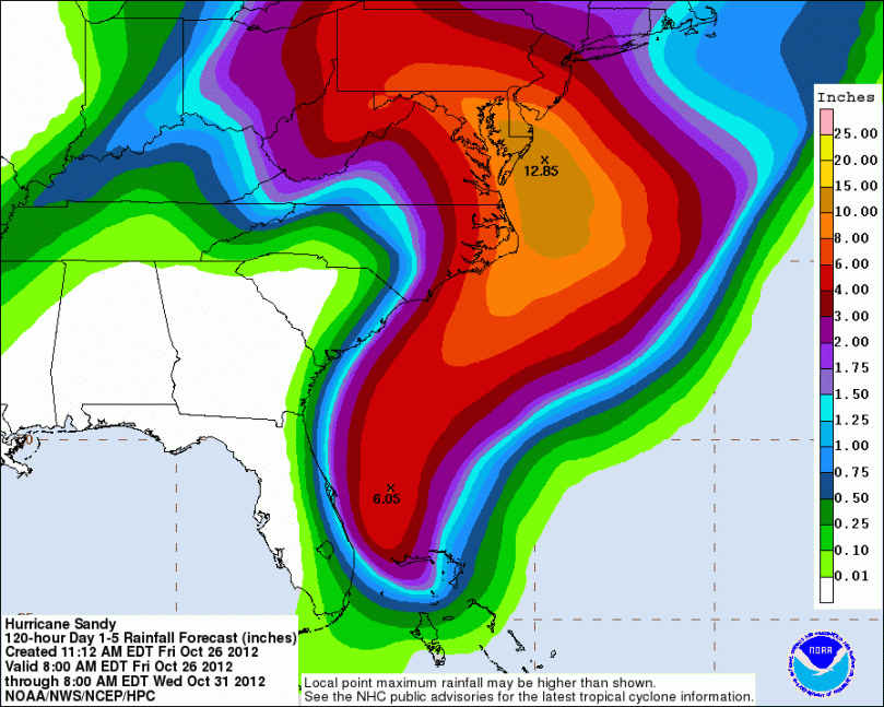
National Hurricane Center’s rainfall map

Part 4: Effects

The effects of this storm will mostly be flooding and wind damage. Because there are many leaves on the ground, many water drainage grates will be blocked, causing widespread flooding. Many tree branches will also snap from the high wind. Some whole trees may even topple. Like Irene last year, there will be widespread power outages. Millions and millions of people will lose power at some point during this storm. Some households may not get it back for days or even a week.

Please start preparing now for this storm. Bring any furniture that has the risk of blowing away inside. Stock up on food and drinks; power outages will last for days in places. If you have a generator, make sure it is working correctly. Try not to drive during the storm as branches will be down on many roads.

Possibly Historic Storm Next Tuesday


Hi everyone. I am officially going into storm mode on the site. This means I will be updating at least daily on the status of this very large storm coming next Tuesday. This past week I have been tracking a tropical system (now TS Sandy) that has the potential to ride up the Eastern Seaboard and retrograde west into the mid-atlantic, causing widespread damage. Even though we are a week out, there has been an unusual consensus with the forecast models up to this point, which is concerning. Like always, there are two possible scenarios.

Scenario 1: Hurricane Sandy retrogrades west into mid-atlantic


Most of the models (European, nogaps, canadian, japanese, and UK) have been showing Sandy strengthening into a  hurricane, phasing with the approaching cold front, and retrograding westward into the trough. This retrograde would have devestating effects on the Northeast region. The models are also projecting Sandy having a minimum central pressure of 940 mb, equivalent to a category 3 storm.

European Model Hurricane Sandy

When Sandy starts to curve back west, she will also bring in cold air from the northwest. Because of her projected strength, this would cause much of the rain to turn to snow in some areas. Accumulations could measure in feet in some places as the cold air is rushed in aloft. The storm, of course would also bring heavy rain and near hurricane force winds (much like Irene last year). Rain measurements from a few of the models have measured near 10 inches in places. Obviously, this is just a scenario that the forecast models have been projecting. It may or may not come true. But because it is possible, we have to make the necessary precautions.

Here is the snowfall map (in inches) for the storm:

Snow Forecast European Model (inches)

Scenario 2: Out to Sea

As of right now, only one forecast model is showing the out to sea scenario: the GFS. The GFS model is known to be the second most reliable after the European (scenario 1 model), For this scenario, Sandy would strengthen into a sizable hurricane, but she would  never phase with the front or trough. As a result, she would turn out to sea, giving us minimum effects. See the map below for scenario 2:

GFS scenario 2

Here is a larger scale map showing both scenarios:

Either way the storm goes, anyone up and down the eastern seaboard needs to start thinking about preparations for this storm. It’s better to be prepared, even if the storm heads out to sea. Preparations include: making sure you have batteries, food, flashlights etc. As we head closer to next Tuesday, tying down/bringing in any outdoor furniture would be a good idea as well.

Freezing Temperatures Tomorrow Night


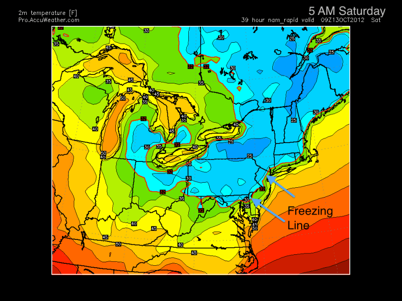
Yes, we continue to progress to winter. The National Weather Service has posted a Freeze Watch for tomorrow night. The watch includes all counties north and west of Philadelphia. High temperatures on Friday will reach the mid-60s. A clear night sky will induce radiational cooling, dropping low temperatures at or below 32 degrees early Saturday morning.

Here is the NAM model. This shows 2m temperatures (6 feet above surface) of the Northeast at 5 AM Saturday. The freezing line stretches down to Philadelphia:

NAM 2m temps 5 AM Saturday


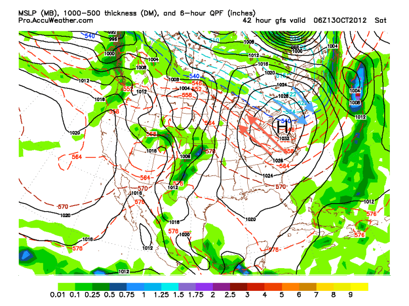
Most computer models are in consensus for this “first freeze.” The NAM and GFS forecast model both show the freezing line creeping all the way to South Jersey early Saturday morning. It shouldn’t stay below freezing for that long as temperatures will escalate near 60 on Saturday. This colder stretch is all in part to a strong high pressure sitting just to our west. Cold air from Quebec is being wrapped around the high and is coming down to the I-95 corridor.

Here is the GFS showing the high pressure just to our west at 2 AM Saturday. I drew arrows representing the cold and warm air to help people visualize the model:

GFS High Pressure Placement Analysis

Next week, a warm front followed by a weak cold front will pass through on Monday. After a cooler Tuesday, temperatures should slowly increase into the end of next week before a strong cold front arrives next weekend. The week of 22nd will likely have highs consistently in the 50s and lows near freezing.

Remember: First freeze is coming tomorrow night… put away any small plants for the night, to be safe.

Fall and Winter Patterns are Coming!


Yes! Philaburbia is back. Winter, snow, ice, and sleet are coming. It should be a wild and entertaining ride.

First on our agenda today are some stats from this summer. It was the 3rd warmest summer on record in the contiguous United States with an average temperature of 74.4 degrees. In the northeast, we had the 10th warmest June-August on record. Considering September was fairly average, I do not expect this rank to change significantly. Precipitation-wise from June-August the northeast received close to the average amount of rain expected. It was the 18 driest June-August overall in the country.

All this data can be found here… take a look, there are some very cool maps: http://www.ncdc.noaa.gov/sotc/national/2012/8

Tropics! In May, I predicted 10 named storms this year with 2 landfalls. In actuality, there were 14 named storms, 8 hurricanes, 1 major hurricane, and 3 US landfalls (Beryl, Debbie, and Isaac). My forecast was based on the weak el Niño forming from a fairly weak La Niña in the winter. Since there were only 7-8 years of this pattern in record, I did not have much data to work with. Even though Isaac created massive amounts of damage in the South, no major hurricane hit the Gulf or East coast this year. Hopefully this pattern will continue for as long as possible.

Here is the El Niño/La Niña map. Just as a refresher, positive anomalies mean El Niño; negative La Niña:

El Niño Map

Now for some current weather:

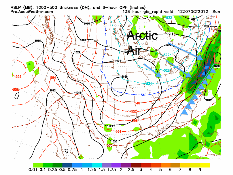
A weak low pressure will pass to our south and head out to sea. Some of this moisture from this front will reach our area tomorrow and Wednesday before high pressure sets up in the Southeast. Temperatures should increase by the end of the week (maybe some 80s), before a strong cold front crosses this Saturday Night/Sunday. After the front crosses, expect temperatures to tumble. It will likely be in the 60s next week and could drop into the 50s for highs the week after. It does not look like summer is returning for quite a while.

Here is the GFS model at 8 AM Sunday showing the cold front crossing the region. I made some cheap graphics to help people visualize (the dark blue line means the upper atmosphere is just below freezing (supports snow), but does not, however, necessarily mean surface temperatures are below freezing):

GFS Model 138

As Joe Bastardi says: “Enjoy the weather, cause it’s the only weather you got!”

Update on Isaac; Likely Into the Gulf


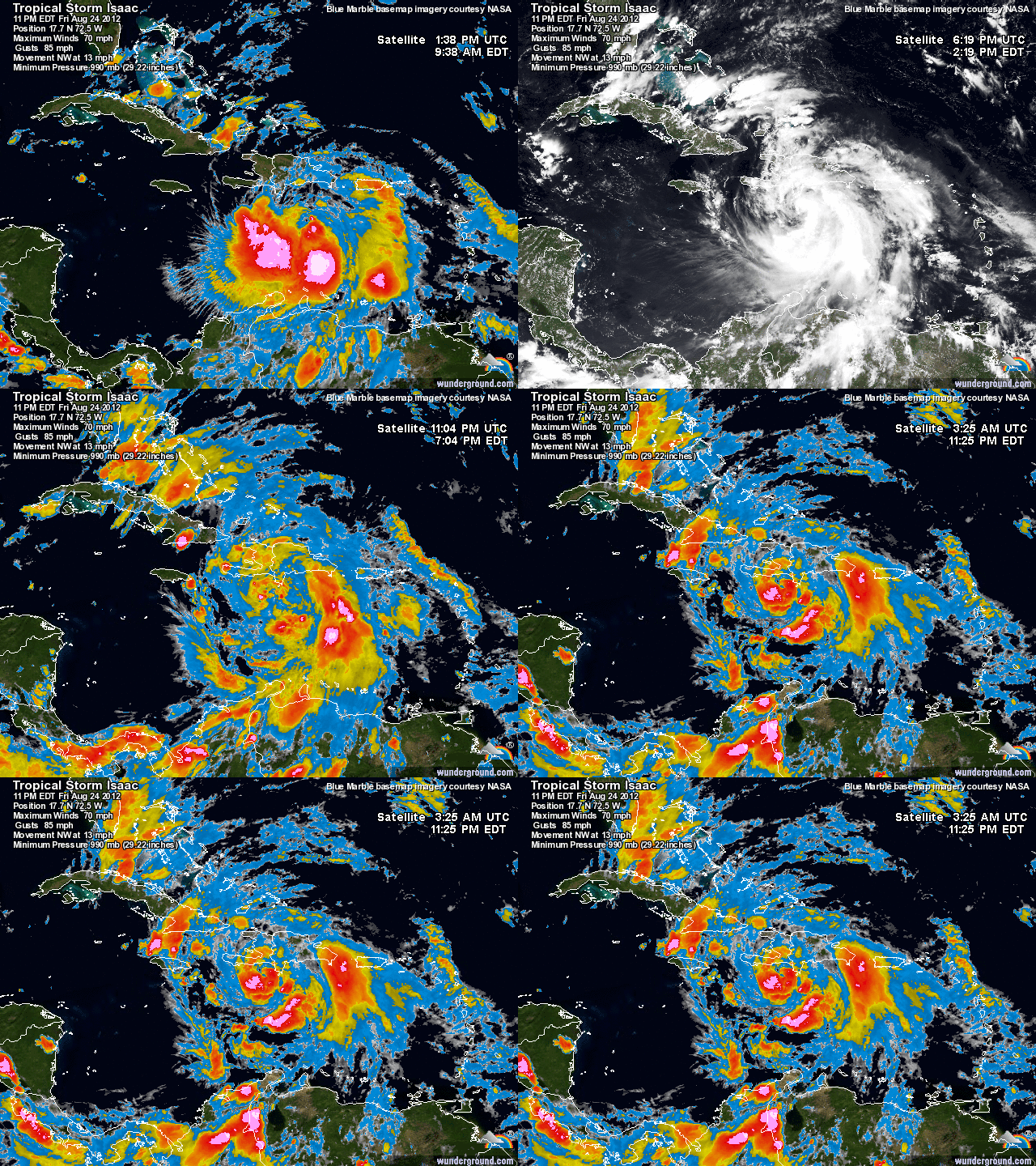
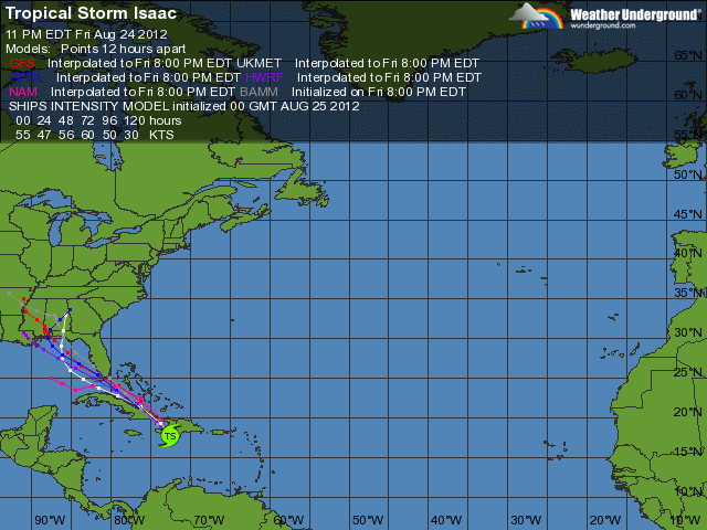
As I mentioned in my last post, Tropical Storm Isaac is bearing down on the US coastline. As of 11 PM EDT, Isaac is 65 miles south-southwest of Port Au Prince, Haiti, and is moving to the NW at 14 mph. Maximum sustained winds near the center of circulation are 70 mph, very close to category 1 hurricane strength. Minimum central pressure is 990 mb.

Current Isaac Satellite

The forecast models have been shifting east and west every run. Before Isaac crossed the Lesser Antilles, it seemed like an East Coast threat was possible. However, Isaac took more of a westerly path and is staying more south. Most models are in agreement about Isaac’s future path. They project Isaac strengthening into a Cat 2 storm and hitting somewhere between New Orleans and Tallahassee. The GFS model shows Isaac hitting Mobile, Alabama before getting absorbed by a frontal boundary moving east. The European model shows a similar solution but instead brings some of the remnants toward our area. The Canadian model is the outlier; it shows Isaac going east of Florida and into Georgia.

Model projections for Isaac

My forecast:

Over the past few hours, Isaac has taken a jog to the north. This can prove very crucial in future forecasts of Isaac’s track and strength. Because of this northward movement, I will still consider a track east of Florida possible. My official forecast however, brings Isaac north of Cuba into the Gulf of Mexico and hitting near Tallahassee, Florida. If our area is affected by Isaac late next week, there will likely be some drenching rain and some light winds. Other than that, it is looking to be a very interesting week for anyone living in Florida, Alabama, Mississippi, Louisiana, and Georgia.

IF the status of Isaac changes, I will post an update on the blog.


Tropical Depression 9/Isaac Will Threaten the East Coast Next Week


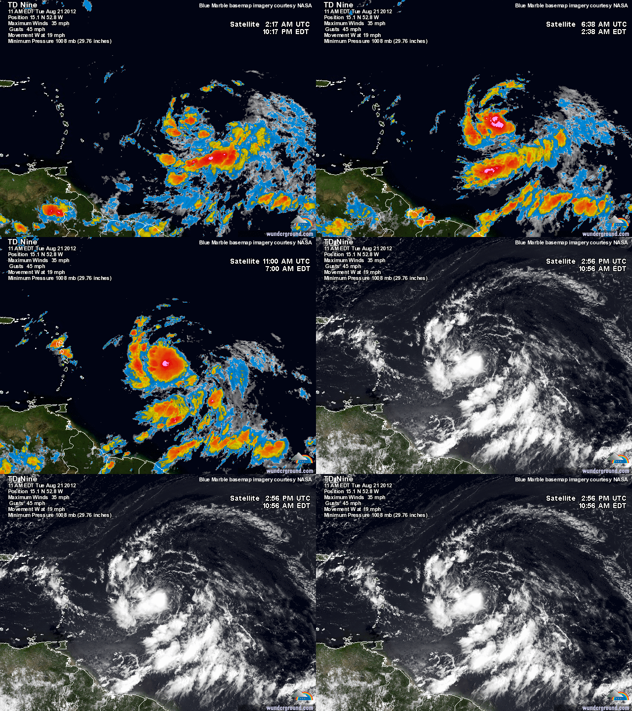
Hi everyone. As expected, the tropics are finally starting to become more active as we head into late August. I have been tracking a tropical wave located east of the Lesser Antilles for the past week or so. Just this morning, the National Hurricane Center upgraded the wave to a tropical depression (9). I imagine by tomorrow night, Tropical Storm Isaac will be born and will strengthen into a hurricane later this week.

The major debate associated with this storm is whether it will continue its westerly track and stay south of Hispaniola, Puerto Rico, and Cuba, or take a northward turn, becoming an Irene 2.0. Anybody living from Florida to New England should be watching this storm very closely. Isaac has many similarities to Irene position-wise and strength-wise. The high pressure setup is also favorable for a EC landfall as well.

Current Sat of TD9

The Forecast Model Disco:

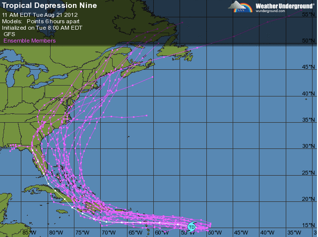
Many of the forecast models are showing Isaac moving south of Puerto Rico and Hispaniola, then taking a north turn toward Florida. Where Isaac makes the turn is becoming quite a debate between forecasters. Many of the models are disagreeing exactly where Isaac turns northward. The NAM is showing the turn over Hispaniola, while the GFS is showing the turn over Cuba.

The Importance of the Short-Range:

Even though it seems that most models are in agreement in the short-range, Irene proved to us that hurricanes seem to defy the forecast models especially during their strengthening phase.  Last August, Irene looked like she was going to stay south and head into Florida before turning NE out to sea. As Irene moved closer and closer to Puerto Rico and the Lesser Antilles however, a more northerly track looked likely; one that would affect the Eastern Seaboard.

Ensemble Models for Isaac


That’s the scare with TD9/Isaac. I am not confident in the track Isaac will take until he reaches the Lesser Antilles and Puerto Rico. Until then, I urge people to continue to stay with Philaburbia as I will be doing some video updates with model analysis over the next few days.


Moderate Risk of Severe Storms Today


For the second time this year, we are under a moderate risk for severe weather. A warm front moved through the area earlier this morning, which will push temperatures into the upper 90s later today. A frontal boundary is set up to our west and will push eastward into tonight. Large clusters of supercells will accompany bowing lines of storms later this evening along the front. CAPE values will also increase throughout the day, causing the atmosphere to become increasingly unstable. The heat, combined with an unstable atmosphere, is a classic recipe for a severe weather outbreak.

Wind Probabilities

The biggest threat with these storms will be wind damage. But an isolated tornado or hail report would not surprise me. As daytime heating occurs, storms should start to pop up in Western PA; when these storms do start to flare, I’d expect a Severe Thunderstorm Watch to be issued.

Sim radar 7 PM tonight

Remember, if you can hear thunder, then go inside as soon as you can. These storms today will pack quite a punch where they hit. 

Squall Line Possible This Evening


Hi everyone. This is a special alert post, as we have a threat for a damaging squall line to form. A warm front will pass through the area this morning and combine with a southerly flow, creating instability in the atmosphere this afternoon. Storms should form in northern PA by mid afternoon and start moving southeast. I do expect a severe thunderstorm watch to be issued by this afternoon, as the squall line gets its act together. The storms will mainly have very damaging winds and dangerous cloud to ground lightning. Skies should start to clear after 9 PM tonight, after the line moves through.

High res model 6 PM
High res model at 7 PM today

The Phillies are also playing tonight, and the game will likely be affected by these storms. We have another chance of t-storms tomorrow, as a cold front will move through the region.

Widespread Severe Outbreak Tomorrow


Hi everyone. After Sunday’s storms, it has gotten extremely hot throughout the Philadelphia region. Today’s highs reached into the upper 90s with heat indices in the 100s. All of this oppressive heat will end after a cold front passes through the region tomorrow.

Sim Radar 5PM Wed

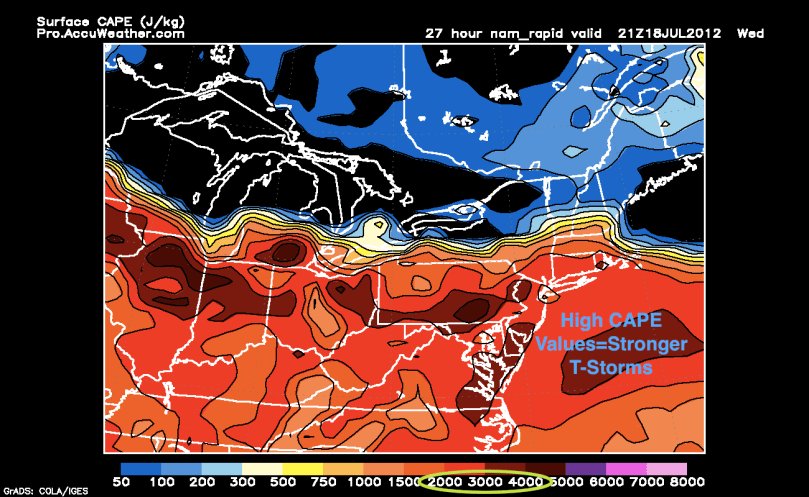
All of the heat ahead of the front,  instability of the atmosphere, and high CAPE values will fuel some very nasty thunderstorms tomorrow afternoon. The first cells should start popping up to the northwest of us around noon and begin to barrel southeastward toward the area. I expect a Severe Thunderstorm Watch to be issued in the morning tomorrow. The storms will have damaging winds, large hail (strongest storms will have hail that approaches 2″), and frequent lightning. If you see dark clouds tomorrow, go inside as soon as you can.

CAPE values Wed afternoon

After the storms pass by tomorrow, temperatures will moderate. Highs could only reach the upper 70s on Friday, before a slight warm up for the weekend.

Extreme Heat Coming This Week


Hi everyone. Even though been a while since my last post, I will continue to update the blog as we head into the dog days of summer and beyond.

Our area is currently under an Excessive Heat Warning, which is in effect from Wednesday afternoon through Friday night. This heat wave will be fueled by a strong Bermuda high sitting off the Atlantic coast. Temperatures will be in the high 90s and could reach 100 or hotter in some urban areas. The heat indices for Wednesday to Friday will climb near 105 degrees A cold front will sweep through the area on Friday night. Temperatures should moderate into next week before another we heat up again by July 1st.

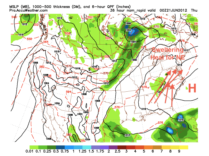
Sweltering Heat


The tropics have been quiet. There have been a few disturbances over the past few weeks that had a small chance to turn into tropical cyclones. None, however, have really turned into anything of note.

The El Niño is starting to take over and it is looking like it will continue to dominate into next Spring and Summer:

El Niño into next summer